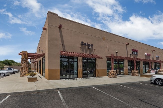
Property Record
4830 N Litchfield Rd, Litchfield Park, AZ 85340

NEARBY LISTINGS FOR SALE OR LEASE
Property Detail
4830 N Litchfield Rd
Phoenix-Mesa-Scottsdale, AZ
Plaza In The Park
501-68-921
PLAZA IN THE PARK MCR 705-22
Storebuilding
Maricopa
X
Arizona
04013C1690M
3
2025
1.31 AC
2025
N Goodyear/Litchfield
061010
Phoenix
9,692 SF
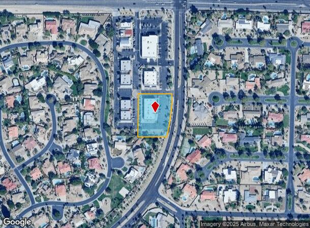
DEMOGRAPHICS near 4830 N Litchfield Rd
1 Mile
3 Mile
5 Mile
2024 Total Population
7,401
77,394
166,606
2029 Population
8,123
84,713
182,546
Pop Growth 2024-2029
+ 9.76%
+ 9.46%
+ 9.57%
Average Age
41
39
38
2024 Total Households
2,490
26,767
56,527
HH Growth 2024-2029
+ 9.84%
+ 9.60%
+ 9.74%
Median Household Inc
$118,343
$96,750
$84,742
Avg Household Size
2.90
2.80
2.90
2024 Avg HH Vehicles
2.00
2.00
2.00
Median Home Value
$553,264
$415,280
$374,108
Median Year Built
2004
2004
2003
Nearby Places
Map Layers
Map Styles
 Street
 Aerial
- Restaurants
- Banks
- Shops
- Fitness
- Groceries
PUBLIC TRANSPORTATION
AIRPORT
Phoenix Sky Harbor International
DRIVE
WALK
Distance
Phoenix Sky Harbor International
37 min
26.2 mi
SALE & LEASE HISTORY
LISTING DATE
SALE/LEASE

May 23, 2018
For Lease
Jun 15, 2021
For Lease
Jun 13, 2024
For Lease
Jun 07, 2017
For Lease
Aug 09, 2022
For Lease
Nearby Properties
Address
Land Use
TOTAL SIZE
Lot Size
Zoning
Address
Land Use
TOTAL SIZE
Lot Size
Zoning
71.40 AC
Address
Land Use
TOTAL SIZE
Lot Size
Zoning
76,301 SF
15.91 AC
Address
Land Use
TOTAL SIZE
Lot Size
Zoning
Address
Land Use
TOTAL SIZE
Lot Size
Zoning
1,188,764 SF
631.19 AC
AP
Address
Land Use
TOTAL SIZE
Lot Size
Zoning
1,433,378 SF
317.58 AC
AP
Address
Land Use
TOTAL SIZE
Lot Size
Zoning
2.51 AC
Address
Land Use
TOTAL SIZE
Lot Size
Zoning
510,342 SF
51.45 AC
LUKEAFB
Address
Land Use
TOTAL SIZE
Lot Size
Zoning
401,714 SF
100.01 AC
PAD
Address
Land Use
TOTAL SIZE
Lot Size
Zoning
802,439 SF
56.30 AC
PAD
Address
Land Use
TOTAL SIZE
Lot Size
Zoning
25.69 AC
Address
Land Use
TOTAL SIZE
Lot Size
Zoning
570,080 SF
36.76 AC
Address
Land Use
TOTAL SIZE
Lot Size
Zoning
844,524 SF
130.66 AC
LUKEAFB
Address
Land Use
TOTAL SIZE
Lot Size
Zoning
351,775 SF
53.72 AC
AP
Address
Land Use
TOTAL SIZE
Lot Size
Zoning
663,367 SF
38.83 AC
Address
Land Use
TOTAL SIZE
Lot Size
Zoning
599,070 SF
38.33 AC
Address
Land Use
TOTAL SIZE
Lot Size
Zoning
563,781 SF
34.84 AC
PAD
Address
Land Use
TOTAL SIZE
Lot Size
Zoning
295,014 SF
37.63 AC
PAD
Address
Land Use
TOTAL SIZE
Lot Size
Zoning
282,993 SF
14.16 AC
PF
Address
Land Use
TOTAL SIZE
Lot Size
Zoning
337,781 SF
9.11 AC
PF
Address
Land Use
TOTAL SIZE
Lot Size
Zoning
198,109 SF
79 AC
R-43
Address
Land Use
TOTAL SIZE
Lot Size
Zoning
295,635 SF
16.57 AC
PAD
Address
Land Use
TOTAL SIZE
Lot Size
Zoning
353,155 SF
16.80 AC
M-H
Address
Land Use
TOTAL SIZE
Lot Size
Zoning
340,061 SF
15.50 AC
M-H
Address
Land Use
TOTAL SIZE
Lot Size
Zoning
328,244 SF
18.44 AC
PAD
Address
Land Use
TOTAL SIZE
Lot Size
Zoning
106,351 SF
20 AC
PAD
Address
Land Use
TOTAL SIZE
Lot Size
Zoning
113,020 SF
16.37 AC
R-43
Address
Land Use
TOTAL SIZE
Lot Size
Zoning
189,996 SF
8.80 AC
PAD
Address
Land Use
TOTAL SIZE
Lot Size
Zoning
116,236 SF
12.68 AC
PAD
Address
Land Use
TOTAL SIZE
Lot Size
Zoning
109,856 SF
25.18 AC
R-43
Address
Land Use
TOTAL SIZE
Lot Size
Zoning
326,018 SF
21.03 AC
The World's #1 Commercial Real Estate Marketplace
Connect with us
© 2025 CoStar Group
The information above has been obtained from sources believed reliable. While we do not doubt its accuracy we have not verified it and make no guarantee, warranty or representation about it. It is your responsibility to independently confirm its accuracy and completeness. Any projections, opinions, assumptions, or estimates used are for example only and do not represent the current or future performance of the property. The value of this transaction to you depends on tax and other factors which should be evaluated by your tax, financial, and legal advisors. You and your advisors should conduct a careful, independent investigation of the property to determine to your satisfaction the suitability of the property for your needs.