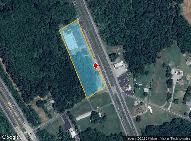
Property Record
4831 Dupont Pkwy, Townsend, DE 19734


NEARBY LISTINGS FOR SALE OR LEASE
-
-
View all Townsend listings for sale on LoopNet.com
Property Detail
4831 Dupont Pkwy
15-015.00-029
Dollar General Townsend
Storebuilding
New Castle
X
Delaware
10003C0407L
3.17 AC
2024
South New Castle County
2024
Philadelphia
016901
Philadelphia-Camden-Wilmington, PA-NJ-DE-MD
13,125 SF
DEMOGRAPHICS near 4831 Dupont Pkwy
1 Mile
3 Mile
5 Mile
2024 Total Population
865
4,601
27,317
2029 Population
883
4,694
28,452
Pop Growth 2024-2029
+ 2.08%
+ 2.02%
+ 4.15%
Average Age
45
44
40
2024 Total Households
249
1,238
8,902
HH Growth 2024-2029
+ 2.01%
+ 2.18%
+ 4.54%
Median Household Inc
$73,234
$88,888
$85,707
Avg Household Size
2.50
2.60
2.80
2024 Avg HH Vehicles
3.00
3.00
2.00
Median Home Value
$378,204
$383,092
$328,664
Median Year Built
1987
1988
1999
Nearby Places
Map Layers
Map Styles
 Street
 Aerial
- Restaurants
- Banks
- Shops
- Fitness
- Groceries
SALE & LEASE HISTORY
LISTING DATE
SALE/LEASE

Jan 12, 2017
For Sale
Nearby Properties
Address
Land Use
TOTAL SIZE
Lot Size
Zoning
Address
Land Use
TOTAL SIZE
Lot Size
Zoning
3,000 SF
543.36 AC
SR
Address
Land Use
TOTAL SIZE
Lot Size
Zoning
30,954 SF
23.93 AC
OR
Address
Land Use
TOTAL SIZE
Lot Size
Zoning
22,914 SF
14.26 AC
28I&R
Address
Land Use
TOTAL SIZE
Lot Size
Zoning
12,615 SF
60.63 AC
28I&R
Address
Land Use
TOTAL SIZE
Lot Size
Zoning
47,208 SF
5.05 AC
CR
Address
Land Use
TOTAL SIZE
Lot Size
Zoning
3,920 SF
7.12 AC
NC21
Address
Land Use
TOTAL SIZE
Lot Size
Zoning
8,928 SF
3.27 AC
NC2A
Address
Land Use
TOTAL SIZE
Lot Size
Zoning
9,600 SF
2.77 AC
CR
Address
Land Use
TOTAL SIZE
Lot Size
Zoning
10,450 SF
13.67 AC
28NCZ
Address
Land Use
TOTAL SIZE
Lot Size
Zoning
3,750 SF
2.23 AC
28H-C
Address
Land Use
TOTAL SIZE
Lot Size
Zoning
223.93 AC
SR
Address
Land Use
TOTAL SIZE
Lot Size
Zoning
195.99 AC
SR
Address
Land Use
TOTAL SIZE
Lot Size
Zoning
134.21 AC
SR
Address
Land Use
TOTAL SIZE
Lot Size
Zoning
9,105 SF
3.45 AC
28NCZ
Address
Land Use
TOTAL SIZE
Lot Size
Zoning
456 SF
98.25 AC
SR
Address
Land Use
TOTAL SIZE
Lot Size
Zoning
212.40 AC
SR
Address
Land Use
TOTAL SIZE
Lot Size
Zoning
5,084 SF
7.90 AC
CR
Address
Land Use
TOTAL SIZE
Lot Size
Zoning
175.34 AC
SR
Address
Land Use
TOTAL SIZE
Lot Size
Zoning
3,249 SF
2.82 AC
CR
Address
Land Use
TOTAL SIZE
Lot Size
Zoning
3,288 SF
61.57 AC
SR
Address
Land Use
TOTAL SIZE
Lot Size
Zoning
12,182 SF
3.13 AC
CR
Address
Land Use
TOTAL SIZE
Lot Size
Zoning
2,800 SF
5 AC
NC21
Address
Land Use
TOTAL SIZE
Lot Size
Zoning
139.41 AC
SR
Address
Land Use
TOTAL SIZE
Lot Size
Zoning
2,500 SF
0.37 AC
CR
Address
Land Use
TOTAL SIZE
Lot Size
Zoning
1,290 SF
1.48 AC
CR
Address
Land Use
TOTAL SIZE
Lot Size
Zoning
6,015 SF
8.07 AC
CR
Address
Land Use
TOTAL SIZE
Lot Size
Zoning
5,704 SF
1.38 AC
CR
Address
Land Use
TOTAL SIZE
Lot Size
Zoning
1,952 SF
3.72 AC
SR
Address
Land Use
TOTAL SIZE
Lot Size
Zoning
4,343 SF
1.83 AC
28H-C
The World's #1 Commercial Real Estate Marketplace
Connect with us
© 2026 CoStar Group
The information above has been obtained from sources believed reliable. While we do not doubt its accuracy we have not verified it and make no guarantee, warranty or representation about it. It is your responsibility to independently confirm its accuracy and completeness. Any projections, opinions, assumptions, or estimates used are for example only and do not represent the current or future performance of the property. The value of this transaction to you depends on tax and other factors which should be evaluated by your tax, financial, and legal advisors. You and your advisors should conduct a careful, independent investigation of the property to determine to your satisfaction the suitability of the property for your needs.