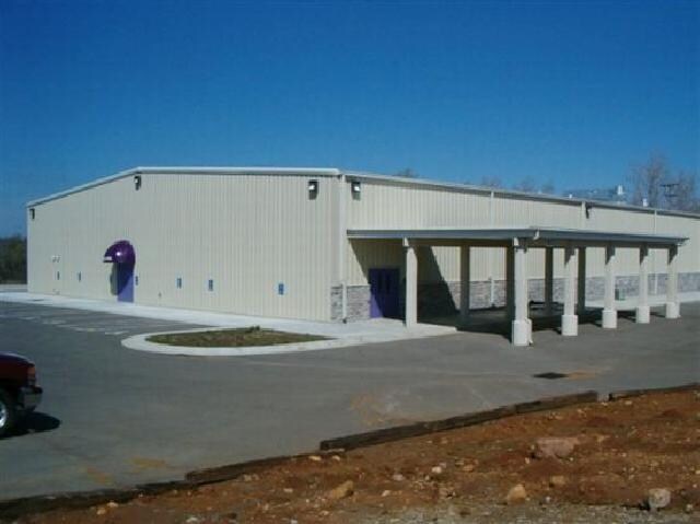
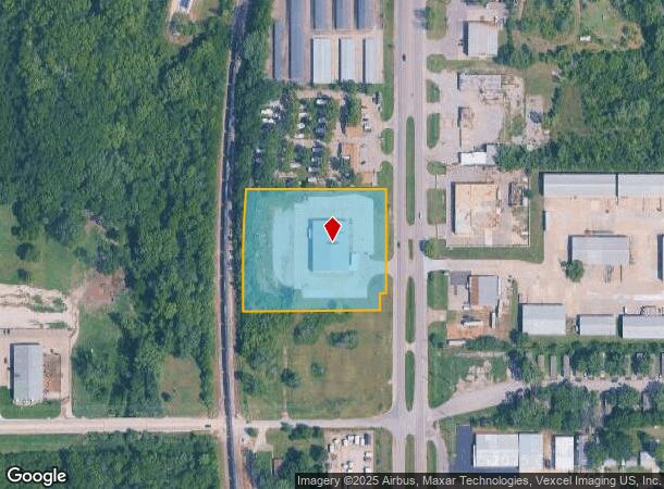
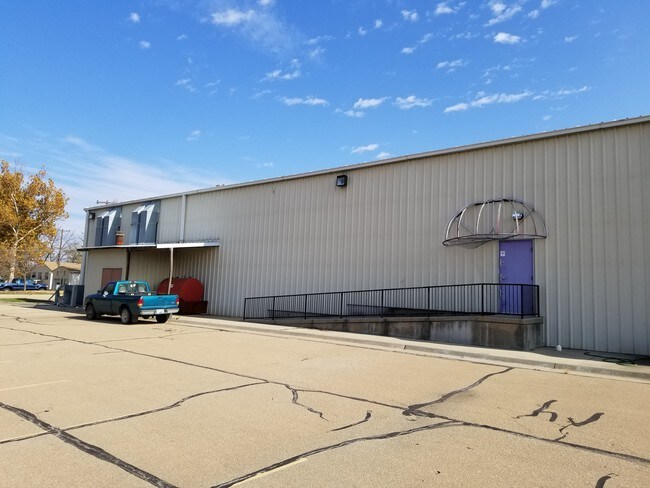
Property Record
4831 Sw Topeka Blvd, Topeka, KS 66609
NEARBY LISTINGS FOR SALE OR LEASE
-
-
-
-
-
-
7215 SW Topeka Blvd., Bldg. 2703, Topeka, KS 66619
Topeka, KS 66619
$2.60 SF/YR
38,800 SF
Industrial
-
-
View all Topeka listings for sale on LoopNet.com
Property Detail
4831 Sw Topeka Blvd
Topeka, KS
Bullseye Business Pk
147-25-0-10-01-008-010
BULLSEYE BUSINESS PK , LOT 1 + , LOTS 1-2 BULLSEYE BUSINESS PARK SECTION 25 TOWNSHIP 12 RANGE 15
Shipyard
Shawnee
X
Kansas
20177C0302E
1
2024
3.10 AC
2025
Topeka
003701
Kansas City
14,000 SF
DEMOGRAPHICS near 4831 Sw Topeka Blvd
1 Mile
3 Mile
5 Mile
2024 Total Population
1,807
32,111
95,041
2029 Population
1,794
31,836
94,401
Pop Growth 2024-2029
(0.72%)
(0.86%)
(0.67%)
Average Age
42
39
39
2024 Total Households
778
13,159
39,572
HH Growth 2024-2029
(0.51%)
(0.90%)
(0.71%)
Median Household Inc
$54,896
$50,772
$51,511
Avg Household Size
2.30
2.30
2.30
2024 Avg HH Vehicles
2.00
2.00
2.00
Median Home Value
$101,681
$129,550
$130,593
Median Year Built
1993
1972
1969
Nearby Places
Map Layers
Map Styles
 Street
 Aerial
- Restaurants
- Banks
- Shops
- Fitness
- Groceries
PUBLIC TRANSPORTATION
COMMUTER RAIL
DRIVE
WALK
Distance
11 min
6.0 mi
SALE & LEASE HISTORY
LISTING DATE
SALE/LEASE

Nov 08, 2017
For Sale
Nearby Properties
Address
Land Use
TOTAL SIZE
Lot Size
Zoning
Address
Land Use
TOTAL SIZE
Lot Size
Zoning
77,776 SF
10.64 AC
PUD,M2,R1,
Address
Land Use
TOTAL SIZE
Lot Size
Zoning
19,120 SF
2.08 AC
R1
Address
Land Use
TOTAL SIZE
Lot Size
Zoning
797,582 SF
384.32 AC
I1,I2
Address
Land Use
TOTAL SIZE
Lot Size
Zoning
152,049 SF
25.61 AC
R1
Address
Land Use
TOTAL SIZE
Lot Size
Zoning
103,285 SF
16.99 AC
I1,PUD
Address
Land Use
TOTAL SIZE
Lot Size
Zoning
1,351,980 SF
141.63 AC
I1
Address
Land Use
TOTAL SIZE
Lot Size
Zoning
602,448 SF
43.68 AC
I1
Address
Land Use
TOTAL SIZE
Lot Size
Zoning
165,001 SF
24.83 AC
R1
Address
Land Use
TOTAL SIZE
Lot Size
Zoning
52,261 SF
4.59 AC
OI3
Address
Land Use
TOTAL SIZE
Lot Size
Zoning
100,954 SF
77.35 AC
R1
Address
Land Use
TOTAL SIZE
Lot Size
Zoning
1,250 SF
630.34 AC
RR1
Address
Land Use
TOTAL SIZE
Lot Size
Zoning
156,628 SF
44.05 AC
I1
Address
Land Use
TOTAL SIZE
Lot Size
Zoning
465,600 SF
52.91 AC
I1
Address
Land Use
TOTAL SIZE
Lot Size
Zoning
40,321 SF
5.69 AC
I1
Address
Land Use
TOTAL SIZE
Lot Size
Zoning
53,815 SF
15.40 AC
RR1
Address
Land Use
TOTAL SIZE
Lot Size
Zoning
38,858 SF
1.01 AC
R1
Address
Land Use
TOTAL SIZE
Lot Size
Zoning
188,358 SF
183.64 AC
I1,RR1
Address
Land Use
TOTAL SIZE
Lot Size
Zoning
56,485 SF
11.58 AC
I1
Address
Land Use
TOTAL SIZE
Lot Size
Zoning
15,893 SF
0.64 AC
R1
Address
Land Use
TOTAL SIZE
Lot Size
Zoning
4.81 AC
Address
Land Use
TOTAL SIZE
Lot Size
Zoning
37,132 SF
13.48 AC
R1
Address
Land Use
TOTAL SIZE
Lot Size
Zoning
38,866 SF
9.40 AC
R1
Address
Land Use
TOTAL SIZE
Lot Size
Zoning
3,525 SF
1.89 AC
C3
Address
Land Use
TOTAL SIZE
Lot Size
Zoning
64,248 SF
13.78 AC
RR1
Address
Land Use
TOTAL SIZE
Lot Size
Zoning
14,650 SF
3.64 AC
M2,R1
Address
Land Use
TOTAL SIZE
Lot Size
Zoning
40,591 SF
6.19 AC
R1
Address
Land Use
TOTAL SIZE
Lot Size
Zoning
89,377 SF
11.06 AC
I2
Address
Land Use
TOTAL SIZE
Lot Size
Zoning
35,832 SF
7.55 AC
R1
Address
Land Use
TOTAL SIZE
Lot Size
Zoning
207,235 SF
22.74 AC
C3
Address
Land Use
TOTAL SIZE
Lot Size
Zoning
23,026 SF
8.62 AC
R1,RR1
The World's #1 Commercial Real Estate Marketplace
Connect with us
© 2025 CoStar Group
The information above has been obtained from sources believed reliable. While we do not doubt its accuracy we have not verified it and make no guarantee, warranty or representation about it. It is your responsibility to independently confirm its accuracy and completeness. Any projections, opinions, assumptions, or estimates used are for example only and do not represent the current or future performance of the property. The value of this transaction to you depends on tax and other factors which should be evaluated by your tax, financial, and legal advisors. You and your advisors should conduct a careful, independent investigation of the property to determine to your satisfaction the suitability of the property for your needs.