Property Record
4833 Pecos St, Denver, CO 80221
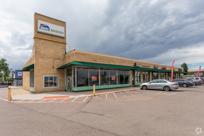


This Property Is For Sale
Property Detail
4833 Pecos St
2163-28-012
PORTION BLK5
Storebuilding
DENVER
E-CC-3X
Colorado
B and X Area of moderate flood hazard, usually the area between the limits of the 100-year and 500-year floods.
1.52 AC
2024
Northwest
2025
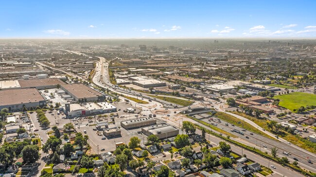
Denver
000201
Denver-Aurora-Centennial, CO
32,639 SF
NEARBY LISTINGS FOR SALE OR LEASE
DEMOGRAPHICS near 4833 Pecos St
1 mile
3 mile
5 mile
2025 Total Population
14,911
158,856
440,613
2030 Population
15,527
164,751
452,734
Pop Growth 2025-2030
+ 4.13%
+ 3.71%
+ 2.75%
Average Age
38
37
38
2025 Total Households
5,855
75,618
204,109
HH Growth 2025-2030
+ 3.95%
+ 3.77%
+ 2.86%
Median Household Inc
$99,124
$109,879
$93,533
Avg Household Size
2.40
2.00
2.10
2025 Avg HH Vehicles
2.00
2.00
2.00
Median Home Value
$709,730
$728,263
$637,781
Median Year Built
1954
1990
1970
Nearby Places
Map Layers
Map Styles
 Street
 Aerial
Layers
 Traffic
 Biking
Places
Listings with unknown addresses are not visible on the map
- Restaurants
- Banks
- Shops
- Fitness
- Groceries
PUBLIC TRANSPORTATION
COMMUTER RAIL
41St & Fox Station Track 1 (Union Station to Westminster Station - Regional Transportation District, Union Station to Wheat Ridge Ward Station - Regional Transportation District)
Drive
Walk
Distance
41St & Fox Station Track 1 (Union Station to Westminster Station - Regional Transportation District, Union Station to Wheat Ridge Ward Station - Regional Transportation District)
5 min
2.4 mi
41St & Fox Station Track 2 (Union Station to Westminster Station - Regional Transportation District, Union Station to Wheat Ridge Ward Station - Regional Transportation District)
Drive
Walk
Distance
41St & Fox Station Track 2 (Union Station to Westminster Station - Regional Transportation District, Union Station to Wheat Ridge Ward Station - Regional Transportation District)
5 min
2.4 mi
AIRPORT
Denver International
Drive
Walk
Distance
Denver International
29 min
23.3 mi
Freight Ports
Tulsa Port Of Catoosa
Drive
Walk
Distance
Tulsa Port Of Catoosa
726 min
708.8 mi
Nearby Properties
Address
Land Use
TOTAL SIZE
Lot Size
Zoning
Address
Land Use
TOTAL SIZE
Lot Size
Zoning
921,863 SF
2.01 AC
C-MX
Address
Land Use
TOTAL SIZE
Lot Size
Zoning
1,882,179 SF
21.15 AC
D-TD
Address
Land Use
TOTAL SIZE
Lot Size
Zoning
552,279 SF
2.22 AC
C-RX
Address
Land Use
TOTAL SIZE
Lot Size
Zoning
1,721,086 SF
21.34 AC
C-MU-30
Address
Land Use
TOTAL SIZE
Lot Size
Zoning
798,837 SF
1.67 AC
C-MX
Address
Land Use
TOTAL SIZE
Lot Size
Zoning
565,418 SF
4.07 AC
C-RX
Address
Land Use
TOTAL SIZE
Lot Size
Zoning
657,947 SF
5.02 AC
C-RX
Address
Land Use
TOTAL SIZE
Lot Size
Zoning
729,679 SF
C-MX
Address
Land Use
TOTAL SIZE
Lot Size
Zoning
6,252 SF
1.05 AC
C-MX
Address
Land Use
TOTAL SIZE
Lot Size
Zoning
794,383 SF
0.90 AC
D-TD
Address
Land Use
TOTAL SIZE
Lot Size
Zoning
694,425 SF
1.92 AC
C-MX
Address
Land Use
TOTAL SIZE
Lot Size
Zoning
411,402 SF
6.34 AC
C-RX
Address
Land Use
TOTAL SIZE
Lot Size
Zoning
405,436 SF
2.45 AC
C-MX
Address
Land Use
TOTAL SIZE
Lot Size
Zoning
299,368 SF
0.71 AC
C-MX
Address
Land Use
TOTAL SIZE
Lot Size
Zoning
311,406 SF
1.74 AC
C-MX
Address
Land Use
TOTAL SIZE
Lot Size
Zoning
294,950 SF
6.91 AC
C-RX-12
Address
Land Use
TOTAL SIZE
Lot Size
Zoning
310,267 SF
1.69 AC
C-MX
Address
Land Use
TOTAL SIZE
Lot Size
Zoning
402,700 SF
1.15 AC
C-RX
Address
Land Use
TOTAL SIZE
Lot Size
Zoning
411,031 SF
1.66 AC
I-MX
Address
Land Use
TOTAL SIZE
Lot Size
Zoning
352,226 SF
1.01 AC
ASQ
Address
Land Use
TOTAL SIZE
Lot Size
Zoning
1,048,471 SF
2.44 AC
PUD
Address
Land Use
TOTAL SIZE
Lot Size
Zoning
412,345 SF
0.82 AC
C-MX
Address
Land Use
TOTAL SIZE
Lot Size
Zoning
365,674 SF
2.60 AC
G-MU
Address
Land Use
TOTAL SIZE
Lot Size
Zoning
417,566 SF
2.60 AC
G-MU
Address
Land Use
TOTAL SIZE
Lot Size
Zoning
1,567,575 SF
1.40 AC
D-C
Address
Land Use
TOTAL SIZE
Lot Size
Zoning
318,052 SF
2.73 AC
C-MX
Address
Land Use
TOTAL SIZE
Lot Size
Zoning
1,542,612 SF
1.56 AC
D-C
Address
Land Use
TOTAL SIZE
Lot Size
Zoning
614,750 SF
0.23 AC
D-C
Address
Land Use
TOTAL SIZE
Lot Size
Zoning
424,200 SF
1.15 AC
C-RX
Address
Land Use
TOTAL SIZE
Lot Size
Zoning
611,828 SF
0.94 AC
PUD
The World's #1 Commercial Real Estate Marketplace
Connect with us
© 2026 CoStar Group
The information above has been obtained from sources believed reliable. While we do not doubt its accuracy we have not verified it and make no guarantee, warranty or representation about it. It is your responsibility to independently confirm its accuracy and completeness. Any projections, opinions, assumptions, or estimates used are for example only and do not represent the current or future performance of the property. The value of this transaction to you depends on tax and other factors which should be evaluated by your tax, financial, and legal advisors. You and your advisors should conduct a careful, independent investigation of the property to determine to your satisfaction the suitability of the property for your needs.