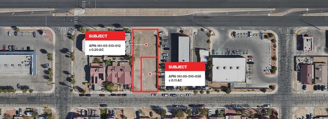
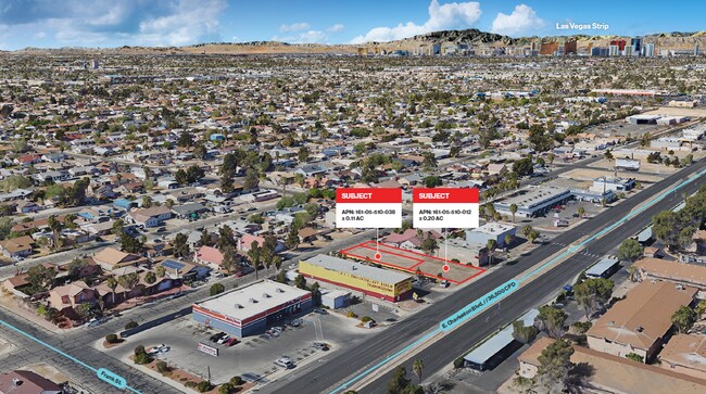
Property Record
1475 Ringe Ln, Las Vegas, NV 89110
NEARBY LISTINGS FOR SALE OR LEASE
Property Detail
1475 Ringe Ln
Las Vegas-Henderson-Paradise, NV
Vegas Manor Tract 1
161-05-510-012
VEGAS MANOR TRACT 1 PLAT BOOK 1 PAGE 60 LOT 8 BLOCK 21 & LOTS 9,10,41
Vacantlandnec
Clark
X
Nevada
32003C2187F
8
2025
0.20 AC
2025
Central East Las Vegas
001611
Las Vegas
DEMOGRAPHICS near 1475 Ringe Ln
1 Mile
3 Mile
5 Mile
2024 Total Population
30,842
233,322
483,500
2029 Population
32,303
246,485
512,941
Pop Growth 2024-2029
+ 4.74%
+ 5.64%
+ 6.09%
Average Age
36
37
37
2024 Total Households
9,598
77,784
167,780
HH Growth 2024-2029
+ 4.74%
+ 5.60%
+ 6.14%
Median Household Inc
$44,430
$41,869
$42,119
Avg Household Size
3.20
2.90
2.80
2024 Avg HH Vehicles
2.00
2.00
2.00
Median Home Value
$245,300
$245,234
$255,023
Median Year Built
1984
1986
1984
Nearby Places
Map Layers
Map Styles
 Street
 Aerial
- Restaurants
- Banks
- Shops
- Fitness
- Groceries
PUBLIC TRANSPORTATION
AIRPORT
Harry Reid International
DRIVE
WALK
Distance
Harry Reid International
21 min
12.9 mi
Boulder City Municipal
DRIVE
WALK
Distance
Boulder City Municipal
36 min
24.2 mi
Freight Ports
Port of Long Beach
DRIVE
WALK
Distance
Port of Long Beach
327 min
291.2 mi
SALE & LEASE HISTORY
LISTING DATE
SALE/LEASE

Nov 12, 2024
For Sale
Nearby Properties
Address
Land Use
TOTAL SIZE
Lot Size
Zoning
Address
Land Use
TOTAL SIZE
Lot Size
Zoning
90.41 AC
Address
Land Use
TOTAL SIZE
Lot Size
Zoning
747,196 SF
40.03 AC
Address
Land Use
TOTAL SIZE
Lot Size
Zoning
67,649 SF
13.42 AC
CV
Address
Land Use
TOTAL SIZE
Lot Size
Zoning
29.35 AC
CV
Address
Land Use
TOTAL SIZE
Lot Size
Zoning
342,160 SF
37.72 AC
RT
Address
Land Use
TOTAL SIZE
Lot Size
Zoning
201,218 SF
36.38 AC
Address
Land Use
TOTAL SIZE
Lot Size
Zoning
20.91 AC
PF
Address
Land Use
TOTAL SIZE
Lot Size
Zoning
1,008 SF
31.47 AC
PF
Address
Land Use
TOTAL SIZE
Lot Size
Zoning
58,188 SF
20.04 AC
L:C-V
Address
Land Use
TOTAL SIZE
Lot Size
Zoning
339,280 SF
18.19 AC
Address
Land Use
TOTAL SIZE
Lot Size
Zoning
4.34 AC
RE
Address
Land Use
TOTAL SIZE
Lot Size
Zoning
374,712 SF
18.88 AC
MD
Address
Land Use
TOTAL SIZE
Lot Size
Zoning
19.30 AC
RE
Address
Land Use
TOTAL SIZE
Lot Size
Zoning
420,000 SF
21.23 AC
M1
Address
Land Use
TOTAL SIZE
Lot Size
Zoning
282,204 SF
18 AC
MD
Address
Land Use
TOTAL SIZE
Lot Size
Zoning
421,000 SF
19.59 AC
M1
Address
Land Use
TOTAL SIZE
Lot Size
Zoning
223,422 SF
18.21 AC
R3
Address
Land Use
TOTAL SIZE
Lot Size
Zoning
9,044 SF
8.62 AC
Address
Land Use
TOTAL SIZE
Lot Size
Zoning
2,926 SF
19.73 AC
R3
Address
Land Use
TOTAL SIZE
Lot Size
Zoning
3,183 SF
18.35 AC
R3
Address
Land Use
TOTAL SIZE
Lot Size
Zoning
307,997 SF
14.01 AC
Address
Land Use
TOTAL SIZE
Lot Size
Zoning
9.11 AC
PF
Address
Land Use
TOTAL SIZE
Lot Size
Zoning
11.69 AC
CV
Address
Land Use
TOTAL SIZE
Lot Size
Zoning
300,773 SF
17.24 AC
Address
Land Use
TOTAL SIZE
Lot Size
Zoning
346,598 SF
17.95 AC
M1
Address
Land Use
TOTAL SIZE
Lot Size
Zoning
321,292 SF
16.67 AC
R3
Address
Land Use
TOTAL SIZE
Lot Size
Zoning
8.87 AC
PF
Address
Land Use
TOTAL SIZE
Lot Size
Zoning
231,434 SF
20.31 AC
M
Address
Land Use
TOTAL SIZE
Lot Size
Zoning
8.39 AC
CV
Address
Land Use
TOTAL SIZE
Lot Size
Zoning
11.81 AC
RE
The World's #1 Commercial Real Estate Marketplace
Connect with us
© 2025 CoStar Group
The information above has been obtained from sources believed reliable. While we do not doubt its accuracy we have not verified it and make no guarantee, warranty or representation about it. It is your responsibility to independently confirm its accuracy and completeness. Any projections, opinions, assumptions, or estimates used are for example only and do not represent the current or future performance of the property. The value of this transaction to you depends on tax and other factors which should be evaluated by your tax, financial, and legal advisors. You and your advisors should conduct a careful, independent investigation of the property to determine to your satisfaction the suitability of the property for your needs.