Property Record
4835 Kietzke Ln, Reno, NV 89509


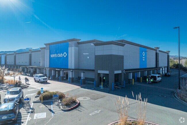
Property Detail
4835 Kietzke Ln
024-055-52
PM 4095 LOT 1
Commercialnec
Washoe
MU
Nevada
B and X Area of moderate flood hazard, usually the area between the limits of the 100-year and 500-year floods.
1
2025
12.17 AC
2026
Meadowood
001005
Reno/Sparks
150,626 SF
Reno, NV
NEARBY LISTINGS FOR SALE OR LEASE
DEMOGRAPHICS near 4835 Kietzke Ln
1 mile
3 mile
5 mile
2025 Total Population
15,214
85,538
201,895
2030 Population
15,556
87,306
206,926
Pop Growth 2025-2030
+ 2.25%
+ 2.07%
+ 2.49%
Average Age
39
41
40
2025 Total Households
6,423
37,523
86,382
HH Growth 2025-2030
+ 2.27%
+ 2.17%
+ 2.57%
Median Household Inc
$65,509
$70,714
$70,178
Avg Household Size
2.30
2.20
2.20
2025 Avg HH Vehicles
2.00
2.00
2.00
Median Home Value
$539,349
$588,017
$595,566
Median Year Built
1978
1977
1982
Nearby Places
Map Layers
Map Styles
 Street
 Aerial
Layers
 Traffic
 Biking
Places
Listings with unknown addresses are not visible on the map
- Restaurants
- Banks
- Shops
- Fitness
- Groceries
PUBLIC TRANSPORTATION
COMMUTER RAIL
Drive
Walk
Distance
10 min
3.9 mi
AIRPORT
Reno/Tahoe International
Drive
Walk
Distance
Reno/Tahoe International
11 min
4.9 mi
Nearby Properties
Address
Land Use
TOTAL SIZE
Lot Size
Zoning
Address
Land Use
TOTAL SIZE
Lot Size
Zoning
1,638,272 SF
17.11 AC
MU
Address
Land Use
TOTAL SIZE
Lot Size
Zoning
762,384 SF
1,131.28 AC
MA
Address
Land Use
TOTAL SIZE
Lot Size
Zoning
799,762 SF
13.30 AC
MU
Address
Land Use
TOTAL SIZE
Lot Size
Zoning
390,743 SF
22.20 AC
IC
Address
Land Use
TOTAL SIZE
Lot Size
Zoning
1,051,043 SF
78.81 AC
PD
Address
Land Use
TOTAL SIZE
Lot Size
Zoning
425,118 SF
30.37 AC
IC
Address
Land Use
TOTAL SIZE
Lot Size
Zoning
759,161 SF
37.37 AC
MU
Address
Land Use
TOTAL SIZE
Lot Size
Zoning
893,055 SF
52.71 AC
MA
Address
Land Use
TOTAL SIZE
Lot Size
Zoning
451,635 SF
15 AC
PD
Address
Land Use
TOTAL SIZE
Lot Size
Zoning
497,928 SF
3.52 AC
MU
Address
Land Use
TOTAL SIZE
Lot Size
Zoning
645,699 SF
4.53 AC
MU
Address
Land Use
TOTAL SIZE
Lot Size
Zoning
421,744 SF
12.07 AC
MS
Address
Land Use
TOTAL SIZE
Lot Size
Zoning
500,079 SF
45.66 AC
SPD
Address
Land Use
TOTAL SIZE
Lot Size
Zoning
342,019 SF
23.32 AC
MF14
Address
Land Use
TOTAL SIZE
Lot Size
Zoning
109,936 SF
1.80 AC
MD-RD
Address
Land Use
TOTAL SIZE
Lot Size
Zoning
366,641 SF
37.91 AC
MA
Address
Land Use
TOTAL SIZE
Lot Size
Zoning
231,329 SF
8.37 AC
GC
Address
Land Use
TOTAL SIZE
Lot Size
Zoning
591,000 SF
5.46 AC
MU
Address
Land Use
TOTAL SIZE
Lot Size
Zoning
322,180 SF
2.87 AC
MU
Address
Land Use
TOTAL SIZE
Lot Size
Zoning
149,324 SF
4.34 AC
PD
Address
Land Use
TOTAL SIZE
Lot Size
Zoning
159,803 SF
0.60 AC
MD-RD
Address
Land Use
TOTAL SIZE
Lot Size
Zoning
253,751 SF
1.02 AC
MD-RD
Address
Land Use
TOTAL SIZE
Lot Size
Zoning
270,950 SF
14.86 AC
IC
Address
Land Use
TOTAL SIZE
Lot Size
Zoning
170,507 SF
17.24 AC
GC
Address
Land Use
TOTAL SIZE
Lot Size
Zoning
80,970 SF
5.28 AC
MS
Address
Land Use
TOTAL SIZE
Lot Size
Zoning
181,296 SF
2.65 AC
MU
Address
Land Use
TOTAL SIZE
Lot Size
Zoning
117,360 SF
1.75 AC
MU
Address
Land Use
TOTAL SIZE
Lot Size
Zoning
146,586 SF
2.94 AC
IC
Address
Land Use
TOTAL SIZE
Lot Size
Zoning
248,542 SF
0.49 AC
MD-ED
Address
Land Use
TOTAL SIZE
Lot Size
Zoning
381,852 SF
18.60 AC
GC
The World's #1 Commercial Real Estate Marketplace
Connect with us
© 2026 CoStar Group
The information above has been obtained from sources believed reliable. While we do not doubt its accuracy we have not verified it and make no guarantee, warranty or representation about it. It is your responsibility to independently confirm its accuracy and completeness. Any projections, opinions, assumptions, or estimates used are for example only and do not represent the current or future performance of the property. The value of this transaction to you depends on tax and other factors which should be evaluated by your tax, financial, and legal advisors. You and your advisors should conduct a careful, independent investigation of the property to determine to your satisfaction the suitability of the property for your needs.