Property Record
4835 Waterlick Rd, Forest, VA 24551
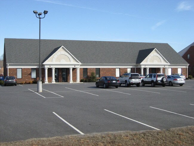


Property Detail
4835 Waterlick Rd
Lynchburg, VA
WESTWOOD PROFESSIONAL CENTER LT 2 PB 42/145
136B-8-2
Bedford
Commercialnec
Virginia
B and X Area of moderate flood hazard, usually the area between the limits of the 100-year and 500-year floods.
2
2025
1.02 AC
2025
Lynchburg
030104
Other Market Areas
12,000 SF
NEARBY LISTINGS FOR SALE OR LEASE
DEMOGRAPHICS near 4835 Waterlick Rd
1 mile
3 mile
5 mile
2025 Total Population
4,687
32,220
59,583
2030 Population
4,678
32,295
60,339
Pop Growth 2025-2030
(0.19%)
+ 0.23%
+ 1.27%
Average Age
42
40
40
2025 Total Households
1,882
13,428
24,491
HH Growth 2025-2030
(0.27%)
+ 0.19%
+ 1.23%
Median Household Inc
$80,559
$70,551
$72,127
Avg Household Size
2.50
2.30
2.40
2025 Avg HH Vehicles
2.00
2.00
2.00
Median Home Value
$272,116
$271,451
$280,092
Median Year Built
1982
1988
1989
Nearby Places
Map Layers
Map Styles
 Street
 Aerial
Layers
 Traffic
 Biking
Places
Listings with unknown addresses are not visible on the map
- Restaurants
- Banks
- Shops
- Fitness
- Groceries
PUBLIC TRANSPORTATION
AIRPORT
Lynchburg Regional/Preston Glenn Field
Drive
Walk
Distance
Lynchburg Regional/Preston Glenn Field
13 min
5.3 mi
SALE & LEASE HISTORY
LISTING DATE
SALE/LEASE

Aug 20, 2021
For Lease
Nearby Properties
Address
Land Use
TOTAL SIZE
Lot Size
Zoning
Address
Land Use
TOTAL SIZE
Lot Size
Zoning
22.70 AC
Address
Land Use
TOTAL SIZE
Lot Size
Zoning
912 SF
52.88 AC
BGC
Address
Land Use
TOTAL SIZE
Lot Size
Zoning
199,056 SF
16.21 AC
R1
Address
Land Use
TOTAL SIZE
Lot Size
Zoning
36,168 SF
7.96 AC
BGC
Address
Land Use
TOTAL SIZE
Lot Size
Zoning
155,125 SF
38.67 AC
250129
Address
Land Use
TOTAL SIZE
Lot Size
Zoning
9,508 SF
8.54 AC
RMF
Address
Land Use
TOTAL SIZE
Lot Size
Zoning
1,120 SF
16.81 AC
RMF
Address
Land Use
TOTAL SIZE
Lot Size
Zoning
Address
Land Use
TOTAL SIZE
Lot Size
Zoning
Address
Land Use
TOTAL SIZE
Lot Size
Zoning
3,478 SF
13.10 AC
RMFC
Address
Land Use
TOTAL SIZE
Lot Size
Zoning
537,608 SF
47.65 AC
152919
Address
Land Use
TOTAL SIZE
Lot Size
Zoning
161,333 SF
10.60 AC
2119
Address
Land Use
TOTAL SIZE
Lot Size
Zoning
Address
Land Use
TOTAL SIZE
Lot Size
Zoning
76,421 SF
25.07 AC
R2RC
Address
Land Use
TOTAL SIZE
Lot Size
Zoning
95,792 SF
3.28 AC
Address
Land Use
TOTAL SIZE
Lot Size
Zoning
96,428 SF
4.38 AC
Address
Land Use
TOTAL SIZE
Lot Size
Zoning
235,213 SF
24.61 AC
I2
Address
Land Use
TOTAL SIZE
Lot Size
Zoning
91,588 SF
10.96 AC
B3R4
Address
Land Use
TOTAL SIZE
Lot Size
Zoning
22,170 SF
18.84 AC
BGC
Address
Land Use
TOTAL SIZE
Lot Size
Zoning
101,183 SF
3.94 AC
R4
Address
Land Use
TOTAL SIZE
Lot Size
Zoning
214,400 SF
98.14 AC
Address
Land Use
TOTAL SIZE
Lot Size
Zoning
23,633 SF
6.36 AC
RSF
Address
Land Use
TOTAL SIZE
Lot Size
Zoning
3,199 SF
1.36 AC
R1
Address
Land Use
TOTAL SIZE
Lot Size
Zoning
116,730 SF
10.40 AC
Address
Land Use
TOTAL SIZE
Lot Size
Zoning
19,200 SF
17.13 AC
IG
Address
Land Use
TOTAL SIZE
Lot Size
Zoning
41,808 SF
12.16 AC
RSF
Address
Land Use
TOTAL SIZE
Lot Size
Zoning
95,130 SF
17.79 AC
090501
Address
Land Use
TOTAL SIZE
Lot Size
Zoning
22,928 SF
13.84 AC
Address
Land Use
TOTAL SIZE
Lot Size
Zoning
41,412 SF
5.87 AC
BGC
Address
Land Use
TOTAL SIZE
Lot Size
Zoning
5,000 SF
7.12 AC
The World's #1 Commercial Real Estate Marketplace
Connect with us
© 2026 CoStar Group
The information above has been obtained from sources believed reliable. While we do not doubt its accuracy we have not verified it and make no guarantee, warranty or representation about it. It is your responsibility to independently confirm its accuracy and completeness. Any projections, opinions, assumptions, or estimates used are for example only and do not represent the current or future performance of the property. The value of this transaction to you depends on tax and other factors which should be evaluated by your tax, financial, and legal advisors. You and your advisors should conduct a careful, independent investigation of the property to determine to your satisfaction the suitability of the property for your needs.