Property Record
4836 S Tamiami Trl, Sarasota, FL 34231


NEARBY LISTINGS FOR SALE OR LEASE
Property Detail
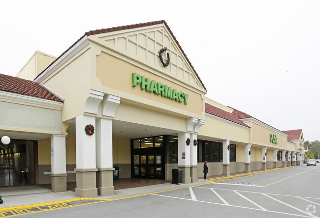
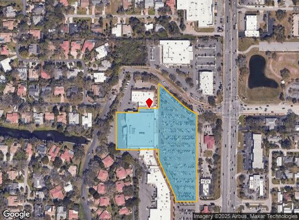
4836 S Tamiami Trl
North Port-Sarasota-Bradenton, FL
Landings Shopping Center The
0077-16-0026
PARCEL 2 LANDINGS SHOPPING CENTER, SUBJ TO 4844 C-SF UTILITY ESMT PER ORI 2022190891
Regionalshoppingcenterormallwithanchorstore
Sarasota
X
Florida
12115C0141G
2
2023
5.84 AC
2024
Sarasota
001801
Tampa/St Petersburg
55,861 SF
DEMOGRAPHICS near 4836 S Tamiami Trl
1 Mile
3 Mile
5 Mile
2024 Total Population
6,245
65,157
151,834
2029 Population
7,185
75,676
175,424
Pop Growth 2024-2029
+ 15.05%
+ 16.14%
+ 15.54%
Average Age
49
51
50
2024 Total Households
2,877
31,179
71,559
HH Growth 2024-2029
+ 15.09%
+ 16.35%
+ 15.79%
Median Household Inc
$79,308
$75,852
$73,374
Avg Household Size
2.10
2.00
2.00
2024 Avg HH Vehicles
2.00
2.00
2.00
Median Home Value
$508,005
$413,078
$378,818
Median Year Built
1977
1974
1978
Nearby Places
- Restaurants
- Banks
- Shops
- Fitness
- Groceries
PUBLIC TRANSPORTATION
AIRPORT
Sarasota/Bradenton International
DRIVE
WALK
Distance
Sarasota/Bradenton International
18 min
9.1 mi
Freight Ports
Port Manatee
DRIVE
WALK
Distance
Port Manatee
45 min
27.0 mi
Nearby Properties
Address
Land Use
TOTAL SIZE
Lot Size
Zoning
Address
Land Use
TOTAL SIZE
Lot Size
Zoning
2,010,667 SF
14.38 AC
SMH
Address
Land Use
TOTAL SIZE
Lot Size
Zoning
595,745 SF
42.33 AC
GU
Address
Land Use
TOTAL SIZE
Lot Size
Zoning
437,836 SF
72.05 AC
GU
Address
Land Use
TOTAL SIZE
Lot Size
Zoning
91,324 SF
2.18 AC
SMH
Address
Land Use
TOTAL SIZE
Lot Size
Zoning
11,781 SF
43.95 AC
GU
Address
Land Use
TOTAL SIZE
Lot Size
Zoning
146,948 SF
1.08 AC
SMH
Address
Land Use
TOTAL SIZE
Lot Size
Zoning
296,092 SF
38.78 AC
G
Address
Land Use
TOTAL SIZE
Lot Size
Zoning
287,086 SF
44.66 AC
G
Address
Land Use
TOTAL SIZE
Lot Size
Zoning
332,822 SF
34.74 AC
CG
Address
Land Use
TOTAL SIZE
Lot Size
Zoning
157,854 SF
8.32 AC
OPI
Address
Land Use
TOTAL SIZE
Lot Size
Zoning
2,430 SF
152 AC
G
Address
Land Use
TOTAL SIZE
Lot Size
Zoning
133,389 SF
6.14 AC
WFR
Address
Land Use
TOTAL SIZE
Lot Size
Zoning
150,433 SF
10.55 AC
RMF4
Address
Land Use
TOTAL SIZE
Lot Size
Zoning
223,929 SF
28.24 AC
RMF1
Address
Land Use
TOTAL SIZE
Lot Size
Zoning
233,075 SF
19.49 AC
RMF2
Address
Land Use
TOTAL SIZE
Lot Size
Zoning
48,427 SF
3.80 AC
CSCC
Address
Land Use
TOTAL SIZE
Lot Size
Zoning
133,430 SF
19.60 AC
GU
Address
Land Use
TOTAL SIZE
Lot Size
Zoning
138,823 SF
14.31 AC
CG
Address
Land Use
TOTAL SIZE
Lot Size
Zoning
376,559 SF
26.52 AC
CSC
Address
Land Use
TOTAL SIZE
Lot Size
Zoning
169,348 SF
19.36 AC
G
Address
Land Use
TOTAL SIZE
Lot Size
Zoning
300,601 SF
1.93 AC
SMH
Address
Land Use
TOTAL SIZE
Lot Size
Zoning
146,339 SF
12.54 AC
CG
Address
Land Use
TOTAL SIZE
Lot Size
Zoning
421,582 SF
2.09 AC
SMH
Address
Land Use
TOTAL SIZE
Lot Size
Zoning
96,425 SF
8.59 AC
OPI
Address
Land Use
TOTAL SIZE
Lot Size
Zoning
73,810 SF
3.98 AC
WFR
Address
Land Use
TOTAL SIZE
Lot Size
Zoning
77,568 SF
19 AC
RSF3
Address
Land Use
TOTAL SIZE
Lot Size
Zoning
139,974 SF
6.07 AC
RMF4
Address
Land Use
TOTAL SIZE
Lot Size
Zoning
123,873 SF
24.40 AC
GU
Address
Land Use
TOTAL SIZE
Lot Size
Zoning
184,766 SF
12.70 AC
RMF3
Address
Land Use
TOTAL SIZE
Lot Size
Zoning
115,041 SF
13.18 AC
GU
The World's #1 Commercial Real Estate Marketplace
Connect with us
© 2025 CoStar Group
The information above has been obtained from sources believed reliable. While we do not doubt its accuracy we have not verified it and make no guarantee, warranty or representation about it. It is your responsibility to independently confirm its accuracy and completeness. Any projections, opinions, assumptions, or estimates used are for example only and do not represent the current or future performance of the property. The value of this transaction to you depends on tax and other factors which should be evaluated by your tax, financial, and legal advisors. You and your advisors should conduct a careful, independent investigation of the property to determine to your satisfaction the suitability of the property for your needs.