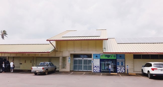
Property Record
484 Kuhio Hwy, Kapaa, HI 96746
Current Lease Availabilities
NEARBY LISTINGS FOR SALE OR LEASE
Property Detail
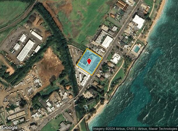
484 Kuhio Hwy
Kapaa, HI
Kapaa Town Lts
4-4-5-012-036-0000
LOT 15-A LP GR 5947 LP GR 5948 56472 SF DES
Commercialnec
Kauai
AE
Hawaii
1500020204F
15-a
2024
1.30 AC
2025
Kauai
040302
Hawaii
18,271 SF
DEMOGRAPHICS near 484 Kuhio Hwy
1 Mile
3 Mile
5 Mile
2024 Total Population
3,812
13,497
22,510
2029 Population
3,851
13,644
22,593
Pop Growth 2024-2029
+ 1.02%
+ 1.09%
+ 0.37%
Average Age
41
42
42
2024 Total Households
1,235
4,547
7,498
HH Growth 2024-2029
+ 0.81%
+ 0.92%
+ 0.13%
Median Household Inc
$92,891
$82,179
$85,329
Avg Household Size
2.90
2.90
2.90
2024 Avg HH Vehicles
2.00
2.00
2.00
Median Home Value
$689,655
$702,030
$725,933
Median Year Built
1983
1982
1983
Nearby Places
Map Layers
Map Styles
 Street
 Aerial
- Restaurants
- Banks
- Shops
- Fitness
- Groceries
PUBLIC TRANSPORTATION
AIRPORT
Lihue
DRIVE
WALK
Distance
Lihue
29 min
10.4 mi
Nearby Properties
Address
Land Use
TOTAL SIZE
Lot Size
Zoning
Address
Land Use
TOTAL SIZE
Lot Size
Zoning
169,787 SF
10.38 AC
RR-20
Address
Land Use
TOTAL SIZE
Lot Size
Zoning
70,444 SF
8.78 AC
C-N
Address
Land Use
TOTAL SIZE
Lot Size
Zoning
109,332 SF
8.59 AC
RR-20
Address
Land Use
TOTAL SIZE
Lot Size
Zoning
96,960 SF
4.89 AC
C-G
Address
Land Use
TOTAL SIZE
Lot Size
Zoning
53,510 SF
7.56 AC
RR-20
Address
Land Use
TOTAL SIZE
Lot Size
Zoning
88,880 SF
5.01 AC
RR-20
Address
Land Use
TOTAL SIZE
Lot Size
Zoning
12.57 AC
RR-20
Address
Land Use
TOTAL SIZE
Lot Size
Zoning
52,738 SF
4.27 AC
C-G
Address
Land Use
TOTAL SIZE
Lot Size
Zoning
17,557 SF
4 AC
O
Address
Land Use
TOTAL SIZE
Lot Size
Zoning
42,300 SF
4.23 AC
C-G
Address
Land Use
TOTAL SIZE
Lot Size
Zoning
16.55 AC
A
Address
Land Use
TOTAL SIZE
Lot Size
Zoning
27,700 SF
1.52 AC
RR-20
Address
Land Use
TOTAL SIZE
Lot Size
Zoning
4.11 AC
R-10/ST-P
Address
Land Use
TOTAL SIZE
Lot Size
Zoning
18,524 SF
3.06 AC
C-G
Address
Land Use
TOTAL SIZE
Lot Size
Zoning
10.81 AC
RR-20
Address
Land Use
TOTAL SIZE
Lot Size
Zoning
10 AC
RR-20
Address
Land Use
TOTAL SIZE
Lot Size
Zoning
11.78 AC
RR-20
Address
Land Use
TOTAL SIZE
Lot Size
Zoning
15,660 SF
8 AC
I-L
Address
Land Use
TOTAL SIZE
Lot Size
Zoning
10.37 AC
I-L
Address
Land Use
TOTAL SIZE
Lot Size
Zoning
2.06 AC
RR-20
Address
Land Use
TOTAL SIZE
Lot Size
Zoning
31,536 SF
3.16 AC
I-L
Address
Land Use
TOTAL SIZE
Lot Size
Zoning
11,780 SF
3.43 AC
I-L
Address
Land Use
TOTAL SIZE
Lot Size
Zoning
6.79 AC
A
Address
Land Use
TOTAL SIZE
Lot Size
Zoning
1,941 SF
156.87 AC
A
Address
Land Use
TOTAL SIZE
Lot Size
Zoning
17,568 SF
0.89 AC
C-G
Address
Land Use
TOTAL SIZE
Lot Size
Zoning
15,967 SF
0.82 AC
SPA-A
Address
Land Use
TOTAL SIZE
Lot Size
Zoning
21,746 SF
0.34 AC
C-G
Address
Land Use
TOTAL SIZE
Lot Size
Zoning
12,461 SF
1.30 AC
C-N
Address
Land Use
TOTAL SIZE
Lot Size
Zoning
16,521 SF
0.79 AC
C-G
The World's #1 Commercial Real Estate Marketplace
Connect with us
© 2026 CoStar Group
The information above has been obtained from sources believed reliable. While we do not doubt its accuracy we have not verified it and make no guarantee, warranty or representation about it. It is your responsibility to independently confirm its accuracy and completeness. Any projections, opinions, assumptions, or estimates used are for example only and do not represent the current or future performance of the property. The value of this transaction to you depends on tax and other factors which should be evaluated by your tax, financial, and legal advisors. You and your advisors should conduct a careful, independent investigation of the property to determine to your satisfaction the suitability of the property for your needs.