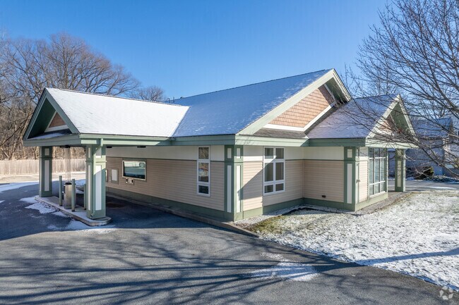
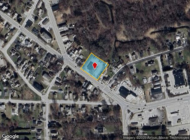
Property Record
484 Main St, West Rutland, VT 05777

NEARBY LISTINGS FOR SALE OR LEASE
-
-
View all West Rutland listings for sale on LoopNet.com
Property Detail
484 Main St
735-234-10323
334 BANK BLDG
Financialbuilding
Rutland
X
Vermont
50021C0381D
0.70 AC
2024
Vermont South Area
2024
Other Market Areas
963500
Rutland, VT
2,144 SF
DEMOGRAPHICS near 484 Main St
1 Mile
3 Mile
5 Mile
2024 Total Population
1,382
3,934
21,325
2029 Population
1,338
3,848
21,066
Pop Growth 2024-2029
(3.18%)
(2.19%)
(1.21%)
Average Age
44
44
45
2024 Total Households
614
1,726
9,738
HH Growth 2024-2029
(3.26%)
(2.14%)
(1.21%)
Median Household Inc
$52,388
$64,175
$56,119
Avg Household Size
2.20
2.10
2.00
2024 Avg HH Vehicles
2.00
2.00
2.00
Median Home Value
$160,641
$167,174
$170,854
Median Year Built
1948
1956
1951
Nearby Places
- Restaurants
- Banks
- Shops
- Fitness
- Groceries
PUBLIC TRANSPORTATION
COMMUTER RAIL
Rutland (Ethan Allen Express - Amtrak)
DRIVE
WALK
Distance
Rutland (Ethan Allen Express - Amtrak)
8 min
3.8 mi
Castleton Amtrak Station (Ethan Allen Express - Amtrak)
DRIVE
WALK
Distance
Castleton Amtrak Station (Ethan Allen Express - Amtrak)
10 min
8.3 mi
Freight Ports
Albany, NY Port
DRIVE
WALK
Distance
Albany, NY Port
135 min
98.7 mi
SALE & LEASE HISTORY
LISTING DATE
SALE/LEASE

Nov 30, 2021
For Sale
Nearby Properties
Address
Land Use
TOTAL SIZE
Lot Size
Zoning
Address
Land Use
TOTAL SIZE
Lot Size
Zoning
67,077 SF
19.10 AC
VR
Address
Land Use
TOTAL SIZE
Lot Size
Zoning
6.61 AC
Address
Land Use
TOTAL SIZE
Lot Size
Zoning
269.48 AC
Address
Land Use
TOTAL SIZE
Lot Size
Zoning
2.47 AC
Address
Land Use
TOTAL SIZE
Lot Size
Zoning
46,200 SF
26.41 AC
VC2
Address
Land Use
TOTAL SIZE
Lot Size
Zoning
11,139 SF
1.31 AC
VC2
Address
Land Use
TOTAL SIZE
Lot Size
Zoning
87.87 AC
Address
Land Use
TOTAL SIZE
Lot Size
Zoning
Address
Land Use
TOTAL SIZE
Lot Size
Zoning
20.52 AC
Address
Land Use
TOTAL SIZE
Lot Size
Zoning
Address
Land Use
TOTAL SIZE
Lot Size
Zoning
5,145 SF
1.32 AC
VC2
Address
Land Use
TOTAL SIZE
Lot Size
Zoning
13.80 AC
Address
Land Use
TOTAL SIZE
Lot Size
Zoning
1.60 AC
R1
Address
Land Use
TOTAL SIZE
Lot Size
Zoning
44,125 SF
3.60 AC
Address
Land Use
TOTAL SIZE
Lot Size
Zoning
9,456 SF
0.56 AC
VC1
Address
Land Use
TOTAL SIZE
Lot Size
Zoning
1,826 AC
Address
Land Use
TOTAL SIZE
Lot Size
Zoning
5.38 AC
Address
Land Use
TOTAL SIZE
Lot Size
Zoning
Address
Land Use
TOTAL SIZE
Lot Size
Zoning
9,437 SF
0.70 AC
VC1
Address
Land Use
TOTAL SIZE
Lot Size
Zoning
1,170 SF
6.20 AC
R2A
Address
Land Use
TOTAL SIZE
Lot Size
Zoning
7,200 SF
25.20 AC
Address
Land Use
TOTAL SIZE
Lot Size
Zoning
27.01 AC
Address
Land Use
TOTAL SIZE
Lot Size
Zoning
299.17 AC
Address
Land Use
TOTAL SIZE
Lot Size
Zoning
21,828 SF
4.60 AC
Address
Land Use
TOTAL SIZE
Lot Size
Zoning
4,800 SF
6.88 AC
CM
Address
Land Use
TOTAL SIZE
Lot Size
Zoning
67.56 AC
Address
Land Use
TOTAL SIZE
Lot Size
Zoning
4,690 SF
0.97 AC
VR
Address
Land Use
TOTAL SIZE
Lot Size
Zoning
3.88 AC
CM
Address
Land Use
TOTAL SIZE
Lot Size
Zoning
3.94 AC
The World's #1 Commercial Real Estate Marketplace
Connect with us
© 2025 CoStar Group
The information above has been obtained from sources believed reliable. While we do not doubt its accuracy we have not verified it and make no guarantee, warranty or representation about it. It is your responsibility to independently confirm its accuracy and completeness. Any projections, opinions, assumptions, or estimates used are for example only and do not represent the current or future performance of the property. The value of this transaction to you depends on tax and other factors which should be evaluated by your tax, financial, and legal advisors. You and your advisors should conduct a careful, independent investigation of the property to determine to your satisfaction the suitability of the property for your needs.