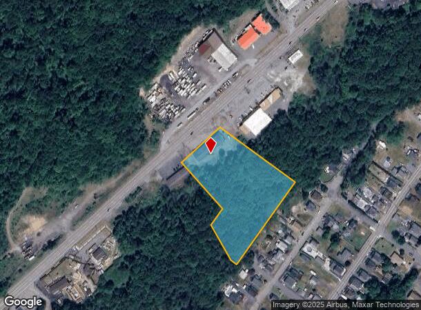
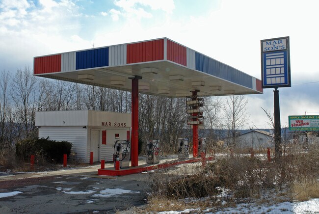
Property Record
484 Route 6 Hwy E, Jermyn, PA 18433

NEARBY LISTINGS FOR SALE OR LEASE
Property Detail
484 Route 6 Hwy E
Scranton--Wilkes-Barre--Hazelton, PA
Lands Of Forgion
0730202000201
3.00A 398X422X30X173X81X261X221 LANDS OF FORGIONE PARCEL 1 W-02 B-020 L-019
Taxexempt
Lackawanna
X
Pennsylvania
42069C0141D
19
2025
3 AC
2025
I-81 Corridor
110600
Philadelphia
DEMOGRAPHICS near 484 Route 6 Hwy E
1 Mile
3 Mile
5 Mile
2024 Total Population
3,484
9,830
34,630
2029 Population
3,435
9,780
34,311
Pop Growth 2024-2029
(1.41%)
(0.51%)
(0.92%)
Average Age
43
43
43
2024 Total Households
1,542
4,194
14,745
HH Growth 2024-2029
(1.49%)
(0.55%)
(0.94%)
Median Household Inc
$66,107
$64,559
$60,966
Avg Household Size
2.20
2.30
2.30
2024 Avg HH Vehicles
2.00
2.00
2.00
Median Home Value
$151,495
$161,318
$163,785
Median Year Built
1948
1953
1954
Nearby Places
Map Layers
Map Styles
 Street
 Aerial
- Restaurants
- Banks
- Shops
- Fitness
- Groceries
PUBLIC TRANSPORTATION
AIRPORT
Wilkes-Barre/Scranton International
DRIVE
WALK
Distance
Wilkes-Barre/Scranton International
32 min
22.8 mi
Freight Ports
Maher Terminal
DRIVE
WALK
Distance
Maher Terminal
155 min
123.4 mi
Nearby Properties
Address
Land Use
TOTAL SIZE
Lot Size
Zoning
Address
Land Use
TOTAL SIZE
Lot Size
Zoning
15.04 AC
Address
Land Use
TOTAL SIZE
Lot Size
Zoning
44.05 AC
Address
Land Use
TOTAL SIZE
Lot Size
Zoning
Address
Land Use
TOTAL SIZE
Lot Size
Zoning
18.61 AC
Address
Land Use
TOTAL SIZE
Lot Size
Zoning
2,428 SF
357.58 AC
Address
Land Use
TOTAL SIZE
Lot Size
Zoning
13.40 AC
Address
Land Use
TOTAL SIZE
Lot Size
Zoning
Address
Land Use
TOTAL SIZE
Lot Size
Zoning
11.67 AC
Address
Land Use
TOTAL SIZE
Lot Size
Zoning
0.95 AC
Address
Land Use
TOTAL SIZE
Lot Size
Zoning
12.02 AC
Address
Land Use
TOTAL SIZE
Lot Size
Zoning
3.78 AC
Address
Land Use
TOTAL SIZE
Lot Size
Zoning
2.89 AC
Address
Land Use
TOTAL SIZE
Lot Size
Zoning
13.38 AC
Address
Land Use
TOTAL SIZE
Lot Size
Zoning
4.62 AC
Address
Land Use
TOTAL SIZE
Lot Size
Zoning
Address
Land Use
TOTAL SIZE
Lot Size
Zoning
172.35 AC
Address
Land Use
TOTAL SIZE
Lot Size
Zoning
Address
Land Use
TOTAL SIZE
Lot Size
Zoning
Address
Land Use
TOTAL SIZE
Lot Size
Zoning
1.22 AC
Address
Land Use
TOTAL SIZE
Lot Size
Zoning
8.55 AC
Address
Land Use
TOTAL SIZE
Lot Size
Zoning
Address
Land Use
TOTAL SIZE
Lot Size
Zoning
Address
Land Use
TOTAL SIZE
Lot Size
Zoning
0.35 AC
Address
Land Use
TOTAL SIZE
Lot Size
Zoning
2.26 AC
Address
Land Use
TOTAL SIZE
Lot Size
Zoning
Address
Land Use
TOTAL SIZE
Lot Size
Zoning
Address
Land Use
TOTAL SIZE
Lot Size
Zoning
Address
Land Use
TOTAL SIZE
Lot Size
Zoning
510.20 AC
Address
Land Use
TOTAL SIZE
Lot Size
Zoning
4.17 AC
Address
Land Use
TOTAL SIZE
Lot Size
Zoning
2.36 AC
The World's #1 Commercial Real Estate Marketplace
Connect with us
© 2025 CoStar Group
The information above has been obtained from sources believed reliable. While we do not doubt its accuracy we have not verified it and make no guarantee, warranty or representation about it. It is your responsibility to independently confirm its accuracy and completeness. Any projections, opinions, assumptions, or estimates used are for example only and do not represent the current or future performance of the property. The value of this transaction to you depends on tax and other factors which should be evaluated by your tax, financial, and legal advisors. You and your advisors should conduct a careful, independent investigation of the property to determine to your satisfaction the suitability of the property for your needs.