Property Record
4840 Crain Hwy, White Plains, MD 20695
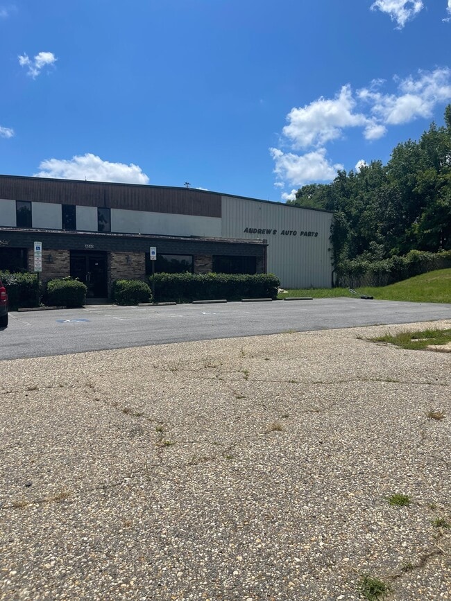

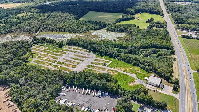
This Property Is For Sale
Current Lease Availabilities
NEARBY LISTINGS FOR SALE OR LEASE
Property Detail
4840 Crain Hwy
06-134734
Town Of La Plata
Warehouse
26.564 AC S S RT 301
X
Charles
24017C0180C
Maryland
2025
26.56 AC
2025
Charles County
851004
Washington, DC
12,044 SF
Washington-Arlington-Alexandria, DC-VA-MD-WV
DEMOGRAPHICS near 4840 Crain Hwy
1 Mile
3 Mile
5 Mile
2024 Total Population
1,022
36,411
96,954
2029 Population
1,069
38,181
101,468
Pop Growth 2024-2029
+ 4.60%
+ 4.86%
+ 4.66%
Average Age
43
38
38
2024 Total Households
372
12,958
34,232
HH Growth 2024-2029
+ 4.84%
+ 4.85%
+ 4.64%
Median Household Inc
$102,273
$108,515
$107,875
Avg Household Size
2.70
2.70
2.80
2024 Avg HH Vehicles
2.00
2.00
2.00
Median Home Value
$356,874
$369,781
$369,432
Median Year Built
1984
2001
1993
Nearby Places
Map Layers
Map Styles
 Street
 Aerial
- Restaurants
- Banks
- Shops
- Fitness
- Groceries
PUBLIC TRANSPORTATION
AIRPORT
Ronald Reagan Washington Ntl
DRIVE
WALK
Distance
Ronald Reagan Washington Ntl
51 min
31.3 mi
Freight Ports
Port of Baltimore
DRIVE
WALK
Distance
Port of Baltimore
85 min
57.8 mi
Nearby Properties
Address
Land Use
TOTAL SIZE
Lot Size
Zoning
Address
Land Use
TOTAL SIZE
Lot Size
Zoning
714,134 SF
29.53 AC
PUD
Address
Land Use
TOTAL SIZE
Lot Size
Zoning
289,883 SF
98.95 AC
PUD
Address
Land Use
TOTAL SIZE
Lot Size
Zoning
287,760 SF
16.27 AC
PUD
Address
Land Use
TOTAL SIZE
Lot Size
Zoning
250,272 SF
12.37 AC
PUD
Address
Land Use
TOTAL SIZE
Lot Size
Zoning
267,264 SF
26.49 AC
PUD
Address
Land Use
TOTAL SIZE
Lot Size
Zoning
239,608 SF
11.28 AC
PUD
Address
Land Use
TOTAL SIZE
Lot Size
Zoning
392,124 SF
38.73 AC
PUD
Address
Land Use
TOTAL SIZE
Lot Size
Zoning
315,662 SF
134.30 AC
PL
Address
Land Use
TOTAL SIZE
Lot Size
Zoning
103,737 SF
43.94 AC
WCD
Address
Land Use
TOTAL SIZE
Lot Size
Zoning
136,192 SF
17.85 AC
PUD
Address
Land Use
TOTAL SIZE
Lot Size
Zoning
113,605 SF
20.59 AC
CH
Address
Land Use
TOTAL SIZE
Lot Size
Zoning
141,578 SF
7.40 AC
PUD
Address
Land Use
TOTAL SIZE
Lot Size
Zoning
112,736 SF
16.71 AC
PUD
Address
Land Use
TOTAL SIZE
Lot Size
Zoning
80,682 SF
11.35 AC
C-H
Address
Land Use
TOTAL SIZE
Lot Size
Zoning
121,968 SF
2.23 AC
PUD
Address
Land Use
TOTAL SIZE
Lot Size
Zoning
53,318 SF
20.01 AC
PUD
Address
Land Use
TOTAL SIZE
Lot Size
Zoning
147,800 SF
4.54 AC
RH
Address
Land Use
TOTAL SIZE
Lot Size
Zoning
116,828 SF
10.78 AC
PUD
Address
Land Use
TOTAL SIZE
Lot Size
Zoning
126,240 SF
3.52 AC
RH
Address
Land Use
TOTAL SIZE
Lot Size
Zoning
123,290 SF
8.25 AC
PUD
Address
Land Use
TOTAL SIZE
Lot Size
Zoning
53,638 SF
3.76 AC
MUD-3
Address
Land Use
TOTAL SIZE
Lot Size
Zoning
129,001 SF
11.64 AC
C-H
Address
Land Use
TOTAL SIZE
Lot Size
Zoning
41,004 SF
3.97 AC
RM
Address
Land Use
TOTAL SIZE
Lot Size
Zoning
15.22 AC
TDX
Address
Land Use
TOTAL SIZE
Lot Size
Zoning
166,188 SF
27.99 AC
IG
Address
Land Use
TOTAL SIZE
Lot Size
Zoning
98,545 SF
6.26 AC
RH
Address
Land Use
TOTAL SIZE
Lot Size
Zoning
137,862 SF
18.10 AC
CH
Address
Land Use
TOTAL SIZE
Lot Size
Zoning
44,510 SF
5.53 AC
PUD
Address
Land Use
TOTAL SIZE
Lot Size
Zoning
35,976 SF
3.97 AC
CH
Address
Land Use
TOTAL SIZE
Lot Size
Zoning
62,127 SF
37.47 AC
PL
The World's #1 Commercial Real Estate Marketplace
Connect with us
© 2025 CoStar Group
The information above has been obtained from sources believed reliable. While we do not doubt its accuracy we have not verified it and make no guarantee, warranty or representation about it. It is your responsibility to independently confirm its accuracy and completeness. Any projections, opinions, assumptions, or estimates used are for example only and do not represent the current or future performance of the property. The value of this transaction to you depends on tax and other factors which should be evaluated by your tax, financial, and legal advisors. You and your advisors should conduct a careful, independent investigation of the property to determine to your satisfaction the suitability of the property for your needs.