Property Record
4840 Crisfield Hwy, Crisfield, MD 21817

NEARBY LISTINGS FOR SALE OR LEASE
-
-
View all Crisfield listings for sale on LoopNet.com
Property Detail
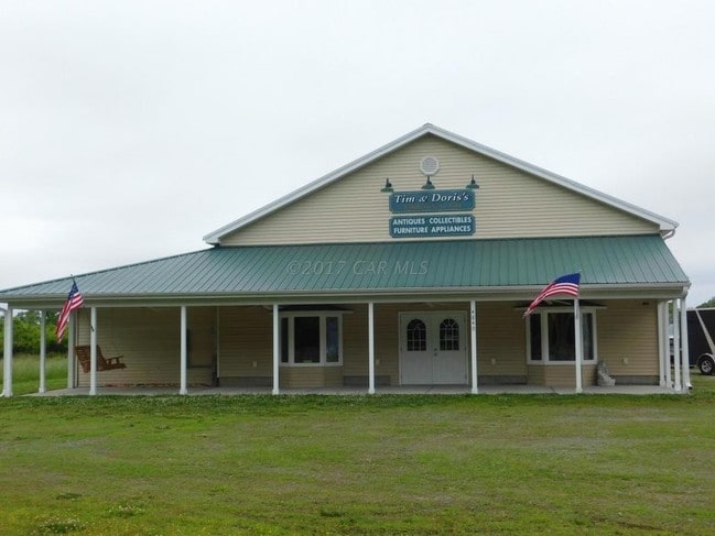
4840 Crisfield Hwy
08-160872
Park Sub
Warehouse
2.00 AC-LT 2-PL15/72 NW/SD CRISFIELD HWY WARD'S PARK SUBDIVISION
AE
Somerset
24039C0295F
Maryland
2025
2
2025
2 AC
930500
Other Market Areas
3,360 SF
Salisbury, MD-DE
DEMOGRAPHICS near 4840 Crisfield Hwy
1 Mile
3 Mile
5 Mile
2024 Total Population
461
3,344
6,400
2029 Population
451
3,300
6,391
Pop Growth 2024-2029
(2.17%)
(1.32%)
(0.14%)
Average Age
47
45
44
2024 Total Households
193
1,369
2,700
HH Growth 2024-2029
(2.59%)
(1.53%)
(0.30%)
Median Household Inc
$71,612
$54,047
$48,914
Avg Household Size
2.30
2.30
2.30
2024 Avg HH Vehicles
2.00
2.00
2.00
Median Home Value
$220,000
$156,111
$132,176
Median Year Built
1981
1978
1976
Nearby Places
Map Layers
Map Styles
 Street
 Aerial
- Restaurants
- Banks
- Shops
- Fitness
- Groceries
PUBLIC TRANSPORTATION
AIRPORT
Salisbury-Ocean City Wicomico Regional
DRIVE
WALK
Distance
Salisbury-Ocean City Wicomico Regional
48 min
32.4 mi
Freight Ports
Virginia Port Authority - Newport News
DRIVE
WALK
Distance
Virginia Port Authority - Newport News
193 min
136.5 mi
SALE & LEASE HISTORY
LISTING DATE
SALE/LEASE

Oct 12, 2017
For Sale
Feb 06, 2019
For Sale
Nearby Properties
Address
Land Use
TOTAL SIZE
Lot Size
Zoning
Address
Land Use
TOTAL SIZE
Lot Size
Zoning
57,905 SF
14.13 AC
MRC
Address
Land Use
TOTAL SIZE
Lot Size
Zoning
3,052.15 AC
R-1
Address
Land Use
TOTAL SIZE
Lot Size
Zoning
79,568 SF
12 AC
R-1
Address
Land Use
TOTAL SIZE
Lot Size
Zoning
24,891 SF
3.12 AC
C-2
Address
Land Use
TOTAL SIZE
Lot Size
Zoning
62,228 SF
10.68 AC
I-2
Address
Land Use
TOTAL SIZE
Lot Size
Zoning
9,350 SF
4.83 AC
C-3
Address
Land Use
TOTAL SIZE
Lot Size
Zoning
7,000 SF
15.15 AC
A
Address
Land Use
TOTAL SIZE
Lot Size
Zoning
20,914 SF
9.80 AC
R-1
Address
Land Use
TOTAL SIZE
Lot Size
Zoning
4,640 SF
10 AC
T-M
Address
Land Use
TOTAL SIZE
Lot Size
Zoning
6,900 SF
11.54 AC
A
Address
Land Use
TOTAL SIZE
Lot Size
Zoning
7,943 SF
3.15 AC
Address
Land Use
TOTAL SIZE
Lot Size
Zoning
1.03 AC
T-M
Address
Land Use
TOTAL SIZE
Lot Size
Zoning
1,200 SF
2 AC
C-3
Address
Land Use
TOTAL SIZE
Lot Size
Zoning
3,744 SF
0.59 AC
R-1
Address
Land Use
TOTAL SIZE
Lot Size
Zoning
3 AC
I1
Address
Land Use
TOTAL SIZE
Lot Size
Zoning
2,562 SF
2.50 AC
A
Address
Land Use
TOTAL SIZE
Lot Size
Zoning
4,512 SF
2 AC
C-3
Address
Land Use
TOTAL SIZE
Lot Size
Zoning
3,180 SF
0.96 AC
C-2
Address
Land Use
TOTAL SIZE
Lot Size
Zoning
3,000 SF
4 AC
C-2
Address
Land Use
TOTAL SIZE
Lot Size
Zoning
34,758 SF
6.18 AC
R-1
Address
Land Use
TOTAL SIZE
Lot Size
Zoning
1,152 SF
12 AC
A
Address
Land Use
TOTAL SIZE
Lot Size
Zoning
2,622 SF
0.91 AC
C-2
Address
Land Use
TOTAL SIZE
Lot Size
Zoning
2,880 SF
0.52 AC
R-1
Address
Land Use
TOTAL SIZE
Lot Size
Zoning
5,742 SF
1.52 AC
R-2
Address
Land Use
TOTAL SIZE
Lot Size
Zoning
492 SF
3.61 AC
AP
Address
Land Use
TOTAL SIZE
Lot Size
Zoning
10,545 SF
2.14 AC
R-2
Address
Land Use
TOTAL SIZE
Lot Size
Zoning
2,232 SF
1.05 AC
C-2
Address
Land Use
TOTAL SIZE
Lot Size
Zoning
3,360 SF
5.26 AC
I-1
Address
Land Use
TOTAL SIZE
Lot Size
Zoning
825 SF
3.93 AC
MRC
Address
Land Use
TOTAL SIZE
Lot Size
Zoning
70,321 SF
23.35 AC
I-1
The World's #1 Commercial Real Estate Marketplace
Connect with us
© 2025 CoStar Group
The information above has been obtained from sources believed reliable. While we do not doubt its accuracy we have not verified it and make no guarantee, warranty or representation about it. It is your responsibility to independently confirm its accuracy and completeness. Any projections, opinions, assumptions, or estimates used are for example only and do not represent the current or future performance of the property. The value of this transaction to you depends on tax and other factors which should be evaluated by your tax, financial, and legal advisors. You and your advisors should conduct a careful, independent investigation of the property to determine to your satisfaction the suitability of the property for your needs.