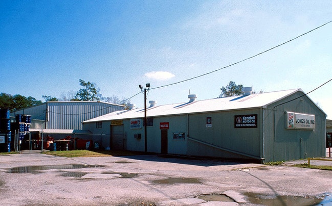
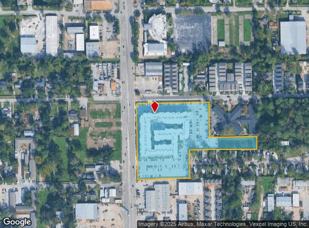
Property Record
4840 N Shepherd Dr, Houston, TX 77018
NEARBY LISTINGS FOR SALE OR LEASE
Property Detail
4840 N Shepherd Dr
1177870010001
Ibiza Shepherd Garden Oaks
Outdoorrecreationbeachmountaindesert
RES A BLK 1 IBIZA SHEPHERD GARDEN OAKS
X
Harris
48201C0660M
Texas
2024
5.69 AC
2025
Northwest Near
530600
Houston
279,452 SF
Houston-The Woodlands-Sugar Land, TX
DEMOGRAPHICS near 4840 N Shepherd Dr
1 Mile
3 Mile
5 Mile
2024 Total Population
16,088
144,453
387,589
2029 Population
16,833
149,187
399,718
Pop Growth 2024-2029
+ 4.63%
+ 3.28%
+ 3.13%
Average Age
38
37
36
2024 Total Households
6,186
55,564
148,430
HH Growth 2024-2029
+ 4.64%
+ 3.40%
+ 3.39%
Median Household Inc
$48,124
$60,539
$62,511
Avg Household Size
2.50
2.50
2.50
2024 Avg HH Vehicles
2.00
2.00
2.00
Median Home Value
$378,920
$368,276
$325,240
Median Year Built
1968
1973
1977
Nearby Places
Map Layers
Map Styles
 Street
 Aerial
- Restaurants
- Banks
- Shops
- Fitness
- Groceries
PUBLIC TRANSPORTATION
COMMUTER RAIL
Houston (Sunset Limited - Amtrak)
DRIVE
WALK
Distance
Houston (Sunset Limited - Amtrak)
13 min
6.4 mi
AIRPORT
George Bush Intcntl/Houston
DRIVE
WALK
Distance
George Bush Intcntl/Houston
22 min
15.0 mi
William P Hobby
DRIVE
WALK
Distance
William P Hobby
33 min
19.8 mi
Freight Ports
Port of Houston
DRIVE
WALK
Distance
Port of Houston
25 min
15.4 mi
Nearby Properties
Address
Land Use
TOTAL SIZE
Lot Size
Zoning
Address
Land Use
TOTAL SIZE
Lot Size
Zoning
453,456 SF
3.11 AC
Address
Land Use
TOTAL SIZE
Lot Size
Zoning
519,374 SF
6.18 AC
Address
Land Use
TOTAL SIZE
Lot Size
Zoning
563,626 SF
4.71 AC
Address
Land Use
TOTAL SIZE
Lot Size
Zoning
474,326 SF
43.16 AC
Address
Land Use
TOTAL SIZE
Lot Size
Zoning
432,691 SF
3.26 AC
Address
Land Use
TOTAL SIZE
Lot Size
Zoning
261,312 SF
1.81 AC
Address
Land Use
TOTAL SIZE
Lot Size
Zoning
457,647 SF
2.30 AC
Address
Land Use
TOTAL SIZE
Lot Size
Zoning
593,265 SF
3.73 AC
Address
Land Use
TOTAL SIZE
Lot Size
Zoning
379,725 SF
2.84 AC
Address
Land Use
TOTAL SIZE
Lot Size
Zoning
587,156 SF
4.40 AC
Address
Land Use
TOTAL SIZE
Lot Size
Zoning
440,577 SF
4.13 AC
Address
Land Use
TOTAL SIZE
Lot Size
Zoning
270,845 SF
10.75 AC
Address
Land Use
TOTAL SIZE
Lot Size
Zoning
443,228 SF
3.15 AC
Address
Land Use
TOTAL SIZE
Lot Size
Zoning
87,179 SF
4.13 AC
Address
Land Use
TOTAL SIZE
Lot Size
Zoning
322,880 SF
2.61 AC
Address
Land Use
TOTAL SIZE
Lot Size
Zoning
402,433 SF
2.77 AC
Address
Land Use
TOTAL SIZE
Lot Size
Zoning
263,475 SF
7.90 AC
Address
Land Use
TOTAL SIZE
Lot Size
Zoning
280,241 SF
1.90 AC
Address
Land Use
TOTAL SIZE
Lot Size
Zoning
198,770 SF
2.10 AC
Address
Land Use
TOTAL SIZE
Lot Size
Zoning
228,804 SF
3.28 AC
Address
Land Use
TOTAL SIZE
Lot Size
Zoning
235,535 SF
1.71 AC
Address
Land Use
TOTAL SIZE
Lot Size
Zoning
276,332 SF
6.05 AC
Address
Land Use
TOTAL SIZE
Lot Size
Zoning
336,050 SF
14.41 AC
Address
Land Use
TOTAL SIZE
Lot Size
Zoning
178,094 SF
6.08 AC
Address
Land Use
TOTAL SIZE
Lot Size
Zoning
989,762 SF
6.10 AC
Address
Land Use
TOTAL SIZE
Lot Size
Zoning
545,628 SF
19.41 AC
Address
Land Use
TOTAL SIZE
Lot Size
Zoning
531,786 SF
17.60 AC
Address
Land Use
TOTAL SIZE
Lot Size
Zoning
197,696 SF
3.06 AC
Address
Land Use
TOTAL SIZE
Lot Size
Zoning
194,990 SF
16.36 AC
The World's #1 Commercial Real Estate Marketplace
Connect with us
© 2026 CoStar Group
The information above has been obtained from sources believed reliable. While we do not doubt its accuracy we have not verified it and make no guarantee, warranty or representation about it. It is your responsibility to independently confirm its accuracy and completeness. Any projections, opinions, assumptions, or estimates used are for example only and do not represent the current or future performance of the property. The value of this transaction to you depends on tax and other factors which should be evaluated by your tax, financial, and legal advisors. You and your advisors should conduct a careful, independent investigation of the property to determine to your satisfaction the suitability of the property for your needs.