Property Record
4841 Highway 35 N, Rockport, TX 78382


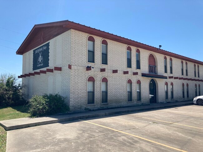
This Property Is For Sale
Property Detail
4841 Highway 35 N
R56154
A70 C O D GILLILAND, ACRES 1.02, (ADD'N IMPS)
Multifamilydwelling
ARANSAS
B and X Area of moderate flood hazard, usually the area between the limits of the 100-year and 500-year floods.
Texas
2025
1.02 AC
2025
Rockport/North Aransas County
950102
Corpus Christi
7,456 SF
Corpus Christi, TX
NEARBY LISTINGS FOR SALE OR LEASE
DEMOGRAPHICS near 4841 Highway 35 N
1 mile
3 mile
5 mile
2025 Total Population
582
3,601
13,575
2030 Population
570
3,546
14,326
Pop Growth 2025-2030
(2.06%)
(1.53%)
+ 5.53%
Average Age
54
51
51
2025 Total Households
300
1,739
6,184
HH Growth 2025-2030
(1.00%)
(0.69%)
+ 6.13%
Median Household Inc
$76,651
$71,317
$70,200
Avg Household Size
1.90
2.00
2.10
2025 Avg HH Vehicles
2.00
2.00
2.00
Median Home Value
$303,472
$286,548
$320,210
Median Year Built
1984
1997
1995
Nearby Places
Map Layers
Map Styles
 Street
 Aerial
Transit
 Traffic
 Biking
Places
Listings with unknown addresses are not visible on the map
- Restaurants
- Banks
- Shops
- Fitness
- Groceries
Nearby Properties
Address
Land Use
TOTAL SIZE
Lot Size
Zoning
Address
Land Use
TOTAL SIZE
Lot Size
Zoning
100,891 SF
7.78 AC
Address
Land Use
TOTAL SIZE
Lot Size
Zoning
125,197 SF
14.61 AC
Address
Land Use
TOTAL SIZE
Lot Size
Zoning
79,033 SF
649.69 AC
Address
Land Use
TOTAL SIZE
Lot Size
Zoning
288 SF
129.13 AC
Address
Land Use
TOTAL SIZE
Lot Size
Zoning
47,169 SF
85.55 AC
Address
Land Use
TOTAL SIZE
Lot Size
Zoning
33,524 SF
2.06 AC
Address
Land Use
TOTAL SIZE
Lot Size
Zoning
2,980 SF
47.98 AC
Address
Land Use
TOTAL SIZE
Lot Size
Zoning
91,025 SF
8.22 AC
Address
Land Use
TOTAL SIZE
Lot Size
Zoning
16,791 SF
2.65 AC
Address
Land Use
TOTAL SIZE
Lot Size
Zoning
14,925 SF
1.66 AC
Address
Land Use
TOTAL SIZE
Lot Size
Zoning
9,886 SF
7.96 AC
Address
Land Use
TOTAL SIZE
Lot Size
Zoning
12,072 SF
126.99 AC
Address
Land Use
TOTAL SIZE
Lot Size
Zoning
13,518 SF
1.82 AC
Address
Land Use
TOTAL SIZE
Lot Size
Zoning
2,739 SF
117.62 AC
Address
Land Use
TOTAL SIZE
Lot Size
Zoning
17,370 SF
10.10 AC
Address
Land Use
TOTAL SIZE
Lot Size
Zoning
70,416 SF
7.53 AC
Address
Land Use
TOTAL SIZE
Lot Size
Zoning
17,682 SF
1.51 AC
Address
Land Use
TOTAL SIZE
Lot Size
Zoning
65.49 AC
Address
Land Use
TOTAL SIZE
Lot Size
Zoning
44,530 SF
4.23 AC
Address
Land Use
TOTAL SIZE
Lot Size
Zoning
6,656 SF
17.80 AC
Address
Land Use
TOTAL SIZE
Lot Size
Zoning
41,130 SF
3.19 AC
Address
Land Use
TOTAL SIZE
Lot Size
Zoning
11,138 SF
2.72 AC
Address
Land Use
TOTAL SIZE
Lot Size
Zoning
146,800 SF
8.25 AC
Address
Land Use
TOTAL SIZE
Lot Size
Zoning
44,890 SF
4.21 AC
Address
Land Use
TOTAL SIZE
Lot Size
Zoning
84,929 SF
8.27 AC
Address
Land Use
TOTAL SIZE
Lot Size
Zoning
71,392 SF
5 AC
Address
Land Use
TOTAL SIZE
Lot Size
Zoning
3,830 SF
1.38 AC
Address
Land Use
TOTAL SIZE
Lot Size
Zoning
7,392 SF
5.52 AC
Address
Land Use
TOTAL SIZE
Lot Size
Zoning
5,805 SF
5.90 AC
Address
Land Use
TOTAL SIZE
Lot Size
Zoning
45,654 SF
8.25 AC
The World's #1 Commercial Real Estate Marketplace
Connect with us
© 2026 CoStar Group
The information above has been obtained from sources believed reliable. While we do not doubt its accuracy we have not verified it and make no guarantee, warranty or representation about it. It is your responsibility to independently confirm its accuracy and completeness. Any projections, opinions, assumptions, or estimates used are for example only and do not represent the current or future performance of the property. The value of this transaction to you depends on tax and other factors which should be evaluated by your tax, financial, and legal advisors. You and your advisors should conduct a careful, independent investigation of the property to determine to your satisfaction the suitability of the property for your needs.