Property Record
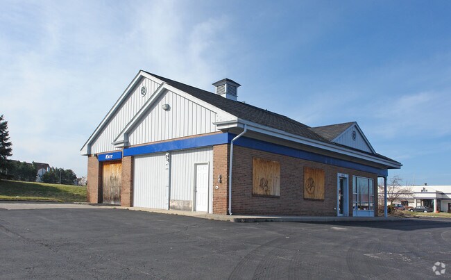
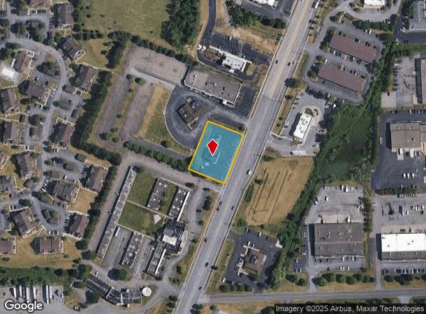
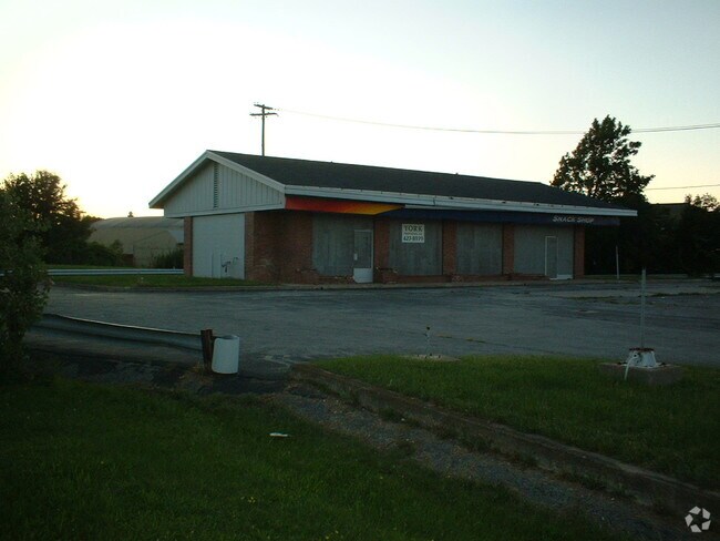
4843 W Henrietta Rd, Henrietta, NY 14467

NEARBY LISTINGS FOR SALE OR LEASE
Property Detail
4843 W Henrietta Rd
Rochester, NY
Portion Lot18
263200-175-030-0001-006-000
T LOT 18 5TH R 2319 1970 JOHN'S ATLANTIC SERVICE
Restaurantbuilding
Monroe
X
New York
36055C0342G
6.000
2025
0.79 AC
2024
South Central
013205
Rochester
2,170 SF
DEMOGRAPHICS near 4843 W Henrietta Rd
1 Mile
3 Mile
5 Mile
2024 Total Population
3,285
35,816
70,959
2029 Population
3,267
35,531
70,248
Pop Growth 2024-2029
(0.55%)
(0.80%)
(1.00%)
Average Age
40
37
38
2024 Total Households
1,136
12,387
26,763
HH Growth 2024-2029
(0.62%)
(0.82%)
(1.06%)
Median Household Inc
$88,185
$70,072
$69,185
Avg Household Size
2.50
2.40
2.30
2024 Avg HH Vehicles
2.00
2.00
2.00
Median Home Value
$156,268
$171,128
$177,235
Median Year Built
1975
1977
1973
Nearby Places
- Restaurants
- Banks
- Shops
- Fitness
- Groceries
PUBLIC TRANSPORTATION
COMMUTER RAIL
Rochester (Empire Service - VIA Rail, Lake Shore Limited - VIA Rail, Maple Leaf - VIA Rail, Toronto - New York - VIA Rail)
DRIVE
WALK
Distance
Rochester (Empire Service - VIA Rail, Lake Shore Limited - VIA Rail, Maple Leaf - VIA Rail, Toronto - New York - VIA Rail)
18 min
8.3 mi
AIRPORT
Frederick Douglass/Greater Rochester International
DRIVE
WALK
Distance
Frederick Douglass/Greater Rochester International
12 min
6.5 mi
Freight Ports
Albany, NY Port
DRIVE
WALK
Distance
Albany, NY Port
264 min
224.8 mi
Nearby Properties
Address
Land Use
TOTAL SIZE
Lot Size
Zoning
Address
Land Use
TOTAL SIZE
Lot Size
Zoning
111,601 SF
225.15 AC
Address
Land Use
TOTAL SIZE
Lot Size
Zoning
216,267 SF
112.82 AC
02 - SINGL
Address
Land Use
TOTAL SIZE
Lot Size
Zoning
446,748 SF
14.10 AC
06 - INDUS
Address
Land Use
TOTAL SIZE
Lot Size
Zoning
2,440 SF
141.36 AC
06 - INDUS
Address
Land Use
TOTAL SIZE
Lot Size
Zoning
1,200 SF
34.17 AC
02 - SINGL
Address
Land Use
TOTAL SIZE
Lot Size
Zoning
323,859 SF
19.12 AC
05 - COMME
Address
Land Use
TOTAL SIZE
Lot Size
Zoning
172,517 SF
29.57 AC
Address
Land Use
TOTAL SIZE
Lot Size
Zoning
55,400 SF
619.27 AC
Address
Land Use
TOTAL SIZE
Lot Size
Zoning
1,772 SF
56.80 AC
02 - SINGL
Address
Land Use
TOTAL SIZE
Lot Size
Zoning
45,216 SF
12.42 AC
02 - SINGL
Address
Land Use
TOTAL SIZE
Lot Size
Zoning
37,632 SF
29.06 AC
06 - INDUS
Address
Land Use
TOTAL SIZE
Lot Size
Zoning
364,000 SF
66.25 AC
06 - INDUS
Address
Land Use
TOTAL SIZE
Lot Size
Zoning
86,138 SF
7.54 AC
Address
Land Use
TOTAL SIZE
Lot Size
Zoning
46,644 SF
26.60 AC
02 - SINGL
Address
Land Use
TOTAL SIZE
Lot Size
Zoning
11,108 SF
57.55 AC
06 - INDUS
Address
Land Use
TOTAL SIZE
Lot Size
Zoning
361,112 SF
54.84 AC
02 - SINGL
Address
Land Use
TOTAL SIZE
Lot Size
Zoning
156,248 SF
62.72 AC
06 - INDUS
Address
Land Use
TOTAL SIZE
Lot Size
Zoning
94,000 SF
15.49 AC
02 - SINGL
Address
Land Use
TOTAL SIZE
Lot Size
Zoning
36,972 SF
2.79 AC
02 - SINGL
Address
Land Use
TOTAL SIZE
Lot Size
Zoning
65.37 AC
02 - SINGL
Address
Land Use
TOTAL SIZE
Lot Size
Zoning
3,960 SF
98.15 AC
02 - SINGL
Address
Land Use
TOTAL SIZE
Lot Size
Zoning
404,630 SF
21.44 AC
06 - INDUS
Address
Land Use
TOTAL SIZE
Lot Size
Zoning
160,692 SF
12.05 AC
06 - INDUS
Address
Land Use
TOTAL SIZE
Lot Size
Zoning
237,866 SF
34.97 AC
05 - COMME
Address
Land Use
TOTAL SIZE
Lot Size
Zoning
6,751 SF
18.52 AC
02 - SINGL
Address
Land Use
TOTAL SIZE
Lot Size
Zoning
600 SF
446.14 AC
07 - MIXED
Address
Land Use
TOTAL SIZE
Lot Size
Zoning
510,332 SF
48 AC
05 - COMME
Address
Land Use
TOTAL SIZE
Lot Size
Zoning
270,000 SF
54.90 AC
02 - SINGL
Address
Land Use
TOTAL SIZE
Lot Size
Zoning
138,633 SF
16.80 AC
05 - COMME
Address
Land Use
TOTAL SIZE
Lot Size
Zoning
181,876 SF
11.64 AC
07 - MIXED
The World's #1 Commercial Real Estate Marketplace
Connect with us
© 2025 CoStar Group
The information above has been obtained from sources believed reliable. While we do not doubt its accuracy we have not verified it and make no guarantee, warranty or representation about it. It is your responsibility to independently confirm its accuracy and completeness. Any projections, opinions, assumptions, or estimates used are for example only and do not represent the current or future performance of the property. The value of this transaction to you depends on tax and other factors which should be evaluated by your tax, financial, and legal advisors. You and your advisors should conduct a careful, independent investigation of the property to determine to your satisfaction the suitability of the property for your needs.