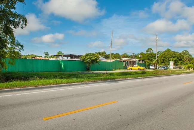
Property Record
4845 45Th St, Vero Beach, FL 32967

NEARBY LISTINGS FOR SALE OR LEASE
-
-
View all Vero Beach listings for sale on LoopNet.com
Property Detail
4845 45Th St
32-39-28-00001-0020-00009.0
Indian River Farms Company S/D
Shipyard
INDIAN RIVER FARMS COMPANY S/D PBS 2-25 SEC 28 TWN 32 RNG 39 TR 2 BEING THE E 5 AC OF THE W 15 AC OF TR 2 LESS THE S 3 AC
X
Indian River
12061C0241H
Florida
2025
2 AC
2025
Fort Pierce/Port St Lucie
050304
Other Market Areas
1,024 SF
Sebastian-Vero Beach, FL
DEMOGRAPHICS near 4845 45Th St
1 Mile
3 Mile
5 Mile
2024 Total Population
5,292
30,496
76,250
2029 Population
5,903
34,296
85,835
Pop Growth 2024-2029
+ 11.55%
+ 12.46%
+ 12.57%
Average Age
43
50
51
2024 Total Households
1,998
13,381
35,424
HH Growth 2024-2029
+ 11.26%
+ 12.17%
+ 12.31%
Median Household Inc
$49,679
$57,993
$59,571
Avg Household Size
2.50
2.20
2.10
2024 Avg HH Vehicles
2.00
2.00
2.00
Median Home Value
$292,221
$315,859
$306,860
Median Year Built
1993
2000
1988
Nearby Places
- Restaurants
- Banks
- Shops
- Fitness
- Groceries
SALE & LEASE HISTORY
LISTING DATE
SALE/LEASE

Sep 24, 2016
For Sale
Nov 24, 2020
For Sale
Jul 10, 2017
For Sale
Nearby Properties
Address
Land Use
TOTAL SIZE
Lot Size
Zoning
Address
Land Use
TOTAL SIZE
Lot Size
Zoning
634,259 SF
53.45 AC
MED
Address
Land Use
TOTAL SIZE
Lot Size
Zoning
571,211 SF
26.38 AC
RM-10
Address
Land Use
TOTAL SIZE
Lot Size
Zoning
21,228 SF
145.79 AC
A-1
Address
Land Use
TOTAL SIZE
Lot Size
Zoning
240,516 SF
39.71 AC
RM-8
Address
Land Use
TOTAL SIZE
Lot Size
Zoning
39,873 SF
7.61 AC
GU
Address
Land Use
TOTAL SIZE
Lot Size
Zoning
2,133 SF
772.04 AC
ALI-A1
Address
Land Use
TOTAL SIZE
Lot Size
Zoning
46,567 SF
19.61 AC
CG
Address
Land Use
TOTAL SIZE
Lot Size
Zoning
204,713 SF
10.56 AC
PDMXD
Address
Land Use
TOTAL SIZE
Lot Size
Zoning
49,513 SF
60.64 AC
ALI-MC
Address
Land Use
TOTAL SIZE
Lot Size
Zoning
408,898 SF
78.81 AC
CG
Address
Land Use
TOTAL SIZE
Lot Size
Zoning
241,529 SF
29.18 AC
RM-8
Address
Land Use
TOTAL SIZE
Lot Size
Zoning
106,904 SF
79.05 AC
M
Address
Land Use
TOTAL SIZE
Lot Size
Zoning
153,530 SF
17.40 AC
CG
Address
Land Use
TOTAL SIZE
Lot Size
Zoning
124.80 AC
Address
Land Use
TOTAL SIZE
Lot Size
Zoning
235,921 SF
28.80 AC
RM-8
Address
Land Use
TOTAL SIZE
Lot Size
Zoning
67,334 SF
9.63 AC
MED
Address
Land Use
TOTAL SIZE
Lot Size
Zoning
351 SF
11.09 AC
CG
Address
Land Use
TOTAL SIZE
Lot Size
Zoning
206,738 SF
17.76 AC
PD
Address
Land Use
TOTAL SIZE
Lot Size
Zoning
69,942 SF
10.47 AC
MED
Address
Land Use
TOTAL SIZE
Lot Size
Zoning
102,808 SF
12.51 AC
CG
Address
Land Use
TOTAL SIZE
Lot Size
Zoning
91,904 SF
10 AC
CG
Address
Land Use
TOTAL SIZE
Lot Size
Zoning
3,540 SF
217.55 AC
ALI-A2
Address
Land Use
TOTAL SIZE
Lot Size
Zoning
132,186 SF
14.66 AC
CG
Address
Land Use
TOTAL SIZE
Lot Size
Zoning
181,621 SF
28.49 AC
RM-6
Address
Land Use
TOTAL SIZE
Lot Size
Zoning
144,137 SF
14.63 AC
PD
Address
Land Use
TOTAL SIZE
Lot Size
Zoning
72,397 SF
10.45 AC
CG
Address
Land Use
TOTAL SIZE
Lot Size
Zoning
221.70 AC
MPZ
Address
Land Use
TOTAL SIZE
Lot Size
Zoning
4,742 SF
38.96 AC
RS-6
Address
Land Use
TOTAL SIZE
Lot Size
Zoning
1,875 SF
8.92 AC
CG
Address
Land Use
TOTAL SIZE
Lot Size
Zoning
94,187 SF
9.15 AC
MED
The World's #1 Commercial Real Estate Marketplace
Connect with us
© 2025 CoStar Group
The information above has been obtained from sources believed reliable. While we do not doubt its accuracy we have not verified it and make no guarantee, warranty or representation about it. It is your responsibility to independently confirm its accuracy and completeness. Any projections, opinions, assumptions, or estimates used are for example only and do not represent the current or future performance of the property. The value of this transaction to you depends on tax and other factors which should be evaluated by your tax, financial, and legal advisors. You and your advisors should conduct a careful, independent investigation of the property to determine to your satisfaction the suitability of the property for your needs.