Property Record
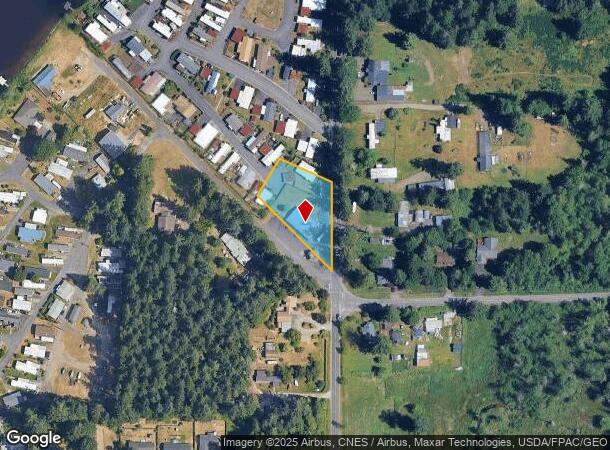
4845 Black Lake Belmore Rd Sw, Olympia, WA 98512
NEARBY LISTINGS FOR SALE OR LEASE
Property Detail
4845 Black Lake Belmore Rd Sw
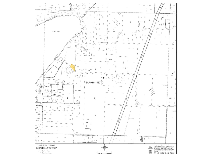
12832230700
32-18-2W PT GOV LOT 2 NWFRAC DAF: BEG INTER WLY MARGIN OF TROSPER RD W/NLY MARGIN DENT RD; N00-12-18W ALG WLY MARGIN 221.24F; N66-41-18W 119.2F; S59-22-45W 115.67F ; S45-04-30E 238.79F POB
Supermarket
Thurston
X
Washington
53067C0164F
2
2024
0.53 AC
2024
Tumwater/S Olympia
011000
Olympia
3,304 SF
Olympia-Tumwater, WA
DEMOGRAPHICS near 4845 Black Lake Belmore Rd Sw
1 Mile
3 Mile
5 Mile
2024 Total Population
1,515
34,542
80,736
2029 Population
1,579
36,550
85,407
Pop Growth 2024-2029
+ 4.22%
+ 5.81%
+ 5.79%
Average Age
47
41
41
2024 Total Households
648
14,906
34,381
HH Growth 2024-2029
+ 4.01%
+ 5.86%
+ 5.92%
Median Household Inc
$95,672
$66,591
$76,049
Avg Household Size
2.30
2.20
2.30
2024 Avg HH Vehicles
2.00
2.00
2.00
Median Home Value
$420,395
$403,064
$423,630
Median Year Built
1980
1991
1986
Nearby Places
Map Layers
Map Styles
 Street
 Aerial
- Restaurants
- Banks
- Shops
- Fitness
- Groceries
Nearby Properties
Address
Land Use
TOTAL SIZE
Lot Size
Zoning
Address
Land Use
TOTAL SIZE
Lot Size
Zoning
523,407 SF
86.49 AC
R-4-8
Address
Land Use
TOTAL SIZE
Lot Size
Zoning
395,355 SF
35.74 AC
TC
Address
Land Use
TOTAL SIZE
Lot Size
Zoning
353,503 SF
36.94 AC
MFM
Address
Land Use
TOTAL SIZE
Lot Size
Zoning
184,887 SF
41 AC
SFM1
Address
Land Use
TOTAL SIZE
Lot Size
Zoning
151,657 SF
2.62 AC
MS
Address
Land Use
TOTAL SIZE
Lot Size
Zoning
235,042 SF
17.16 AC
MFM
Address
Land Use
TOTAL SIZE
Lot Size
Zoning
226,221 SF
Address
Land Use
TOTAL SIZE
Lot Size
Zoning
243,845 SF
12.58 AC
RM-24
Address
Land Use
TOTAL SIZE
Lot Size
Zoning
273,091 SF
17.87 AC
PO/RM
Address
Land Use
TOTAL SIZE
Lot Size
Zoning
163,487 SF
34.49 AC
CS
Address
Land Use
TOTAL SIZE
Lot Size
Zoning
217,366 SF
10.88 AC
RM-24
Address
Land Use
TOTAL SIZE
Lot Size
Zoning
102,698 SF
14.81 AC
LI
Address
Land Use
TOTAL SIZE
Lot Size
Zoning
147,418 SF
11.74 AC
MFH
Address
Land Use
TOTAL SIZE
Lot Size
Zoning
241,689 SF
10.75 AC
RM-24
Address
Land Use
TOTAL SIZE
Lot Size
Zoning
175,938 SF
13 AC
MFM
Address
Land Use
TOTAL SIZE
Lot Size
Zoning
161,002 SF
8.66 AC
PO/RM
Address
Land Use
TOTAL SIZE
Lot Size
Zoning
155,386 SF
6.88 AC
CBC
Address
Land Use
TOTAL SIZE
Lot Size
Zoning
80,956 SF
20.97 AC
SFL
Address
Land Use
TOTAL SIZE
Lot Size
Zoning
140,850 SF
5.73 AC
MFH
Address
Land Use
TOTAL SIZE
Lot Size
Zoning
112,020 SF
5.91 AC
MFH
Address
Land Use
TOTAL SIZE
Lot Size
Zoning
172,092 SF
8.88 AC
RM-24
Address
Land Use
TOTAL SIZE
Lot Size
Zoning
248,879 SF
11.16 AC
LI
Address
Land Use
TOTAL SIZE
Lot Size
Zoning
166,511 SF
8.93 AC
RM-24
Address
Land Use
TOTAL SIZE
Lot Size
Zoning
99,736 SF
6.76 AC
GC
Address
Land Use
TOTAL SIZE
Lot Size
Zoning
76,142 SF
11.94 AC
TC
Address
Land Use
TOTAL SIZE
Lot Size
Zoning
74,740 SF
13.96 AC
LI
Address
Land Use
TOTAL SIZE
Lot Size
Zoning
75,158 SF
19.15 AC
SFM
Address
Land Use
TOTAL SIZE
Lot Size
Zoning
97,399 SF
4.06 AC
MFH
Address
Land Use
TOTAL SIZE
Lot Size
Zoning
97,714 SF
5.18 AC
RM-24
Address
Land Use
TOTAL SIZE
Lot Size
Zoning
139,988 SF
9.50 AC
MFH
The World's #1 Commercial Real Estate Marketplace
Connect with us
© 2025 CoStar Group
The information above has been obtained from sources believed reliable. While we do not doubt its accuracy we have not verified it and make no guarantee, warranty or representation about it. It is your responsibility to independently confirm its accuracy and completeness. Any projections, opinions, assumptions, or estimates used are for example only and do not represent the current or future performance of the property. The value of this transaction to you depends on tax and other factors which should be evaluated by your tax, financial, and legal advisors. You and your advisors should conduct a careful, independent investigation of the property to determine to your satisfaction the suitability of the property for your needs.