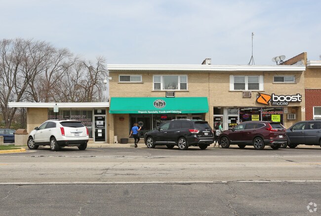
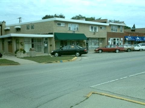
Property Record
4846 Butterfield Rd, Hillside, IL 60162
NEARBY LISTINGS FOR SALE OR LEASE
Property Detail
4846 Butterfield Rd
Chicago-Naperville-Elgin, IL-IN-WI
Vendley & Companys Add 04
15-07-416-033-0000
LOT 24 IN BLK 2 IN VENDLEY & COMPAN YS 4TH ADD TO HILLSIDE S2 E2 SE4 S E4 OF SEC07+ T39N R12E 3P
Miscresidentialimprovement
Cook
X
Illinois
17031C0369J
24
2023
0.07 AC
2024
Melrose Park Area
818300
Chicago
3,216 SF
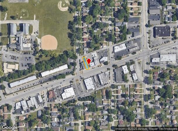
DEMOGRAPHICS near 4846 Butterfield Rd
1 Mile
3 Mile
5 Mile
2024 Total Population
14,326
128,401
329,610
2029 Population
13,904
125,004
321,989
Pop Growth 2024-2029
(2.95%)
(2.65%)
(2.31%)
Average Age
41
41
41
2024 Total Households
4,792
44,895
118,674
HH Growth 2024-2029
(3.23%)
(2.84%)
(2.48%)
Median Household Inc
$72,323
$81,220
$83,355
Avg Household Size
2.90
2.70
2.70
2024 Avg HH Vehicles
2.00
2.00
2.00
Median Home Value
$209,564
$274,534
$291,769
Median Year Built
1957
1957
1957
Nearby Places
Map Layers
Map Styles
 Street
 Aerial
- Restaurants
- Banks
- Shops
- Fitness
- Groceries
PUBLIC TRANSPORTATION
COMMUTER RAIL
Bellwood Station (Union Pacific West Line - Northeast Illinois Regional Commuter Railroad (Metra))
DRIVE
WALK
Distance
Bellwood Station (Union Pacific West Line - Northeast Illinois Regional Commuter Railroad (Metra))
5 min
1.9 mi
Berkeley Station (Union Pacific West Line - Northeast Illinois Regional Commuter Railroad (Metra))
DRIVE
WALK
Distance
Berkeley Station (Union Pacific West Line - Northeast Illinois Regional Commuter Railroad (Metra))
5 min
2.0 mi
AIRPORT
Chicago O'Hare International
DRIVE
WALK
Distance
Chicago O'Hare International
36 min
12.1 mi
Chicago Midway International
DRIVE
WALK
Distance
Chicago Midway International
28 min
14.0 mi
Nearby Properties
Address
Land Use
TOTAL SIZE
Lot Size
Zoning
Address
Land Use
TOTAL SIZE
Lot Size
Zoning
345,161 SF
23.37 AC
C
Address
Land Use
TOTAL SIZE
Lot Size
Zoning
1,089,750 SF
59.83 AC
I
Address
Land Use
TOTAL SIZE
Lot Size
Zoning
Address
Land Use
TOTAL SIZE
Lot Size
Zoning
347,240 SF
1.18 AC
Address
Land Use
TOTAL SIZE
Lot Size
Zoning
435,740 SF
17.74 AC
C
Address
Land Use
TOTAL SIZE
Lot Size
Zoning
86.63 AC
Address
Land Use
TOTAL SIZE
Lot Size
Zoning
309,570 SF
1.02 AC
Address
Land Use
TOTAL SIZE
Lot Size
Zoning
15.17 AC
Address
Land Use
TOTAL SIZE
Lot Size
Zoning
740,508 SF
9.82 AC
C
Address
Land Use
TOTAL SIZE
Lot Size
Zoning
224,145 SF
2.48 AC
Address
Land Use
TOTAL SIZE
Lot Size
Zoning
240,073 SF
1.04 AC
Address
Land Use
TOTAL SIZE
Lot Size
Zoning
221,673 SF
4.49 AC
Address
Land Use
TOTAL SIZE
Lot Size
Zoning
973,922 SF
53.84 AC
I
Address
Land Use
TOTAL SIZE
Lot Size
Zoning
518,123 SF
18.20 AC
C
Address
Land Use
TOTAL SIZE
Lot Size
Zoning
204,600 SF
9.45 AC
M
Address
Land Use
TOTAL SIZE
Lot Size
Zoning
969,696 SF
44.30 AC
Address
Land Use
TOTAL SIZE
Lot Size
Zoning
251,223 SF
5.71 AC
C
Address
Land Use
TOTAL SIZE
Lot Size
Zoning
0.84 AC
Address
Land Use
TOTAL SIZE
Lot Size
Zoning
152,332 SF
3.60 AC
Address
Land Use
TOTAL SIZE
Lot Size
Zoning
221,111 SF
20.62 AC
Address
Land Use
TOTAL SIZE
Lot Size
Zoning
105,443 SF
5.15 AC
C
Address
Land Use
TOTAL SIZE
Lot Size
Zoning
516,605 SF
16.29 AC
Address
Land Use
TOTAL SIZE
Lot Size
Zoning
98,990 SF
3.52 AC
C
Address
Land Use
TOTAL SIZE
Lot Size
Zoning
78,264 SF
1.03 AC
Address
Land Use
TOTAL SIZE
Lot Size
Zoning
250,892 SF
9.04 AC
C
Address
Land Use
TOTAL SIZE
Lot Size
Zoning
6.26 AC
Address
Land Use
TOTAL SIZE
Lot Size
Zoning
218,192 SF
10.32 AC
C
Address
Land Use
TOTAL SIZE
Lot Size
Zoning
190,719 SF
10.10 AC
Address
Land Use
TOTAL SIZE
Lot Size
Zoning
250,870 SF
19.23 AC
Address
Land Use
TOTAL SIZE
Lot Size
Zoning
128,536 SF
17.06 AC
C
The World's #1 Commercial Real Estate Marketplace
Connect with us
© 2025 CoStar Group
The information above has been obtained from sources believed reliable. While we do not doubt its accuracy we have not verified it and make no guarantee, warranty or representation about it. It is your responsibility to independently confirm its accuracy and completeness. Any projections, opinions, assumptions, or estimates used are for example only and do not represent the current or future performance of the property. The value of this transaction to you depends on tax and other factors which should be evaluated by your tax, financial, and legal advisors. You and your advisors should conduct a careful, independent investigation of the property to determine to your satisfaction the suitability of the property for your needs.