Property Record
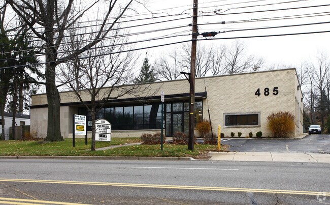
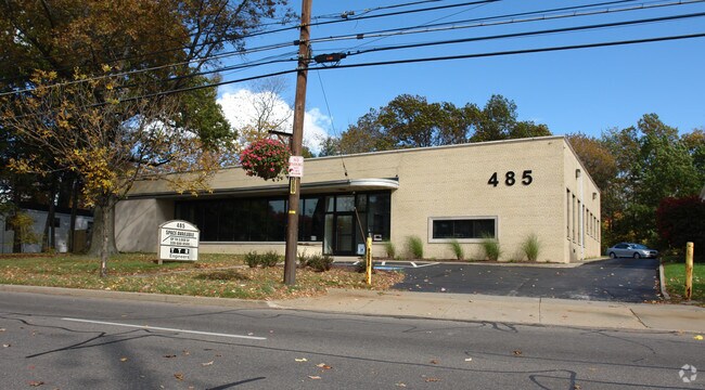
485 Canton Rd, Akron, OH 44312

Property Detail
485 Canton Rd
Akron, OH
TR 6 LOT 2 E OF RD N OF TERR ANNEX AUD#11709
67-02014
Summit
Retirementnursinghomecombined
Ohio
2023
2
2025
0.62 AC
503702
Akron
4,872 SF
Cleveland
NEARBY LISTINGS FOR SALE OR LEASE
DEMOGRAPHICS near 485 Canton Rd
1 mile
3 mile
5 mile
2025 Total Population
11,984
61,615
139,723
2030 Population
11,963
61,676
140,182
Pop Growth 2025-2030
(0.18%)
+ 0.10%
+ 0.33%
Average Age
43
41
40
2025 Total Households
5,538
26,694
58,703
HH Growth 2025-2030
(0.27%)
+ 0.05%
+ 0.31%
Median Household Inc
$64,092
$57,241
$54,206
Avg Household Size
2.10
2.30
2.30
2025 Avg HH Vehicles
2.00
2.00
2.00
Median Home Value
$146,277
$143,281
$149,784
Median Year Built
1958
1958
1958
Nearby Places
Map Layers
Map Styles
 Street
 Aerial
Transit
 Traffic
 Biking
Places
Listings with unknown addresses are not visible on the map
- Restaurants
- Banks
- Shops
- Fitness
- Groceries
PUBLIC TRANSPORTATION
COMMUTER RAIL
Drive
Walk
Distance
12 min
6.3 mi
Drive
Walk
Distance
21 min
9.6 mi
AIRPORT
Akron-Canton Regional
Drive
Walk
Distance
Akron-Canton Regional
22 min
11.5 mi
Cleveland-Hopkins International
Drive
Walk
Distance
Cleveland-Hopkins International
64 min
45.4 mi
Nearby Properties
Address
Land Use
TOTAL SIZE
Lot Size
Zoning
Address
Land Use
TOTAL SIZE
Lot Size
Zoning
Address
Land Use
TOTAL SIZE
Lot Size
Zoning
162,774 SF
16.58 AC
Address
Land Use
TOTAL SIZE
Lot Size
Zoning
264,753 SF
22.87 AC
Address
Land Use
TOTAL SIZE
Lot Size
Zoning
Address
Land Use
TOTAL SIZE
Lot Size
Zoning
Address
Land Use
TOTAL SIZE
Lot Size
Zoning
245,911 SF
14.48 AC
Address
Land Use
TOTAL SIZE
Lot Size
Zoning
142,848 SF
13.85 AC
Address
Land Use
TOTAL SIZE
Lot Size
Zoning
639,478 SF
29.51 AC
Address
Land Use
TOTAL SIZE
Lot Size
Zoning
95,696 SF
8.29 AC
Address
Land Use
TOTAL SIZE
Lot Size
Zoning
Address
Land Use
TOTAL SIZE
Lot Size
Zoning
270,860 SF
131.89 AC
Address
Land Use
TOTAL SIZE
Lot Size
Zoning
115,586 SF
4.93 AC
Address
Land Use
TOTAL SIZE
Lot Size
Zoning
374,370 SF
27.79 AC
Address
Land Use
TOTAL SIZE
Lot Size
Zoning
56,529 SF
3.67 AC
Address
Land Use
TOTAL SIZE
Lot Size
Zoning
203,059 SF
55.62 AC
Address
Land Use
TOTAL SIZE
Lot Size
Zoning
72,162 SF
4.76 AC
Address
Land Use
TOTAL SIZE
Lot Size
Zoning
6.06 AC
Address
Land Use
TOTAL SIZE
Lot Size
Zoning
489,909 SF
23.77 AC
Address
Land Use
TOTAL SIZE
Lot Size
Zoning
5,863 SF
343.43 AC
Address
Land Use
TOTAL SIZE
Lot Size
Zoning
882,093 SF
50.96 AC
Address
Land Use
TOTAL SIZE
Lot Size
Zoning
68,979 SF
5.07 AC
Address
Land Use
TOTAL SIZE
Lot Size
Zoning
65,350 SF
9.99 AC
Address
Land Use
TOTAL SIZE
Lot Size
Zoning
124,939 SF
13.89 AC
Address
Land Use
TOTAL SIZE
Lot Size
Zoning
667,050 SF
24.55 AC
Address
Land Use
TOTAL SIZE
Lot Size
Zoning
60,943 SF
2.26 AC
Address
Land Use
TOTAL SIZE
Lot Size
Zoning
55,072 SF
3.41 AC
Address
Land Use
TOTAL SIZE
Lot Size
Zoning
58,910 SF
3.15 AC
Address
Land Use
TOTAL SIZE
Lot Size
Zoning
97,454 SF
3.14 AC
Address
Land Use
TOTAL SIZE
Lot Size
Zoning
235,498 SF
21.41 AC
Address
Land Use
TOTAL SIZE
Lot Size
Zoning
141,342 SF
6.34 AC
The World's #1 Commercial Real Estate Marketplace
Connect with us
© 2026 CoStar Group
The information above has been obtained from sources believed reliable. While we do not doubt its accuracy we have not verified it and make no guarantee, warranty or representation about it. It is your responsibility to independently confirm its accuracy and completeness. Any projections, opinions, assumptions, or estimates used are for example only and do not represent the current or future performance of the property. The value of this transaction to you depends on tax and other factors which should be evaluated by your tax, financial, and legal advisors. You and your advisors should conduct a careful, independent investigation of the property to determine to your satisfaction the suitability of the property for your needs.