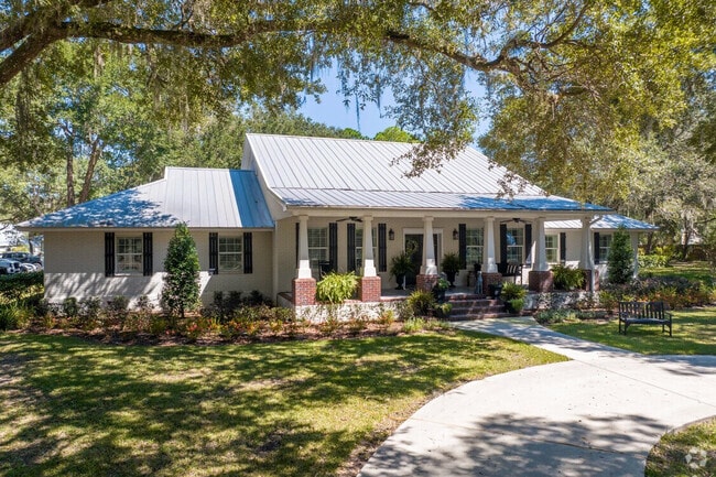
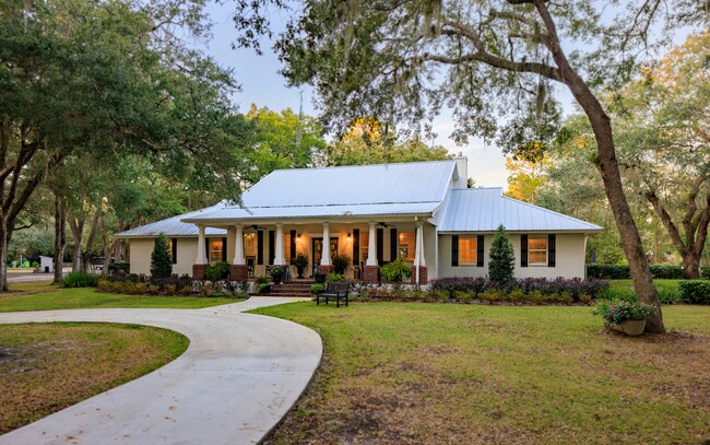
Property Record
485 Chandler Oaks Ln, Saint Augustine, FL 32092

Save to a Folder
{{folder.Name}}
{{folder.ListingIds.length}} Properties
{{folder.ListingIds.length}} Property
Create a New Folder
Property Detail
485 Chandler Oaks Ln
013630-0040
1-4 PTS GLS 2 3 & 5 PT OF WLY 800FT LYING E OF SEC 41 & SLY 60FT STRIP BEING PT OF GLS 3 & 4 S OF SEC 41 - 60FT ON RD 13 (EX PT IN OR1299/1498) OR3821/189
Commercialnec
Saint Johns
OR
Florida
AE The base floodplain where base flood elevations are provided. AE Zones are now used on new format FIRMs instead of A1-A30 Zones.
1
2025
20.47 AC
2026
St Johns County
021004
Jacksonville (Florida)
13,637 SF
Jacksonville, FL
NEARBY LISTINGS FOR SALE OR LEASE
-
-
View all Saint Augustine listings for sale on LoopNet.com
DEMOGRAPHICS near 485 Chandler Oaks Ln
1 mile
3 mile
5 mile
2025 Total Population
364
7,389
24,867
2030 Population
420
8,570
28,968
Pop Growth 2025-2030
+ 15.38%
+ 15.98%
+ 16.49%
Average Age
47
41
41
2025 Total Households
150
2,543
8,521
HH Growth 2025-2030
+ 16.00%
+ 16.36%
+ 17.11%
Median Household Inc
$113,690
$121,197
$111,820
Avg Household Size
2.40
2.80
2.80
2025 Avg HH Vehicles
2.00
2.00
2.00
Median Home Value
$691,176
$589,460
$574,197
Median Year Built
1995
2003
2008
Nearby Places
Map Layers
Map Styles
 Street
 Aerial
Layers
 Traffic
 Biking
Places
Listings with unknown addresses are not visible on the map
- Restaurants
- Banks
- Shops
- Fitness
- Groceries
SALE & LEASE HISTORY
LISTING DATE
SALE/LEASE

Sep 27, 2022
For Sale
Nearby Properties
Address
Land Use
TOTAL SIZE
Lot Size
Zoning
Address
Land Use
TOTAL SIZE
Lot Size
Zoning
5,564 SF
91.85 AC
Address
Land Use
TOTAL SIZE
Lot Size
Zoning
10,107 SF
1.35 AC
RS2
Address
Land Use
TOTAL SIZE
Lot Size
Zoning
1,728 SF
21.46 AC
RMH
Address
Land Use
TOTAL SIZE
Lot Size
Zoning
4,128 SF
100 AC
OR
Address
Land Use
TOTAL SIZE
Lot Size
Zoning
2,655 SF
109.43 AC
OR
Address
Land Use
TOTAL SIZE
Lot Size
Zoning
5,248 SF
1.40 AC
RS2
Address
Land Use
TOTAL SIZE
Lot Size
Zoning
6,418 SF
5.11 AC
OR
Address
Land Use
TOTAL SIZE
Lot Size
Zoning
5,065 SF
66.79 AC
OR
Address
Land Use
TOTAL SIZE
Lot Size
Zoning
9,931 SF
46.99 AC
Address
Land Use
TOTAL SIZE
Lot Size
Zoning
3,670 SF
87.15 AC
PRD
Address
Land Use
TOTAL SIZE
Lot Size
Zoning
Address
Land Use
TOTAL SIZE
Lot Size
Zoning
4,312 SF
14.30 AC
OR
Address
Land Use
TOTAL SIZE
Lot Size
Zoning
2,360 SF
2.11 AC
RS2
Address
Land Use
TOTAL SIZE
Lot Size
Zoning
12,739 SF
2.60 AC
OR
Address
Land Use
TOTAL SIZE
Lot Size
Zoning
8,988 SF
18.90 AC
OR
Address
Land Use
TOTAL SIZE
Lot Size
Zoning
10,234 SF
72.30 AC
OR
Address
Land Use
TOTAL SIZE
Lot Size
Zoning
Address
Land Use
TOTAL SIZE
Lot Size
Zoning
5,653 SF
81.21 AC
OR
Address
Land Use
TOTAL SIZE
Lot Size
Zoning
4,136 SF
3.98 AC
OR
Address
Land Use
TOTAL SIZE
Lot Size
Zoning
3,194 SF
0.78 AC
OR
Address
Land Use
TOTAL SIZE
Lot Size
Zoning
4,445 SF
6.98 AC
Address
Land Use
TOTAL SIZE
Lot Size
Zoning
4,261 SF
11.50 AC
OR
Address
Land Use
TOTAL SIZE
Lot Size
Zoning
6,575 SF
4.18 AC
CI
Address
Land Use
TOTAL SIZE
Lot Size
Zoning
9,577 SF
50 AC
OR
Address
Land Use
TOTAL SIZE
Lot Size
Zoning
3,220 SF
7.85 AC
Address
Land Use
TOTAL SIZE
Lot Size
Zoning
4,104 SF
1.55 AC
RS2
Address
Land Use
TOTAL SIZE
Lot Size
Zoning
Address
Land Use
TOTAL SIZE
Lot Size
Zoning
4,790 SF
1.62 AC
RS2
Address
Land Use
TOTAL SIZE
Lot Size
Zoning
2,830 SF
14.61 AC
OR
The World's #1 Commercial Real Estate Marketplace
Connect with us
© 2026 CoStar Group
The information above has been obtained from sources believed reliable. While we do not doubt its accuracy we have not verified it and make no guarantee, warranty or representation about it. It is your responsibility to independently confirm its accuracy and completeness. Any projections, opinions, assumptions, or estimates used are for example only and do not represent the current or future performance of the property. The value of this transaction to you depends on tax and other factors which should be evaluated by your tax, financial, and legal advisors. You and your advisors should conduct a careful, independent investigation of the property to determine to your satisfaction the suitability of the property for your needs.