Property Record
485 E Santa Ana Ave, Bloomington, CA 92316


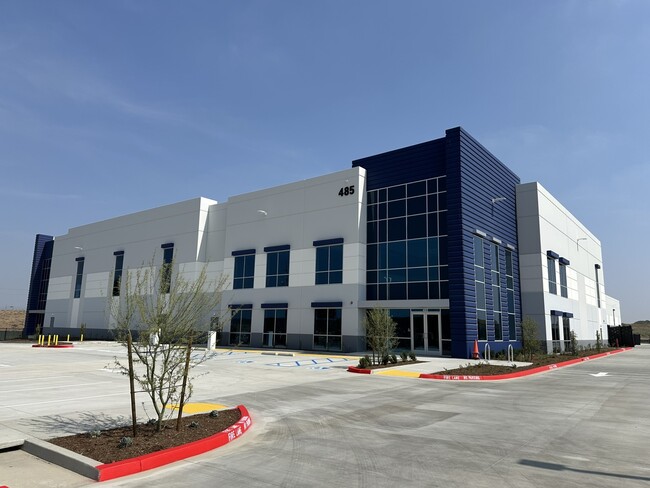

This Property Is For Sale
Current Lease Availabilities
NEARBY LISTINGS FOR SALE OR LEASE
Property Detail
485 E Santa Ana Ave
0258-141-17
PORTION PARCEL MAP NO. 11516 PARCEL 1 BEGINNING AT A POINT IN THE NORTH LINE OF PARCEL MAP NO. 11516 AND THE SOUTH LINE OF SANTA ANA AVENUE (32 FOOT HALF WIDTH) DISTANT EASTERLY THEREON 725.26 FEET FROM THE NORTHWEST CORNER OF PARCEL 1 OF PARCEL MAP
Warehouse
San Bernardino
X
California
06065C0065H
4.10 AC
2025
San Bernardino
2025
Inland Empire (California)
004001
Riverside-San Bernardino-Ontario, CA
81,494 SF
DEMOGRAPHICS near 485 E Santa Ana Ave
1 mile
3 mile
5 mile
2024 Total Population
202
90,387
315,136
2029 Population
204
91,983
322,212
Pop Growth 2024-2029
+ 0.99%
+ 1.77%
+ 2.25%
Average Age
36
35
35
2024 Total Households
46
24,215
86,347
HH Growth 2024-2029
0.00%
+ 1.80%
+ 2.27%
Median Household Inc
$80,000
$67,447
$68,583
Avg Household Size
4.10
3.60
3.50
2024 Avg HH Vehicles
3.00
2.00
2.00
Median Home Value
$602,273
$372,839
$379,771
Median Year Built
1973
1977
1975
Nearby Places
Map Layers
Map Styles
 Street
 Aerial
Transit
 Traffic
 Biking
Places
Listings with unknown addresses are not visible on the map
- Restaurants
- Banks
- Shops
- Fitness
- Groceries
PUBLIC TRANSPORTATION
COMMUTER RAIL
Rialto (San Bernardino Line - Southern California Regional Rail Authority (Metrolink))
Drive
Walk
Distance
Rialto (San Bernardino Line - Southern California Regional Rail Authority (Metrolink))
7 min
3.7 mi
Riverside-Hunter Park/Ucr (Metrolink 91-Perris Valley Line - Metrolink Trains)
Drive
Walk
Distance
Riverside-Hunter Park/Ucr (Metrolink 91-Perris Valley Line - Metrolink Trains)
10 min
5.9 mi
AIRPORT
Ontario International
Drive
Walk
Distance
Ontario International
22 min
15.4 mi
Freight Ports
Port of Long Beach
Drive
Walk
Distance
Port of Long Beach
82 min
62.5 mi
Nearby Properties
Address
Land Use
TOTAL SIZE
Lot Size
Zoning
Address
Land Use
TOTAL SIZE
Lot Size
Zoning
1,186,950 SF
54.77 AC
Address
Land Use
TOTAL SIZE
Lot Size
Zoning
1,025,132 SF
46.44 AC
Address
Land Use
TOTAL SIZE
Lot Size
Zoning
1,264,064 SF
64.44 AC
Address
Land Use
TOTAL SIZE
Lot Size
Zoning
1,000,177 SF
46 AC
Address
Land Use
TOTAL SIZE
Lot Size
Zoning
798,304 SF
42.64 AC
AMSP
Address
Land Use
TOTAL SIZE
Lot Size
Zoning
505,152 SF
28.88 AC
Address
Land Use
TOTAL SIZE
Lot Size
Zoning
677,280 SF
34.53 AC
BLRS1AA
Address
Land Use
TOTAL SIZE
Lot Size
Zoning
615,310 SF
49.91 AC
Address
Land Use
TOTAL SIZE
Lot Size
Zoning
344,360 SF
17.32 AC
Address
Land Use
TOTAL SIZE
Lot Size
Zoning
599,735 SF
33.25 AC
AMSP
Address
Land Use
TOTAL SIZE
Lot Size
Zoning
311,363 SF
34.60 AC
BLRS20M
Address
Land Use
TOTAL SIZE
Lot Size
Zoning
411,707 SF
19.34 AC
Address
Land Use
TOTAL SIZE
Lot Size
Zoning
401,106 SF
16.91 AC
Address
Land Use
TOTAL SIZE
Lot Size
Zoning
340,120 SF
36.36 AC
Address
Land Use
TOTAL SIZE
Lot Size
Zoning
272,120 SF
13.05 AC
Address
Land Use
TOTAL SIZE
Lot Size
Zoning
525,110 SF
24.25 AC
Address
Land Use
TOTAL SIZE
Lot Size
Zoning
492,631 SF
21 AC
Address
Land Use
TOTAL SIZE
Lot Size
Zoning
35,260 SF
9.55 AC
Address
Land Use
TOTAL SIZE
Lot Size
Zoning
447,190 SF
21.08 AC
Address
Land Use
TOTAL SIZE
Lot Size
Zoning
182,624 SF
16.07 AC
Address
Land Use
TOTAL SIZE
Lot Size
Zoning
245,476 SF
15.61 AC
Address
Land Use
TOTAL SIZE
Lot Size
Zoning
424,904 SF
23.03 AC
Address
Land Use
TOTAL SIZE
Lot Size
Zoning
261,632 SF
13.16 AC
Address
Land Use
TOTAL SIZE
Lot Size
Zoning
610,400 SF
27.41 AC
BLIR
Address
Land Use
TOTAL SIZE
Lot Size
Zoning
208,510 SF
47.30 AC
BLIC
Address
Land Use
TOTAL SIZE
Lot Size
Zoning
1,056,072 SF
51.85 AC
AMSP
Address
Land Use
TOTAL SIZE
Lot Size
Zoning
55.22 AC
AMSP
Address
Land Use
TOTAL SIZE
Lot Size
Zoning
72,860 SF
7.71 AC
Address
Land Use
TOTAL SIZE
Lot Size
Zoning
750,700 SF
32.81 AC
AMSP
Address
Land Use
TOTAL SIZE
Lot Size
Zoning
47,809 SF
11.73 AC
The World's #1 Commercial Real Estate Marketplace
Connect with us
© 2026 CoStar Group
The information above has been obtained from sources believed reliable. While we do not doubt its accuracy we have not verified it and make no guarantee, warranty or representation about it. It is your responsibility to independently confirm its accuracy and completeness. Any projections, opinions, assumptions, or estimates used are for example only and do not represent the current or future performance of the property. The value of this transaction to you depends on tax and other factors which should be evaluated by your tax, financial, and legal advisors. You and your advisors should conduct a careful, independent investigation of the property to determine to your satisfaction the suitability of the property for your needs.