Property Record
485 Glen Rd, Sparta, NJ 07871

Save to a Folder
{{folder.Name}}
{{folder.ListingIds.length}} Properties
{{folder.ListingIds.length}} Property
Create a New Folder
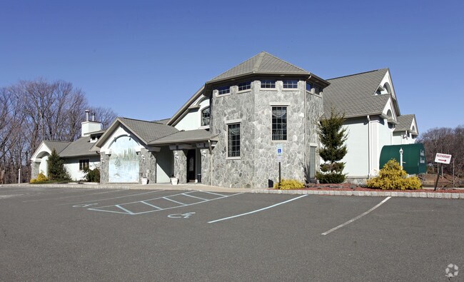
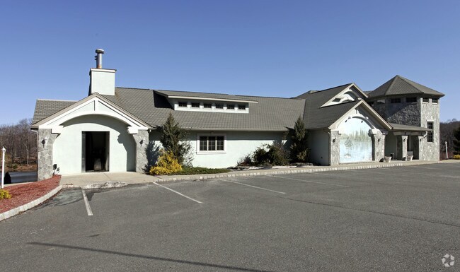
Property Detail
485 Glen Rd
18-29001-0000-00095
Sussex
Restaurantbuilding
New Jersey
RR
95
B and X Area of moderate flood hazard, usually the area between the limits of the 100-year and 500-year floods.
2.83 AC
2025
Sussex County
2026
Northern New Jersey
373200
Newark, NJ
12,462 SF
NEARBY LISTINGS FOR SALE OR LEASE
DEMOGRAPHICS near 485 Glen Rd
1 mile
3 mile
5 mile
2025 Total Population
1,132
9,512
37,213
2030 Population
1,154
9,685
38,166
Pop Growth 2025-2030
+ 1.94%
+ 1.82%
+ 2.56%
Average Age
40
41
43
2025 Total Households
379
3,344
13,956
HH Growth 2025-2030
+ 1.85%
+ 1.82%
+ 2.63%
Median Household Inc
$196,938
$154,738
$132,214
Avg Household Size
3.00
2.80
2.60
2025 Avg HH Vehicles
3.00
2.00
2.00
Median Home Value
$606,164
$475,806
$441,359
Median Year Built
1982
1979
1972
Nearby Places
Map Layers
Map Styles
 Street
 Aerial
Layers
 Traffic
 Biking
Places
Listings with unknown addresses are not visible on the map
- Restaurants
- Banks
- Shops
- Fitness
- Groceries
PUBLIC TRANSPORTATION
AIRPORT
Newark Liberty International
Drive
Walk
Distance
Newark Liberty International
64 min
44.2 mi
Freight Ports
Maher Terminal
Drive
Walk
Distance
Maher Terminal
68 min
44.8 mi
Nearby Properties
Address
Land Use
TOTAL SIZE
Lot Size
Zoning
Address
Land Use
TOTAL SIZE
Lot Size
Zoning
134,375 SF
27.71 AC
OSGU
Address
Land Use
TOTAL SIZE
Lot Size
Zoning
97 AC
RC
Address
Land Use
TOTAL SIZE
Lot Size
Zoning
132,501 SF
91.14 AC
OSGU
Address
Land Use
TOTAL SIZE
Lot Size
Zoning
11.86 AC
TCLC
Address
Land Use
TOTAL SIZE
Lot Size
Zoning
1,620 SF
787.07 AC
RC
Address
Land Use
TOTAL SIZE
Lot Size
Zoning
1,244.66 AC
RC
Address
Land Use
TOTAL SIZE
Lot Size
Zoning
34,715 SF
3 AC
TCC
Address
Land Use
TOTAL SIZE
Lot Size
Zoning
47,786 SF
8.60 AC
TCCO
Address
Land Use
TOTAL SIZE
Lot Size
Zoning
676.50 AC
OSGU
Address
Land Use
TOTAL SIZE
Lot Size
Zoning
5,954 SF
5.07 AC
TCC
Address
Land Use
TOTAL SIZE
Lot Size
Zoning
51,438 SF
25.30 AC
PC
Address
Land Use
TOTAL SIZE
Lot Size
Zoning
5,190 SF
5 AC
RC
Address
Land Use
TOTAL SIZE
Lot Size
Zoning
18,048 SF
1.50 AC
TCC
Address
Land Use
TOTAL SIZE
Lot Size
Zoning
37,638 SF
2.20 AC
TCMS
Address
Land Use
TOTAL SIZE
Lot Size
Zoning
5.59 AC
TCLC
Address
Land Use
TOTAL SIZE
Lot Size
Zoning
9.43 AC
R100
Address
Land Use
TOTAL SIZE
Lot Size
Zoning
13,220 SF
0.97 AC
RR
Address
Land Use
TOTAL SIZE
Lot Size
Zoning
44,554 SF
6.12 AC
C1
Address
Land Use
TOTAL SIZE
Lot Size
Zoning
36,667 SF
1.75 AC
TCC
Address
Land Use
TOTAL SIZE
Lot Size
Zoning
234.45 AC
MD10
Address
Land Use
TOTAL SIZE
Lot Size
Zoning
4,160 SF
96.54 AC
OSGU
Address
Land Use
TOTAL SIZE
Lot Size
Zoning
24,532 SF
5.24 AC
RR
Address
Land Use
TOTAL SIZE
Lot Size
Zoning
372.04 AC
OSGU
Address
Land Use
TOTAL SIZE
Lot Size
Zoning
396.43 AC
OSGU
Address
Land Use
TOTAL SIZE
Lot Size
Zoning
7.57 AC
MF-3
Address
Land Use
TOTAL SIZE
Lot Size
Zoning
213.33 AC
MD10
Address
Land Use
TOTAL SIZE
Lot Size
Zoning
32.60 AC
RR
Address
Land Use
TOTAL SIZE
Lot Size
Zoning
370.14 AC
RC
Address
Land Use
TOTAL SIZE
Lot Size
Zoning
3,798 SF
26.96 AC
ED
Address
Land Use
TOTAL SIZE
Lot Size
Zoning
345 AC
RC
The World's #1 Commercial Real Estate Marketplace
Connect with us
© 2026 CoStar Group
The information above has been obtained from sources believed reliable. While we do not doubt its accuracy we have not verified it and make no guarantee, warranty or representation about it. It is your responsibility to independently confirm its accuracy and completeness. Any projections, opinions, assumptions, or estimates used are for example only and do not represent the current or future performance of the property. The value of this transaction to you depends on tax and other factors which should be evaluated by your tax, financial, and legal advisors. You and your advisors should conduct a careful, independent investigation of the property to determine to your satisfaction the suitability of the property for your needs.