Property Record
485 Jimmy Deloach Pkwy, Port Wentworth, GA 31407

NEARBY LISTINGS FOR SALE OR LEASE
Property Detail
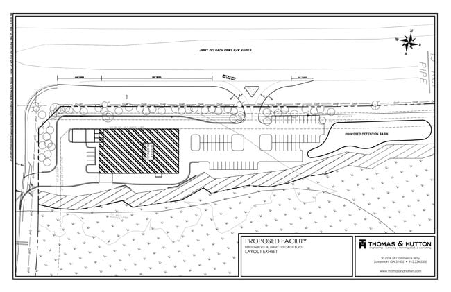
485 Jimmy Deloach Pkwy
Savannah, GA
Tract Sub
2101601042
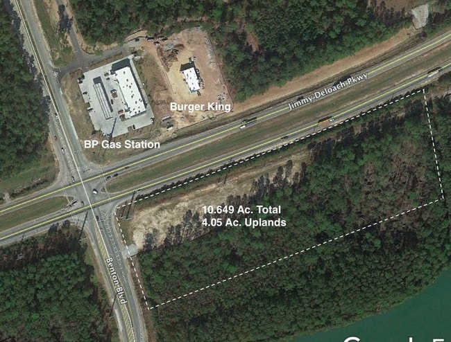
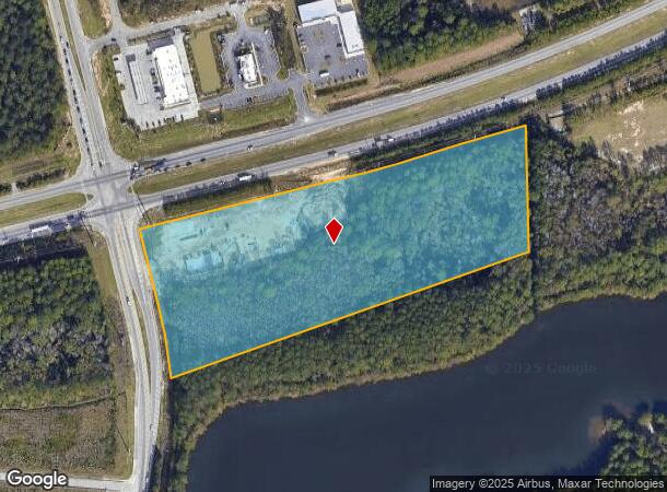
LOT 5 GODLEY TRACT SUB BK 50 P G 616 10.649AC
Supermarket
Chatham
AE
Georgia
45053C0475D
5
2024
10.65 AC
2025
N Savannah/Garden City
010704
Savannah
5,696 SF
DEMOGRAPHICS near 485 Jimmy Deloach Pkwy
1 Mile
3 Mile
5 Mile
2024 Total Population
3,611
28,633
49,334
2029 Population
3,843
30,395
52,815
Pop Growth 2024-2029
+ 6.42%
+ 6.15%
+ 7.06%
Average Age
33
35
36
2024 Total Households
1,408
10,636
18,377
HH Growth 2024-2029
+ 6.32%
+ 6.19%
+ 7.01%
Median Household Inc
$86,073
$91,074
$80,971
Avg Household Size
2.50
2.50
2.60
2024 Avg HH Vehicles
2.00
2.00
2.00
Median Home Value
$237,121
$238,500
$222,629
Median Year Built
2011
2010
2007
Nearby Places
- Restaurants
- Banks
- Shops
- Fitness
- Groceries
PUBLIC TRANSPORTATION
AIRPORT
Savannah/Hilton Head International
DRIVE
WALK
Distance
Savannah/Hilton Head International
19 min
6.6 mi
Freight Ports
Georgia Ports - Savannah
DRIVE
WALK
Distance
Georgia Ports - Savannah
14 min
7.5 mi
SALE & LEASE HISTORY
LISTING DATE
SALE/LEASE

Apr 24, 2017
For Sale
Nearby Properties
Address
Land Use
TOTAL SIZE
Lot Size
Zoning
Address
Land Use
TOTAL SIZE
Lot Size
Zoning
1,400,224 SF
325.62 AC
I-H
Address
Land Use
TOTAL SIZE
Lot Size
Zoning
426,547 SF
15.29 AC
Address
Land Use
TOTAL SIZE
Lot Size
Zoning
432,965 SF
10.09 AC
Address
Land Use
TOTAL SIZE
Lot Size
Zoning
605,200 SF
59.62 AC
I-H
Address
Land Use
TOTAL SIZE
Lot Size
Zoning
1,003,267 SF
64.07 AC
I-H
Address
Land Use
TOTAL SIZE
Lot Size
Zoning
42,338 SF
65.96 AC
PUD
Address
Land Use
TOTAL SIZE
Lot Size
Zoning
1,584 SF
67.35 AC
I1
Address
Land Use
TOTAL SIZE
Lot Size
Zoning
800,100 SF
44.51 AC
I-H
Address
Land Use
TOTAL SIZE
Lot Size
Zoning
754,000 SF
63.38 AC
I-H
Address
Land Use
TOTAL SIZE
Lot Size
Zoning
737,500 SF
49.38 AC
I-1
Address
Land Use
TOTAL SIZE
Lot Size
Zoning
728,500 SF
67.67 AC
Address
Land Use
TOTAL SIZE
Lot Size
Zoning
70,000 SF
71.90 AC
IH
Address
Land Use
TOTAL SIZE
Lot Size
Zoning
998,400 SF
123.21 AC
Address
Land Use
TOTAL SIZE
Lot Size
Zoning
70.39 AC
Address
Land Use
TOTAL SIZE
Lot Size
Zoning
24,648 SF
23.38 AC
Address
Land Use
TOTAL SIZE
Lot Size
Zoning
27,420 SF
34.55 AC
R1
Address
Land Use
TOTAL SIZE
Lot Size
Zoning
631,800 SF
38.47 AC
Address
Land Use
TOTAL SIZE
Lot Size
Zoning
103,840 SF
49.10 AC
I-L
Address
Land Use
TOTAL SIZE
Lot Size
Zoning
2,000 SF
24.74 AC
PUDCC
Address
Land Use
TOTAL SIZE
Lot Size
Zoning
9,505 SF
0.07 AC
Address
Land Use
TOTAL SIZE
Lot Size
Zoning
285,905 SF
20.16 AC
I-L
Address
Land Use
TOTAL SIZE
Lot Size
Zoning
109,284 SF
24.54 AC
R-3-B
Address
Land Use
TOTAL SIZE
Lot Size
Zoning
4,888 SF
37.80 AC
PUDC
Address
Land Use
TOTAL SIZE
Lot Size
Zoning
25,656 SF
23.69 AC
PUDC
Address
Land Use
TOTAL SIZE
Lot Size
Zoning
2,156 SF
36.64 AC
PIL
Address
Land Use
TOTAL SIZE
Lot Size
Zoning
10,600 SF
21.93 AC
PUD
Address
Land Use
TOTAL SIZE
Lot Size
Zoning
23,946 SF
22.68 AC
PUDC
Address
Land Use
TOTAL SIZE
Lot Size
Zoning
3,648 SF
66.30 AC
I-L
Address
Land Use
TOTAL SIZE
Lot Size
Zoning
22,220 SF
27.20 AC
PUDC
Address
Land Use
TOTAL SIZE
Lot Size
Zoning
499,200 SF
33.02 AC
PUDC
The World's #1 Commercial Real Estate Marketplace
Connect with us
© 2025 CoStar Group
The information above has been obtained from sources believed reliable. While we do not doubt its accuracy we have not verified it and make no guarantee, warranty or representation about it. It is your responsibility to independently confirm its accuracy and completeness. Any projections, opinions, assumptions, or estimates used are for example only and do not represent the current or future performance of the property. The value of this transaction to you depends on tax and other factors which should be evaluated by your tax, financial, and legal advisors. You and your advisors should conduct a careful, independent investigation of the property to determine to your satisfaction the suitability of the property for your needs.