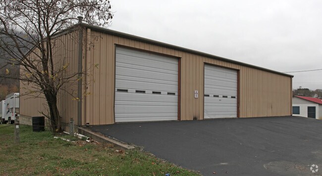
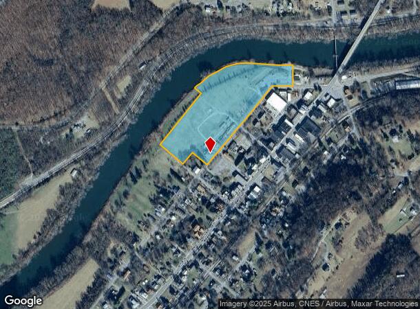
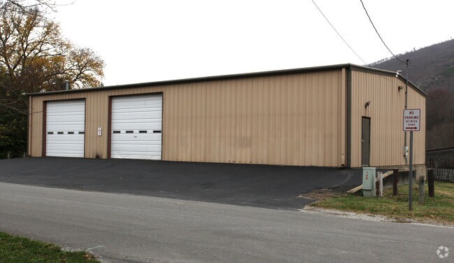
Property Record
485 Lowe St, Buchanan, VA 24066
NEARBY LISTINGS FOR SALE OR LEASE
-
-
View all Buchanan listings for sale on LoopNet.com
Property Detail
485 Lowe St
65A(5)1
BUCHANAN TRACT A
Countyproperty
Botetourt
AE
Virginia
51023C0268C
11.77 AC
2024
Botetourt County
2025
Roanoke
040200
Roanoke, VA
DEMOGRAPHICS near 485 Lowe St
1 Mile
3 Mile
5 Mile
2024 Total Population
887
1,843
3,089
2029 Population
903
1,884
3,177
Pop Growth 2024-2029
+ 1.80%
+ 2.22%
+ 2.85%
Average Age
43
43
44
2024 Total Households
382
784
1,302
HH Growth 2024-2029
+ 1.57%
+ 2.04%
+ 2.76%
Median Household Inc
$54,569
$55,000
$55,745
Avg Household Size
2.30
2.30
2.30
2024 Avg HH Vehicles
2.00
2.00
3.00
Median Home Value
$192,573
$200,867
$206,208
Median Year Built
1972
1973
1974
Nearby Places
Map Layers
Map Styles
 Street
 Aerial
- Restaurants
- Banks
- Shops
- Fitness
- Groceries
PUBLIC TRANSPORTATION
AIRPORT
Roanoke/Blacksburg Regional (Woodrum Field)
DRIVE
WALK
Distance
Roanoke/Blacksburg Regional (Woodrum Field)
36 min
24.7 mi
Lynchburg Regional/Preston Glenn Field
DRIVE
WALK
Distance
Lynchburg Regional/Preston Glenn Field
65 min
40.3 mi
Nearby Properties
Address
Land Use
TOTAL SIZE
Lot Size
Zoning
Address
Land Use
TOTAL SIZE
Lot Size
Zoning
27.59 AC
A1
Address
Land Use
TOTAL SIZE
Lot Size
Zoning
20 AC
T
Address
Land Use
TOTAL SIZE
Lot Size
Zoning
2.83 AC
T
Address
Land Use
TOTAL SIZE
Lot Size
Zoning
34.71 AC
A1
Address
Land Use
TOTAL SIZE
Lot Size
Zoning
2,175 AC
A1
Address
Land Use
TOTAL SIZE
Lot Size
Zoning
22 AC
M-3
Address
Land Use
TOTAL SIZE
Lot Size
Zoning
1.55 AC
4
Address
Land Use
TOTAL SIZE
Lot Size
Zoning
1,728 SF
347.72 AC
A1
Address
Land Use
TOTAL SIZE
Lot Size
Zoning
21.94 AC
A1
Address
Land Use
TOTAL SIZE
Lot Size
Zoning
405.35 AC
A1
Address
Land Use
TOTAL SIZE
Lot Size
Zoning
310.98 AC
A1
Address
Land Use
TOTAL SIZE
Lot Size
Zoning
1.57 AC
RL
Address
Land Use
TOTAL SIZE
Lot Size
Zoning
736 SF
268.23 AC
A1
Address
Land Use
TOTAL SIZE
Lot Size
Zoning
8.89 AC
T
Address
Land Use
TOTAL SIZE
Lot Size
Zoning
0.73 AC
TR
Address
Land Use
TOTAL SIZE
Lot Size
Zoning
4.50 AC
T
Address
Land Use
TOTAL SIZE
Lot Size
Zoning
0.39 AC
RL
Address
Land Use
TOTAL SIZE
Lot Size
Zoning
9,270 SF
0.66 AC
4
Address
Land Use
TOTAL SIZE
Lot Size
Zoning
2.49 AC
T
Address
Land Use
TOTAL SIZE
Lot Size
Zoning
0.30 AC
O
Address
Land Use
TOTAL SIZE
Lot Size
Zoning
24.76 AC
T
Address
Land Use
TOTAL SIZE
Lot Size
Zoning
20.76 AC
B-1
Address
Land Use
TOTAL SIZE
Lot Size
Zoning
0.85 AC
T
Address
Land Use
TOTAL SIZE
Lot Size
Zoning
117.12 AC
M-3
Address
Land Use
TOTAL SIZE
Lot Size
Zoning
3.22 AC
Address
Land Use
TOTAL SIZE
Lot Size
Zoning
8,000 SF
0.98 AC
T
Address
Land Use
TOTAL SIZE
Lot Size
Zoning
0.31 AC
P
Address
Land Use
TOTAL SIZE
Lot Size
Zoning
85.65 AC
A1
Address
Land Use
TOTAL SIZE
Lot Size
Zoning
1.03 AC
T
The World's #1 Commercial Real Estate Marketplace
Connect with us
© 2025 CoStar Group
The information above has been obtained from sources believed reliable. While we do not doubt its accuracy we have not verified it and make no guarantee, warranty or representation about it. It is your responsibility to independently confirm its accuracy and completeness. Any projections, opinions, assumptions, or estimates used are for example only and do not represent the current or future performance of the property. The value of this transaction to you depends on tax and other factors which should be evaluated by your tax, financial, and legal advisors. You and your advisors should conduct a careful, independent investigation of the property to determine to your satisfaction the suitability of the property for your needs.