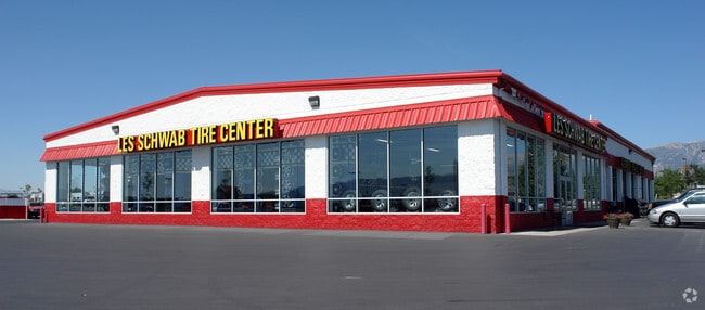
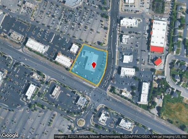
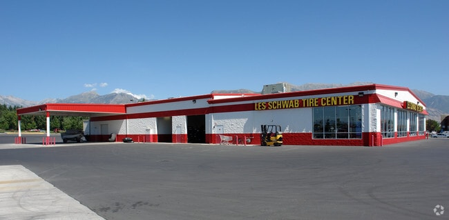
Property Record
485 N 900 W, American Fork, UT 84003
NEARBY LISTINGS FOR SALE OR LEASE
Property Detail
485 N 900 W
Salt Lake City
Ault Commercial Center Sub
Provo-Orem, UT
PART OF LOT 4, PLAT B, AULT COMMERCIAL CENTER SUB DESCRIBED AS FOLLOWS:; COM S 1233.48 FT & W 537.83 FT FR N 1/4 COR. SEC. 15, T5S, R1E, SLB&M.; S 67 DEG 50 41 E 134.58 FT; S 67 DEG 50 41 E 2.5 FT; S 76 DEG 21 43 E 104.69 FT; S 5 DEG 9 22 W 103.78 FT
34-413-0014
Utah
Vehiclerentalsvehiclesales
Utah
2024
4
2025
2.11 AC
000207
Utah County
14,436 SF
DEMOGRAPHICS near 485 N 900 W
1 Mile
3 Mile
5 Mile
2024 Total Population
10,068
82,434
182,470
2029 Population
11,793
96,314
214,120
Pop Growth 2024-2029
+ 17.13%
+ 16.84%
+ 17.35%
Average Age
33
32
31
2024 Total Households
2,823
22,858
50,765
HH Growth 2024-2029
+ 17.50%
+ 17.25%
+ 17.77%
Median Household Inc
$96,360
$101,897
$109,282
Avg Household Size
3.50
3.60
3.60
2024 Avg HH Vehicles
2.00
2.00
2.00
Median Home Value
$499,780
$497,264
$520,368
Median Year Built
1998
2000
2005
Nearby Places
Map Layers
Map Styles
 Street
 Aerial
- Restaurants
- Banks
- Shops
- Fitness
- Groceries
PUBLIC TRANSPORTATION
COMMUTER RAIL
DRIVE
WALK
Distance
6 min
2.4 mi
DRIVE
WALK
Distance
10 min
6.0 mi
AIRPORT
Provo Municipal
DRIVE
WALK
Distance
Provo Municipal
24 min
17.9 mi
Salt Lake City International
DRIVE
WALK
Distance
Salt Lake City International
40 min
34.0 mi
Nearby Properties
Address
Land Use
TOTAL SIZE
Lot Size
Zoning
Address
Land Use
TOTAL SIZE
Lot Size
Zoning
400,684 SF
10.39 AC
Address
Land Use
TOTAL SIZE
Lot Size
Zoning
359,445 SF
6.46 AC
Address
Land Use
TOTAL SIZE
Lot Size
Zoning
305,553 SF
13.08 AC
Address
Land Use
TOTAL SIZE
Lot Size
Zoning
146,939 SF
36.63 AC
Address
Land Use
TOTAL SIZE
Lot Size
Zoning
268,989 SF
12.78 AC
Address
Land Use
TOTAL SIZE
Lot Size
Zoning
8.99 AC
Address
Land Use
TOTAL SIZE
Lot Size
Zoning
227,030 SF
21.91 AC
Address
Land Use
TOTAL SIZE
Lot Size
Zoning
165,821 SF
12.29 AC
Address
Land Use
TOTAL SIZE
Lot Size
Zoning
201,838 SF
8.83 AC
Address
Land Use
TOTAL SIZE
Lot Size
Zoning
182,338 SF
7.97 AC
Address
Land Use
TOTAL SIZE
Lot Size
Zoning
153,790 SF
12.07 AC
Address
Land Use
TOTAL SIZE
Lot Size
Zoning
200,016 SF
8.82 AC
Address
Land Use
TOTAL SIZE
Lot Size
Zoning
122,777 SF
6.68 AC
Address
Land Use
TOTAL SIZE
Lot Size
Zoning
149,937 SF
13.49 AC
Address
Land Use
TOTAL SIZE
Lot Size
Zoning
409,362 SF
29.53 AC
Address
Land Use
TOTAL SIZE
Lot Size
Zoning
143,438 SF
7.43 AC
Address
Land Use
TOTAL SIZE
Lot Size
Zoning
100,814 SF
8.22 AC
Address
Land Use
TOTAL SIZE
Lot Size
Zoning
62,104 SF
8.97 AC
Address
Land Use
TOTAL SIZE
Lot Size
Zoning
110,561 SF
6.47 AC
Address
Land Use
TOTAL SIZE
Lot Size
Zoning
1,121 SF
4.07 AC
Address
Land Use
TOTAL SIZE
Lot Size
Zoning
137,193 SF
12.45 AC
Address
Land Use
TOTAL SIZE
Lot Size
Zoning
70,213 SF
2.14 AC
Address
Land Use
TOTAL SIZE
Lot Size
Zoning
111,292 SF
5.36 AC
Address
Land Use
TOTAL SIZE
Lot Size
Zoning
65,451 SF
6.09 AC
Address
Land Use
TOTAL SIZE
Lot Size
Zoning
100,973 SF
5.71 AC
Address
Land Use
TOTAL SIZE
Lot Size
Zoning
76,420 SF
3.94 AC
Address
Land Use
TOTAL SIZE
Lot Size
Zoning
91,812 SF
6.99 AC
Address
Land Use
TOTAL SIZE
Lot Size
Zoning
124,836 SF
8.74 AC
Address
Land Use
TOTAL SIZE
Lot Size
Zoning
70,678 SF
4.03 AC
Address
Land Use
TOTAL SIZE
Lot Size
Zoning
114,574 SF
6.78 AC
The World's #1 Commercial Real Estate Marketplace
Connect with us
© 2025 CoStar Group
The information above has been obtained from sources believed reliable. While we do not doubt its accuracy we have not verified it and make no guarantee, warranty or representation about it. It is your responsibility to independently confirm its accuracy and completeness. Any projections, opinions, assumptions, or estimates used are for example only and do not represent the current or future performance of the property. The value of this transaction to you depends on tax and other factors which should be evaluated by your tax, financial, and legal advisors. You and your advisors should conduct a careful, independent investigation of the property to determine to your satisfaction the suitability of the property for your needs.