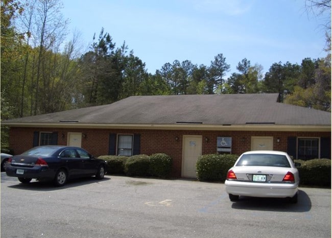
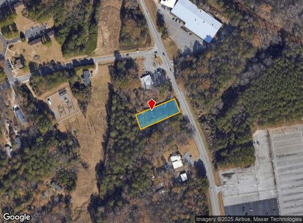
Property Record
485 Newton Bridge Rd, Athens, GA 30607
NEARBY LISTINGS FOR SALE OR LEASE
Property Detail
485 Newton Bridge Rd
112-017-E
Com-St-048->00-03
Medicalbuilding
Clarke
X
Georgia
13059C0015E
0.62 AC
2025
North Athens
2025
Other Market Areas
130300
Athens-Clarke County, GA
4,880 SF
DEMOGRAPHICS near 485 Newton Bridge Rd
1 Mile
3 Mile
5 Mile
2024 Total Population
2,184
46,447
94,355
2029 Population
2,173
46,551
95,141
Pop Growth 2024-2029
(0.50%)
+ 0.22%
+ 0.83%
Average Age
35
33
34
2024 Total Households
683
17,859
36,482
HH Growth 2024-2029
(0.73%)
+ 0.14%
+ 0.80%
Median Household Inc
$40,227
$43,687
$47,370
Avg Household Size
2.80
2.20
2.20
2024 Avg HH Vehicles
2.00
2.00
2.00
Median Home Value
$229,394
$238,718
$258,116
Median Year Built
1988
1981
1984
Nearby Places
Map Layers
Map Styles
 Street
 Aerial
- Restaurants
- Banks
- Shops
- Fitness
- Groceries
Nearby Properties
Address
Land Use
TOTAL SIZE
Lot Size
Zoning
Address
Land Use
TOTAL SIZE
Lot Size
Zoning
11.36 AC
G
Address
Land Use
TOTAL SIZE
Lot Size
Zoning
33.61 AC
G
Address
Land Use
TOTAL SIZE
Lot Size
Zoning
81,812 SF
6.23 AC
C-D (RIV)
Address
Land Use
TOTAL SIZE
Lot Size
Zoning
21.57 AC
G
Address
Land Use
TOTAL SIZE
Lot Size
Zoning
24.70 AC
G
Address
Land Use
TOTAL SIZE
Lot Size
Zoning
163,904 SF
3.75 AC
C-D
Address
Land Use
TOTAL SIZE
Lot Size
Zoning
10,240 SF
6.47 AC
G
Address
Land Use
TOTAL SIZE
Lot Size
Zoning
21.64 AC
G
Address
Land Use
TOTAL SIZE
Lot Size
Zoning
85,608 SF
63.75 AC
RM-2
Address
Land Use
TOTAL SIZE
Lot Size
Zoning
213,612 SF
3.07 AC
C-D
Address
Land Use
TOTAL SIZE
Lot Size
Zoning
184,293 SF
1.84 AC
C-D
Address
Land Use
TOTAL SIZE
Lot Size
Zoning
56.15 AC
G
Address
Land Use
TOTAL SIZE
Lot Size
Zoning
226,339 SF
2.32 AC
C-D (RIV)
Address
Land Use
TOTAL SIZE
Lot Size
Zoning
81,973 SF
4.97 AC
G
Address
Land Use
TOTAL SIZE
Lot Size
Zoning
5,501 SF
1.47 AC
C-D
Address
Land Use
TOTAL SIZE
Lot Size
Zoning
265,400 SF
2.95 AC
C-D
Address
Land Use
TOTAL SIZE
Lot Size
Zoning
15.29 AC
G
Address
Land Use
TOTAL SIZE
Lot Size
Zoning
5.61 AC
G
Address
Land Use
TOTAL SIZE
Lot Size
Zoning
18.47 AC
C-G
Address
Land Use
TOTAL SIZE
Lot Size
Zoning
112,071 SF
5.27 AC
E-O
Address
Land Use
TOTAL SIZE
Lot Size
Zoning
10.71 AC
G
Address
Land Use
TOTAL SIZE
Lot Size
Zoning
60,582 SF
3.11 AC
C-D
Address
Land Use
TOTAL SIZE
Lot Size
Zoning
136,404 SF
1.72 AC
G
Address
Land Use
TOTAL SIZE
Lot Size
Zoning
66,200 SF
13.35 AC
G
Address
Land Use
TOTAL SIZE
Lot Size
Zoning
36.74 AC
G
Address
Land Use
TOTAL SIZE
Lot Size
Zoning
50,000 SF
14.08 AC
G
Address
Land Use
TOTAL SIZE
Lot Size
Zoning
8,357 SF
22.38 AC
RM-2
Address
Land Use
TOTAL SIZE
Lot Size
Zoning
118,239 SF
2.80 AC
C-D(ND)
Address
Land Use
TOTAL SIZE
Lot Size
Zoning
137,661 SF
1.96 AC
C-D
Address
Land Use
TOTAL SIZE
Lot Size
Zoning
125,888 SF
1.11 AC
C-D
The World's #1 Commercial Real Estate Marketplace
Connect with us
© 2025 CoStar Group
The information above has been obtained from sources believed reliable. While we do not doubt its accuracy we have not verified it and make no guarantee, warranty or representation about it. It is your responsibility to independently confirm its accuracy and completeness. Any projections, opinions, assumptions, or estimates used are for example only and do not represent the current or future performance of the property. The value of this transaction to you depends on tax and other factors which should be evaluated by your tax, financial, and legal advisors. You and your advisors should conduct a careful, independent investigation of the property to determine to your satisfaction the suitability of the property for your needs.