Property Record
485 W Northside Dr, Jackson, MS 39206
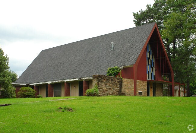

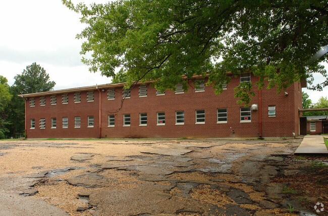
Property Detail
485 W Northside Dr
Jackson, MS
BEG SE COR NORTHSIDE DRIVE & BRITTON AVE S 289.5 FT E 136.92 FT S 60 FT W 136.92 TO E/L OF BRITTON AVE S 60 FT E 151.92 FT S 180 FT E 145.35 FT N 270 FT NE/LY 258 FT TO W/L AZALEA DRIVE NW/LY 257 FT TO S/L NORTHSIDE DR W 350.5 FT TO POB PT LOTS 21 &
0430-0087-000
Hinds
Religious
Mississippi
B and X Area of moderate flood hazard, usually the area between the limits of the 100-year and 500-year floods.
3,21-
0
3 AC
2025
North Jackson
000500
Jackson
22,453 SF
NEARBY LISTINGS FOR SALE OR LEASE
DEMOGRAPHICS near 485 W Northside Dr
1 mile
3 mile
5 mile
2024 Total Population
7,888
49,993
101,450
2029 Population
7,671
48,384
98,897
Pop Growth 2024-2029
(2.75%)
(3.22%)
(2.52%)
Average Age
42
40
39
2024 Total Households
3,449
21,953
43,314
HH Growth 2024-2029
(2.78%)
(3.38%)
(2.67%)
Median Household Inc
$37,255
$41,255
$45,115
Avg Household Size
2.20
2.20
2.20
2024 Avg HH Vehicles
2.00
2.00
2.00
Median Home Value
$81,951
$127,108
$139,083
Median Year Built
1958
1966
1968
Nearby Places
Map Layers
Map Styles
 Street
 Aerial
Transit
 Traffic
 Biking
Places
Listings with unknown addresses are not visible on the map
- Restaurants
- Banks
- Shops
- Fitness
- Groceries
PUBLIC TRANSPORTATION
COMMUTER RAIL
Jackson (City of New Orleans - Amtrak)
Drive
Walk
Distance
Jackson (City of New Orleans - Amtrak)
9 min
5.4 mi
AIRPORT
Jackson-Medgar Wiley Evers International
Drive
Walk
Distance
Jackson-Medgar Wiley Evers International
22 min
12.7 mi
Freight Ports
Port of Greater Baton Rouge
Drive
Walk
Distance
Port of Greater Baton Rouge
204 min
181.0 mi
Nearby Properties
Address
Land Use
TOTAL SIZE
Lot Size
Zoning
Address
Land Use
TOTAL SIZE
Lot Size
Zoning
560,993 SF
47 AC
Address
Land Use
TOTAL SIZE
Lot Size
Zoning
7,561 SF
153.82 AC
Address
Land Use
TOTAL SIZE
Lot Size
Zoning
206,400 SF
7.96 AC
Address
Land Use
TOTAL SIZE
Lot Size
Zoning
10,100 SF
548 AC
Address
Land Use
TOTAL SIZE
Lot Size
Zoning
40,445 SF
3 AC
Address
Land Use
TOTAL SIZE
Lot Size
Zoning
51,260 SF
1 AC
Address
Land Use
TOTAL SIZE
Lot Size
Zoning
33,960 SF
19,602 AC
Address
Land Use
TOTAL SIZE
Lot Size
Zoning
236.80 AC
Address
Land Use
TOTAL SIZE
Lot Size
Zoning
247,574 SF
0.94 AC
Address
Land Use
TOTAL SIZE
Lot Size
Zoning
17,261 SF
18.20 AC
Address
Land Use
TOTAL SIZE
Lot Size
Zoning
32,886 SF
1 AC
Address
Land Use
TOTAL SIZE
Lot Size
Zoning
59,840 SF
2.72 AC
Address
Land Use
TOTAL SIZE
Lot Size
Zoning
16,932 SF
41.60 AC
Address
Land Use
TOTAL SIZE
Lot Size
Zoning
55,160 SF
3 AC
Address
Land Use
TOTAL SIZE
Lot Size
Zoning
31,541 SF
4 AC
Address
Land Use
TOTAL SIZE
Lot Size
Zoning
64,949 SF
3 AC
Address
Land Use
TOTAL SIZE
Lot Size
Zoning
105,600 SF
13 AC
Address
Land Use
TOTAL SIZE
Lot Size
Zoning
54,291 SF
6.99 AC
Address
Land Use
TOTAL SIZE
Lot Size
Zoning
57,234 SF
Address
Land Use
TOTAL SIZE
Lot Size
Zoning
10,620 SF
2.81 AC
Address
Land Use
TOTAL SIZE
Lot Size
Zoning
28.60 AC
Address
Land Use
TOTAL SIZE
Lot Size
Zoning
15,374 SF
0.64 AC
Address
Land Use
TOTAL SIZE
Lot Size
Zoning
230,401 SF
643,381.54 AC
Address
Land Use
TOTAL SIZE
Lot Size
Zoning
4.38 AC
Address
Land Use
TOTAL SIZE
Lot Size
Zoning
20.54 AC
Address
Land Use
TOTAL SIZE
Lot Size
Zoning
33,873 SF
0.96 AC
Address
Land Use
TOTAL SIZE
Lot Size
Zoning
310,650 SF
17 AC
Address
Land Use
TOTAL SIZE
Lot Size
Zoning
23,589 SF
110,808.08 AC
Address
Land Use
TOTAL SIZE
Lot Size
Zoning
29,399 SF
1.04 AC
Address
Land Use
TOTAL SIZE
Lot Size
Zoning
93.67 AC
The World's #1 Commercial Real Estate Marketplace
Connect with us
© 2026 CoStar Group
The information above has been obtained from sources believed reliable. While we do not doubt its accuracy we have not verified it and make no guarantee, warranty or representation about it. It is your responsibility to independently confirm its accuracy and completeness. Any projections, opinions, assumptions, or estimates used are for example only and do not represent the current or future performance of the property. The value of this transaction to you depends on tax and other factors which should be evaluated by your tax, financial, and legal advisors. You and your advisors should conduct a careful, independent investigation of the property to determine to your satisfaction the suitability of the property for your needs.