Property Record
4850 Holopaw Rd, Saint Cloud, FL 34773
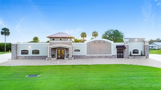

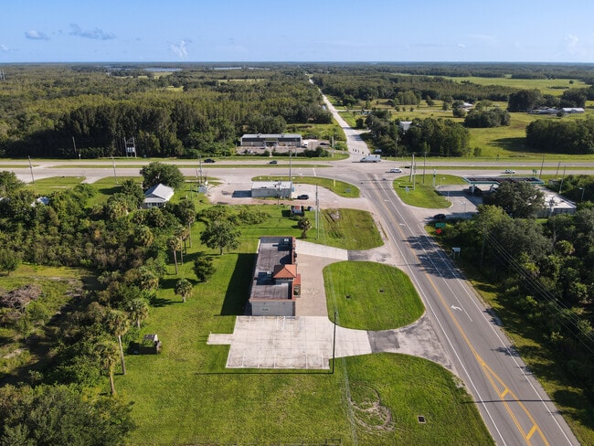

This Property Is For Sale
Property Detail
4850 Holopaw Rd
14-27-32-0000-0020-0000
BEG 208.71 FT S OF SE COR OF JCT OF HWYS 441 & 192, CONT S ALONG RD R/W 258.1 FT, N87 DEG 10 MIN W 155 FT N ALONG 252.3 FT, N 89 DEG 45 MIN E 155 FT TO POB
Officebuilding
Osceola
OAR1
Florida
A Areas with a 1% annual chance of flooding and a 26% chance of flooding over the life of a 30-year mortgage.
20
2024
0.91 AC
2025
Osceola Outlying
043802
Orlando
3,300 SF
Orlando-Kissimmee-Sanford, FL
NEARBY LISTINGS FOR SALE OR LEASE
-
-
View all Saint Cloud listings for sale on LoopNet.com
DEMOGRAPHICS near 4850 Holopaw Rd
1 mile
3 mile
5 mile
2025 Total Population
536
1,609
2,759
2030 Population
637
1,912
3,318
Pop Growth 2025-2030
+ 18.84%
+ 18.83%
+ 20.26%
Average Age
42
42
40
2025 Total Households
201
605
969
HH Growth 2025-2030
+ 19.40%
+ 19.34%
+ 20.64%
Median Household Inc
$62,969
$63,641
$68,624
Avg Household Size
2.70
2.70
2.90
2025 Avg HH Vehicles
3.00
3.00
2.00
Median Home Value
$220,115
$224,193
$270,143
Median Year Built
1999
2000
2007
Nearby Places
Map Layers
Map Styles
 Street
 Aerial
Layers
 Traffic
 Biking
Places
Listings with unknown addresses are not visible on the map
- Restaurants
- Banks
- Shops
- Fitness
- Groceries
PUBLIC TRANSPORTATION
AIRPORT
Melbourne Orlando International
Drive
Walk
Distance
Melbourne Orlando International
42 min
29.5 mi
Orlando International
Drive
Walk
Distance
Orlando International
51 min
32.9 mi
Freight Ports
Port Canaveral
Drive
Walk
Distance
Port Canaveral
71 min
58.1 mi
Nearby Properties
Address
Land Use
TOTAL SIZE
Lot Size
Zoning
Address
Land Use
TOTAL SIZE
Lot Size
Zoning
6,660 SF
431.64 AC
OAC
Address
Land Use
TOTAL SIZE
Lot Size
Zoning
613.94 AC
Address
Land Use
TOTAL SIZE
Lot Size
Zoning
355.90 AC
OPD
Address
Land Use
TOTAL SIZE
Lot Size
Zoning
649.42 AC
OAC
Address
Land Use
TOTAL SIZE
Lot Size
Zoning
253.40 AC
OPD
Address
Land Use
TOTAL SIZE
Lot Size
Zoning
472.57 AC
OAC
Address
Land Use
TOTAL SIZE
Lot Size
Zoning
303.50 AC
OAC
Address
Land Use
TOTAL SIZE
Lot Size
Zoning
9,230 SF
4.17 AC
OCR
Address
Land Use
TOTAL SIZE
Lot Size
Zoning
12,373 SF
1.88 AC
OAC
Address
Land Use
TOTAL SIZE
Lot Size
Zoning
185.06 AC
OAC
Address
Land Use
TOTAL SIZE
Lot Size
Zoning
Address
Land Use
TOTAL SIZE
Lot Size
Zoning
163.30 AC
OAC
Address
Land Use
TOTAL SIZE
Lot Size
Zoning
13,504 SF
33.22 AC
OAC
Address
Land Use
TOTAL SIZE
Lot Size
Zoning
2,476 SF
1 AC
OCR
Address
Land Use
TOTAL SIZE
Lot Size
Zoning
1,600 SF
16.41 AC
OAC
Address
Land Use
TOTAL SIZE
Lot Size
Zoning
6,596 SF
564 AC
OAC
Address
Land Use
TOTAL SIZE
Lot Size
Zoning
1,352 SF
489.51 AC
OAC
Address
Land Use
TOTAL SIZE
Lot Size
Zoning
48.14 AC
OAC
Address
Land Use
TOTAL SIZE
Lot Size
Zoning
3,745 SF
24.89 AC
AC
Address
Land Use
TOTAL SIZE
Lot Size
Zoning
5,000 SF
1.10 AC
Address
Land Use
TOTAL SIZE
Lot Size
Zoning
1,646 SF
1.26 AC
OR1
Address
Land Use
TOTAL SIZE
Lot Size
Zoning
1,760 SF
0.81 AC
OR1
Address
Land Use
TOTAL SIZE
Lot Size
Zoning
720 SF
319.78 AC
OAC
Address
Land Use
TOTAL SIZE
Lot Size
Zoning
80.11 AC
OAC
Address
Land Use
TOTAL SIZE
Lot Size
Zoning
31.85 AC
OAC
Address
Land Use
TOTAL SIZE
Lot Size
Zoning
Address
Land Use
TOTAL SIZE
Lot Size
Zoning
2,010 SF
10.91 AC
OAC
Address
Land Use
TOTAL SIZE
Lot Size
Zoning
11.63 AC
OAC
Address
Land Use
TOTAL SIZE
Lot Size
Zoning
20.01 AC
OAC
The World's #1 Commercial Real Estate Marketplace
Connect with us
© 2026 CoStar Group
The information above has been obtained from sources believed reliable. While we do not doubt its accuracy we have not verified it and make no guarantee, warranty or representation about it. It is your responsibility to independently confirm its accuracy and completeness. Any projections, opinions, assumptions, or estimates used are for example only and do not represent the current or future performance of the property. The value of this transaction to you depends on tax and other factors which should be evaluated by your tax, financial, and legal advisors. You and your advisors should conduct a careful, independent investigation of the property to determine to your satisfaction the suitability of the property for your needs.