Property Record
4850 Old Ironsides Dr, Santa Clara, CA 95054
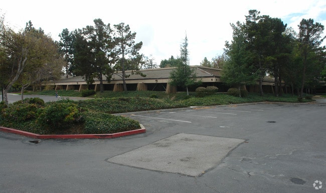

Property Detail
4850 Old Ironsides Dr
San Jose-Sunnyvale-Santa Clara, CA
LOT 8
104-04-064
SANTA CLARA COUNTY
Residentialacreage
California
PD
8
2024
7.27 AC
2025
North Santa Clara
505010
South Bay/San Jose
101,650 SF
NEARBY LISTINGS FOR SALE OR LEASE
DEMOGRAPHICS near 4850 Old Ironsides Dr
1 mile
3 mile
5 mile
2025 Total Population
8,654
133,948
369,780
2030 Population
8,975
137,919
380,394
Pop Growth 2025-2030
+ 3.71%
+ 2.96%
+ 2.87%
Average Age
40
37
37
2025 Total Households
2,841
51,317
139,185
HH Growth 2025-2030
+ 3.94%
+ 3.04%
+ 2.94%
Median Household Inc
$153,688
$187,078
$181,674
Avg Household Size
2.90
2.50
2.60
2025 Avg HH Vehicles
2.00
2.00
2.00
Median Home Value
$1,036,932
$1,072,977
$1,100,933
Median Year Built
1977
1994
1981
Nearby Places
Map Layers
Map Styles
 Street
 Aerial
Layers
 Traffic
 Biking
Places
Listings with unknown addresses are not visible on the map
- Restaurants
- Banks
- Shops
- Fitness
- Groceries
PUBLIC TRANSPORTATION
TRANSIT/SUBWAY
Old Ironsides Station (Mountain View - Alum Rock - VTA, Mountain View - Alum Rock Modified-W - VTA, Old Ironsides - Winchester - VTA)
Drive
Walk
Distance
Old Ironsides Station (Mountain View - Alum Rock - VTA, Mountain View - Alum Rock Modified-W - VTA, Old Ironsides - Winchester - VTA)
0 min
4 min
0.2 mi
Great America Station (Mountain View - Alum Rock - VTA, Mountain View - Alum Rock Modified-W - VTA, Old Ironsides - Winchester - VTA)
Drive
Walk
Distance
Great America Station (Mountain View - Alum Rock - VTA, Mountain View - Alum Rock Modified-W - VTA, Old Ironsides - Winchester - VTA)
2 min
8 min
0.4 mi
Patrick Henry Pocket Track (Not A Public Stop) (Old Ironsides - Winchester - VTA)
Drive
Walk
Distance
Patrick Henry Pocket Track (Not A Public Stop) (Old Ironsides - Winchester - VTA)
1 min
8 min
0.4 mi
Reamwood Station (Mountain View - Alum Rock - VTA, Mountain View - Alum Rock Modified-W - VTA)
Drive
Walk
Distance
Reamwood Station (Mountain View - Alum Rock - VTA, Mountain View - Alum Rock Modified-W - VTA)
1 min
14 min
0.7 mi
COMMUTER RAIL
Great America-Santa Clara (ACE Train - Capitol Corridor Joint Powers Authority, Capitol Corridor - Capitol Corridor Joint Powers Authority)
Drive
Walk
Distance
Great America-Santa Clara (ACE Train - Capitol Corridor Joint Powers Authority, Capitol Corridor - Capitol Corridor Joint Powers Authority)
4 min
19 min
1.0 mi
Lawrence Caltrain Station Southbound (Limited - Caltrain (Caltrain), Local Weekday - Caltrain (Caltrain), Local Weekend - Caltrain (Caltrain))
Drive
Walk
Distance
Lawrence Caltrain Station Southbound (Limited - Caltrain (Caltrain), Local Weekday - Caltrain (Caltrain), Local Weekend - Caltrain (Caltrain))
7 min
3.4 mi
AIRPORT
Norman Y Mineta San Jose International
Drive
Walk
Distance
Norman Y Mineta San Jose International
9 min
4.8 mi
San Francisco International
Drive
Walk
Distance
San Francisco International
39 min
29.9 mi
Metro Oakland International
Drive
Walk
Distance
Metro Oakland International
43 min
33.7 mi
Freight Ports
Port of Redwood City
Drive
Walk
Distance
Port of Redwood City
24 min
16.8 mi
Nearby Properties
Address
Land Use
TOTAL SIZE
Lot Size
Zoning
Address
Land Use
TOTAL SIZE
Lot Size
Zoning
553,793 SF
38.06 AC
ML
Address
Land Use
TOTAL SIZE
Lot Size
Zoning
777,000 SF
17.84 AC
MS
Address
Land Use
TOTAL SIZE
Lot Size
Zoning
0.06 AC
PD
Address
Land Use
TOTAL SIZE
Lot Size
Zoning
424,316 SF
22.37 AC
SU
Address
Land Use
TOTAL SIZE
Lot Size
Zoning
318,172 SF
60.47 AC
MP-TO
Address
Land Use
TOTAL SIZE
Lot Size
Zoning
107,203 SF
21.74 AC
MXD2
Address
Land Use
TOTAL SIZE
Lot Size
Zoning
238,239 SF
24.67 AC
PD
Address
Land Use
TOTAL SIZE
Lot Size
Zoning
111,585 SF
6.69 AC
ML
Address
Land Use
TOTAL SIZE
Lot Size
Zoning
16.72 AC
MSLSP
Address
Land Use
TOTAL SIZE
Lot Size
Zoning
636,145 SF
9.44 AC
IP
Address
Land Use
TOTAL SIZE
Lot Size
Zoning
181,562 SF
16.51 AC
ML
Address
Land Use
TOTAL SIZE
Lot Size
Zoning
818,051 SF
13.81 AC
CP
Address
Land Use
TOTAL SIZE
Lot Size
Zoning
73,425 SF
14.20 AC
MS
Address
Land Use
TOTAL SIZE
Lot Size
Zoning
181,709 SF
24.01 AC
MPI
Address
Land Use
TOTAL SIZE
Lot Size
Zoning
81,250 SF
14.73 AC
MPT
Address
Land Use
TOTAL SIZE
Lot Size
Zoning
23.19 AC
MP-I
Address
Land Use
TOTAL SIZE
Lot Size
Zoning
180,846 SF
12.19 AC
ML
Address
Land Use
TOTAL SIZE
Lot Size
Zoning
17.25 AC
MPI
Address
Land Use
TOTAL SIZE
Lot Size
Zoning
530,457 SF
6.71 AC
A(PD)
Address
Land Use
TOTAL SIZE
Lot Size
Zoning
162,205 SF
18.69 AC
MS
Address
Land Use
TOTAL SIZE
Lot Size
Zoning
107.73 AC
CT
Address
Land Use
TOTAL SIZE
Lot Size
Zoning
208,562 SF
9.10 AC
CP
Address
Land Use
TOTAL SIZE
Lot Size
Zoning
23,709 SF
7.48 AC
PPSP
Address
Land Use
TOTAL SIZE
Lot Size
Zoning
22,400 SF
11.43 AC
MP-TO
Address
Land Use
TOTAL SIZE
Lot Size
Zoning
22.40 AC
PD
Address
Land Use
TOTAL SIZE
Lot Size
Zoning
22.40 AC
PD
Address
Land Use
TOTAL SIZE
Lot Size
Zoning
309,559 SF
5.69 AC
ML
Address
Land Use
TOTAL SIZE
Lot Size
Zoning
577,107 SF
3.65 AC
ML
Address
Land Use
TOTAL SIZE
Lot Size
Zoning
8.22 AC
PD
The World's #1 Commercial Real Estate Marketplace
Connect with us
© 2026 CoStar Group
The information above has been obtained from sources believed reliable. While we do not doubt its accuracy we have not verified it and make no guarantee, warranty or representation about it. It is your responsibility to independently confirm its accuracy and completeness. Any projections, opinions, assumptions, or estimates used are for example only and do not represent the current or future performance of the property. The value of this transaction to you depends on tax and other factors which should be evaluated by your tax, financial, and legal advisors. You and your advisors should conduct a careful, independent investigation of the property to determine to your satisfaction the suitability of the property for your needs.