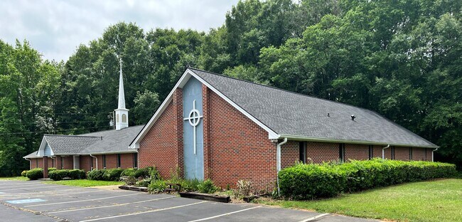
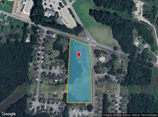
Property Record
4850 Sweetwater Valley Rd, Austell, GA 30106
NEARBY LISTINGS FOR SALE OR LEASE
Property Detail
4850 Sweetwater Valley Rd
19-1135-002
Cobb
Religious
Georgia
X
5 AC
13067C0184H
Douglasville/Lithia Springs
2024
Atlanta
2025
Atlanta-Sandy Springs-Roswell, GA
031409
DEMOGRAPHICS near 4850 Sweetwater Valley Rd
1 Mile
3 Mile
5 Mile
2024 Total Population
5,392
51,627
146,681
2029 Population
5,453
52,595
149,746
Pop Growth 2024-2029
+ 1.13%
+ 1.87%
+ 2.09%
Average Age
38
39
39
2024 Total Households
1,940
18,738
52,877
HH Growth 2024-2029
+ 1.08%
+ 1.80%
+ 2.07%
Median Household Inc
$67,836
$66,398
$71,591
Avg Household Size
2.70
2.70
2.70
2024 Avg HH Vehicles
2.00
2.00
2.00
Median Home Value
$214,040
$217,967
$247,185
Median Year Built
1980
1986
1988
Nearby Places
Map Layers
Map Styles
 Street
 Aerial
- Restaurants
- Banks
- Shops
- Fitness
- Groceries
PUBLIC TRANSPORTATION
AIRPORT
Hartsfield - Jackson Atlanta International
DRIVE
WALK
Distance
Hartsfield - Jackson Atlanta International
43 min
27.6 mi
Freight Ports
Georgia Ports - Savannah
DRIVE
WALK
Distance
Georgia Ports - Savannah
306 min
266.9 mi
SALE & LEASE HISTORY
LISTING DATE
SALE/LEASE

Jul 15, 2022
For Sale
Nearby Properties
Address
Land Use
TOTAL SIZE
Lot Size
Zoning
Address
Land Use
TOTAL SIZE
Lot Size
Zoning
494,972 SF
25.60 AC
CF
Address
Land Use
TOTAL SIZE
Lot Size
Zoning
403,898 SF
37.53 AC
RM-12
Address
Land Use
TOTAL SIZE
Lot Size
Zoning
25,956 SF
12.78 AC
PVC
Address
Land Use
TOTAL SIZE
Lot Size
Zoning
272,170 SF
26.40 AC
RM-12
Address
Land Use
TOTAL SIZE
Lot Size
Zoning
238,984 SF
17.51 AC
RM-12
Address
Land Use
TOTAL SIZE
Lot Size
Zoning
Address
Land Use
TOTAL SIZE
Lot Size
Zoning
209,649 SF
13.51 AC
RM-12
Address
Land Use
TOTAL SIZE
Lot Size
Zoning
219,402 SF
10.33 AC
RM-12
Address
Land Use
TOTAL SIZE
Lot Size
Zoning
151,436 SF
11.42 AC
RM-12
Address
Land Use
TOTAL SIZE
Lot Size
Zoning
179,048 SF
25.97 AC
RM-12
Address
Land Use
TOTAL SIZE
Lot Size
Zoning
118,069 SF
0.38 AC
OI
Address
Land Use
TOTAL SIZE
Lot Size
Zoning
188,988 SF
15.30 AC
OI
Address
Land Use
TOTAL SIZE
Lot Size
Zoning
92,468 SF
13.69 AC
RM-8
Address
Land Use
TOTAL SIZE
Lot Size
Zoning
78.60 AC
R20
Address
Land Use
TOTAL SIZE
Lot Size
Zoning
98,574 SF
10.27 AC
CRC
Address
Land Use
TOTAL SIZE
Lot Size
Zoning
170,892 SF
29.16 AC
CRC/LRO
Address
Land Use
TOTAL SIZE
Lot Size
Zoning
79,348 SF
12.04 AC
CRC
Address
Land Use
TOTAL SIZE
Lot Size
Zoning
115,088 SF
18.24 AC
PUD
Address
Land Use
TOTAL SIZE
Lot Size
Zoning
134,592 SF
13.43 AC
CBD
Address
Land Use
TOTAL SIZE
Lot Size
Zoning
2,636 SF
2.97 AC
NRC
Address
Land Use
TOTAL SIZE
Lot Size
Zoning
104,538 SF
9.18 AC
RM-12
Address
Land Use
TOTAL SIZE
Lot Size
Zoning
44,097 SF
3.45 AC
OI
Address
Land Use
TOTAL SIZE
Lot Size
Zoning
38,418 SF
2.27 AC
GC
Address
Land Use
TOTAL SIZE
Lot Size
Zoning
175,923 SF
12.75 AC
GC
Address
Land Use
TOTAL SIZE
Lot Size
Zoning
122,323 SF
9.39 AC
CRC/WS
Address
Land Use
TOTAL SIZE
Lot Size
Zoning
40,600 SF
4.99 AC
NS/WS
Address
Land Use
TOTAL SIZE
Lot Size
Zoning
105,824 SF
14.92 AC
CRC
Address
Land Use
TOTAL SIZE
Lot Size
Zoning
60,630 SF
6.78 AC
CRC/WS
Address
Land Use
TOTAL SIZE
Lot Size
Zoning
12.01 AC
CRC
Address
Land Use
TOTAL SIZE
Lot Size
Zoning
80,572 SF
8.39 AC
GC
The World's #1 Commercial Real Estate Marketplace
Connect with us
© 2025 CoStar Group
The information above has been obtained from sources believed reliable. While we do not doubt its accuracy we have not verified it and make no guarantee, warranty or representation about it. It is your responsibility to independently confirm its accuracy and completeness. Any projections, opinions, assumptions, or estimates used are for example only and do not represent the current or future performance of the property. The value of this transaction to you depends on tax and other factors which should be evaluated by your tax, financial, and legal advisors. You and your advisors should conduct a careful, independent investigation of the property to determine to your satisfaction the suitability of the property for your needs.