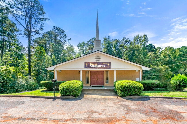
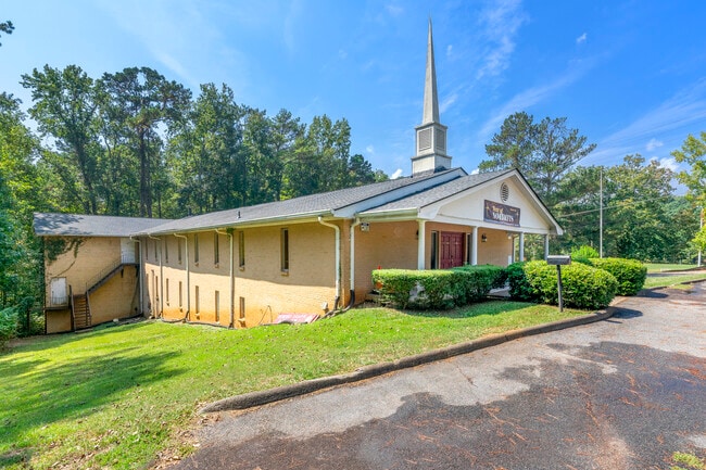
Property Record
4851 River Rd, Ellenwood, GA 30294

NEARBY LISTINGS FOR SALE OR LEASE
-
-
View all Ellenwood listings for sale on LoopNet.com
Property Detail
4851 River Rd
15-031-02-004
800 X 311 X 252 . . . . . . . . . 16.52AC 9-10-91
Religious
DeKalb
X
Georgia
13151C0040D
4
2025
6.83 AC
2025
I-20 East/Conyers
023437
Atlanta
41,057 SF
Atlanta-Sandy Springs-Roswell, GA
DEMOGRAPHICS near 4851 River Rd
1 Mile
3 Mile
5 Mile
2024 Total Population
5,443
43,227
127,787
2029 Population
5,449
43,508
128,355
Pop Growth 2024-2029
+ 0.11%
+ 0.65%
+ 0.44%
Average Age
42
42
40
2024 Total Households
1,833
15,217
46,482
HH Growth 2024-2029
+ 0.11%
+ 0.57%
+ 0.37%
Median Household Inc
$87,764
$73,236
$64,113
Avg Household Size
2.90
2.80
2.70
2024 Avg HH Vehicles
2.00
2.00
2.00
Median Home Value
$253,866
$221,668
$206,214
Median Year Built
2000
1990
1991
Nearby Places
Map Layers
Map Styles
 Street
 Aerial
- Restaurants
- Banks
- Shops
- Fitness
- Groceries
PUBLIC TRANSPORTATION
AIRPORT
Hartsfield - Jackson Atlanta International
DRIVE
WALK
Distance
Hartsfield - Jackson Atlanta International
31 min
16.7 mi
Freight Ports
Georgia Ports - Savannah
DRIVE
WALK
Distance
Georgia Ports - Savannah
273 min
238.5 mi
SALE & LEASE HISTORY
LISTING DATE
SALE/LEASE

May 27, 2025
For Sale
Nearby Properties
Address
Land Use
TOTAL SIZE
Lot Size
Zoning
Address
Land Use
TOTAL SIZE
Lot Size
Zoning
284,650 SF
21.75 AC
R100
Address
Land Use
TOTAL SIZE
Lot Size
Zoning
174,027 SF
35.37 AC
R100
Address
Land Use
TOTAL SIZE
Lot Size
Zoning
86,140 SF
61.60 AC
R100
Address
Land Use
TOTAL SIZE
Lot Size
Zoning
71,383 SF
9.05 AC
NS
Address
Land Use
TOTAL SIZE
Lot Size
Zoning
38,919 SF
13.23 AC
C1
Address
Land Use
TOTAL SIZE
Lot Size
Zoning
111,885 SF
8.49 AC
X
Address
Land Use
TOTAL SIZE
Lot Size
Zoning
55,582 SF
8.50 AC
X
Address
Land Use
TOTAL SIZE
Lot Size
Zoning
80,431 SF
9.53 AC
C2
Address
Land Use
TOTAL SIZE
Lot Size
Zoning
101,848 SF
19.95 AC
C1
Address
Land Use
TOTAL SIZE
Lot Size
Zoning
5,320 SF
1,148.42 AC
X
Address
Land Use
TOTAL SIZE
Lot Size
Zoning
66,900 SF
6.29 AC
C1
Address
Land Use
TOTAL SIZE
Lot Size
Zoning
4,288 SF
77.44 AC
M2
Address
Land Use
TOTAL SIZE
Lot Size
Zoning
65,023 SF
9.74 AC
C1
Address
Land Use
TOTAL SIZE
Lot Size
Zoning
82,557 SF
4.89 AC
C3
Address
Land Use
TOTAL SIZE
Lot Size
Zoning
18,340 SF
2.62 AC
C1
Address
Land Use
TOTAL SIZE
Lot Size
Zoning
62,520 SF
18.01 AC
Address
Land Use
TOTAL SIZE
Lot Size
Zoning
12,848 SF
1.22 AC
C1
Address
Land Use
TOTAL SIZE
Lot Size
Zoning
16,441 SF
11 AC
X
Address
Land Use
TOTAL SIZE
Lot Size
Zoning
19,412 SF
3 AC
C1
Address
Land Use
TOTAL SIZE
Lot Size
Zoning
16,184 SF
2.53 AC
X
Address
Land Use
TOTAL SIZE
Lot Size
Zoning
54,142 SF
7.20 AC
C3
Address
Land Use
TOTAL SIZE
Lot Size
Zoning
6,141 SF
1 AC
C1
Address
Land Use
TOTAL SIZE
Lot Size
Zoning
11.61 AC
Address
Land Use
TOTAL SIZE
Lot Size
Zoning
131,929 SF
6.59 AC
C3
Address
Land Use
TOTAL SIZE
Lot Size
Zoning
176,419 SF
37.18 AC
R100
Address
Land Use
TOTAL SIZE
Lot Size
Zoning
62.41 AC
R100
Address
Land Use
TOTAL SIZE
Lot Size
Zoning
10,020 SF
3.14 AC
TND
Address
Land Use
TOTAL SIZE
Lot Size
Zoning
3,124 SF
0.88 AC
NS
Address
Land Use
TOTAL SIZE
Lot Size
Zoning
8,262 SF
0.99 AC
C-1
Address
Land Use
TOTAL SIZE
Lot Size
Zoning
12,996 SF
1.71 AC
C1
The World's #1 Commercial Real Estate Marketplace
Connect with us
© 2026 CoStar Group
The information above has been obtained from sources believed reliable. While we do not doubt its accuracy we have not verified it and make no guarantee, warranty or representation about it. It is your responsibility to independently confirm its accuracy and completeness. Any projections, opinions, assumptions, or estimates used are for example only and do not represent the current or future performance of the property. The value of this transaction to you depends on tax and other factors which should be evaluated by your tax, financial, and legal advisors. You and your advisors should conduct a careful, independent investigation of the property to determine to your satisfaction the suitability of the property for your needs.