Property Record
4851 W Stamford St, Abilene, TX 79603


Save to a Folder
{{folder.Name}}
{{folder.ListingIds.length}} Properties
{{folder.ListingIds.length}} Property
Create a New Folder
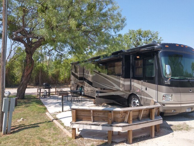
Property Detail
4851 W Stamford St
Abilene, TX
KOA SUB, BLOCK A, LOT 1-2, ACRES 7.966, MH LABEL# NTA1821775/NTA1821776
33413
Taylor
Multipleuses
Texas
AE The base floodplain where base flood elevations are provided. AE Zones are now used on new format FIRMs instead of A1-A30 Zones.
1-2
2024
7.97 AC
2025
North Abilene
013100
Other Market Areas
5,140 SF
NEARBY LISTINGS FOR SALE OR LEASE
-
-
View all Abilene listings for sale on LoopNet.com
DEMOGRAPHICS near 4851 W Stamford St
1 mile
3 mile
5 mile
2025 Total Population
2,672
38,950
87,528
2030 Population
2,746
40,271
91,255
Pop Growth 2025-2030
+ 2.77%
+ 3.39%
+ 4.26%
Average Age
38
37
36
2025 Total Households
933
14,326
33,142
HH Growth 2025-2030
+ 3.11%
+ 3.66%
+ 4.45%
Median Household Inc
$60,285
$52,316
$54,117
Avg Household Size
2.70
2.50
2.40
2025 Avg HH Vehicles
2.00
2.00
2.00
Median Home Value
$151,219
$113,515
$147,158
Median Year Built
1964
1957
1963
Nearby Places
Map Layers
Map Styles
 Street
 Aerial
Layers
 Traffic
 Biking
Places
Listings with unknown addresses are not visible on the map
- Restaurants
- Banks
- Shops
- Fitness
- Groceries
PUBLIC TRANSPORTATION
AIRPORT
Abilene Regional
Drive
Walk
Distance
Abilene Regional
18 min
11.7 mi
Freight Ports
Calhoun Port
Drive
Walk
Distance
Calhoun Port
439 min
378.1 mi
SALE & LEASE HISTORY
LISTING DATE
SALE/LEASE

Jan 29, 2020
For Sale
Nearby Properties
Address
Land Use
TOTAL SIZE
Lot Size
Zoning
Address
Land Use
TOTAL SIZE
Lot Size
Zoning
24.36 AC
Address
Land Use
TOTAL SIZE
Lot Size
Zoning
183,321 SF
11.67 AC
Address
Land Use
TOTAL SIZE
Lot Size
Zoning
141,777 SF
36.78 AC
Address
Land Use
TOTAL SIZE
Lot Size
Zoning
95,893 SF
15.89 AC
Address
Land Use
TOTAL SIZE
Lot Size
Zoning
144,349 SF
11.07 AC
Address
Land Use
TOTAL SIZE
Lot Size
Zoning
342,750 SF
34.54 AC
Address
Land Use
TOTAL SIZE
Lot Size
Zoning
176,378 SF
36.99 AC
Address
Land Use
TOTAL SIZE
Lot Size
Zoning
73,947 SF
9.89 AC
Address
Land Use
TOTAL SIZE
Lot Size
Zoning
75,482 SF
137.60 AC
Address
Land Use
TOTAL SIZE
Lot Size
Zoning
2.63 AC
Address
Land Use
TOTAL SIZE
Lot Size
Zoning
161,050 SF
12.18 AC
Address
Land Use
TOTAL SIZE
Lot Size
Zoning
62,823 SF
9.39 AC
Address
Land Use
TOTAL SIZE
Lot Size
Zoning
155,780 SF
18.80 AC
Address
Land Use
TOTAL SIZE
Lot Size
Zoning
2.63 AC
Address
Land Use
TOTAL SIZE
Lot Size
Zoning
115,042 SF
7.68 AC
Address
Land Use
TOTAL SIZE
Lot Size
Zoning
115,808 SF
5.21 AC
Address
Land Use
TOTAL SIZE
Lot Size
Zoning
241,784 SF
24.28 AC
Address
Land Use
TOTAL SIZE
Lot Size
Zoning
117,126 SF
7.22 AC
Address
Land Use
TOTAL SIZE
Lot Size
Zoning
120,789 SF
2.41 AC
Address
Land Use
TOTAL SIZE
Lot Size
Zoning
25,796 SF
3.65 AC
Address
Land Use
TOTAL SIZE
Lot Size
Zoning
11,200 SF
0.82 AC
Address
Land Use
TOTAL SIZE
Lot Size
Zoning
37,163 SF
4.41 AC
Address
Land Use
TOTAL SIZE
Lot Size
Zoning
171,428 SF
17.31 AC
Address
Land Use
TOTAL SIZE
Lot Size
Zoning
68,610 SF
11.99 AC
Address
Land Use
TOTAL SIZE
Lot Size
Zoning
52,095 SF
16.95 AC
Address
Land Use
TOTAL SIZE
Lot Size
Zoning
50,330 SF
5.44 AC
Address
Land Use
TOTAL SIZE
Lot Size
Zoning
117,729 SF
12.38 AC
Address
Land Use
TOTAL SIZE
Lot Size
Zoning
60,886 SF
4.79 AC
Address
Land Use
TOTAL SIZE
Lot Size
Zoning
99,358 SF
7.74 AC
Address
Land Use
TOTAL SIZE
Lot Size
Zoning
123,203 SF
12.50 AC
The World's #1 Commercial Real Estate Marketplace
Connect with us
© 2026 CoStar Group
The information above has been obtained from sources believed reliable. While we do not doubt its accuracy we have not verified it and make no guarantee, warranty or representation about it. It is your responsibility to independently confirm its accuracy and completeness. Any projections, opinions, assumptions, or estimates used are for example only and do not represent the current or future performance of the property. The value of this transaction to you depends on tax and other factors which should be evaluated by your tax, financial, and legal advisors. You and your advisors should conduct a careful, independent investigation of the property to determine to your satisfaction the suitability of the property for your needs.