Property Record
4854 Macland Rd, Hiram, GA 30141
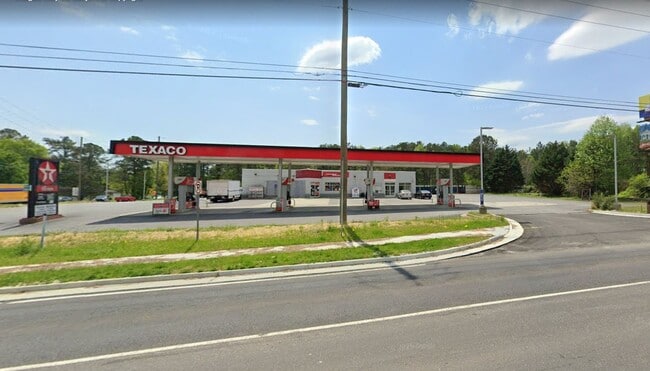

Property Detail
4854 Macland Rd
144.1.3.012.0000
REAL PROPERTY
Storebuilding
PAULDING
B2-0
Georgia
B and X Area of moderate flood hazard, usually the area between the limits of the 100-year and 500-year floods.
441
2025
1.12 AC
2025
Paulding Cnty/Dallas
120206
Atlanta
4,345 SF
Atlanta-Sandy Springs-Roswell, GA
NEARBY LISTINGS FOR SALE OR LEASE
DEMOGRAPHICS near 4854 Macland Rd
1 mile
3 mile
5 mile
2025 Total Population
1,660
39,350
105,690
2030 Population
1,795
41,758
111,907
Pop Growth 2025-2030
+ 8.13%
+ 6.12%
+ 5.88%
Average Age
40
40
40
2025 Total Households
588
13,943
36,600
HH Growth 2025-2030
+ 8.16%
+ 6.34%
+ 6.08%
Median Household Inc
$82,812
$102,817
$103,717
Avg Household Size
2.80
2.80
2.80
2025 Avg HH Vehicles
2.00
2.00
2.00
Median Home Value
$278,323
$386,789
$382,442
Median Year Built
1997
1997
1996
Nearby Places
Map Layers
Map Styles
 Street
 Aerial
Layers
 Traffic
 Biking
Places
Listings with unknown addresses are not visible on the map
- Restaurants
- Banks
- Shops
- Fitness
- Groceries
PUBLIC TRANSPORTATION
AIRPORT
Hartsfield - Jackson Atlanta International
Drive
Walk
Distance
Hartsfield - Jackson Atlanta International
51 min
34.1 mi
Nearby Properties
Address
Land Use
TOTAL SIZE
Lot Size
Zoning
Address
Land Use
TOTAL SIZE
Lot Size
Zoning
46.05 AC
Address
Land Use
TOTAL SIZE
Lot Size
Zoning
126,638 SF
20.26 AC
R4
Address
Land Use
TOTAL SIZE
Lot Size
Zoning
25.10 AC
Address
Land Use
TOTAL SIZE
Lot Size
Zoning
37.28 AC
Address
Land Use
TOTAL SIZE
Lot Size
Zoning
15.02 AC
Address
Land Use
TOTAL SIZE
Lot Size
Zoning
203,706 SF
111.50 AC
Address
Land Use
TOTAL SIZE
Lot Size
Zoning
171,510 SF
7.63 AC
MXU
Address
Land Use
TOTAL SIZE
Lot Size
Zoning
238,291 SF
22.51 AC
B2
Address
Land Use
TOTAL SIZE
Lot Size
Zoning
Address
Land Use
TOTAL SIZE
Lot Size
Zoning
141,658 SF
17.36 AC
PSC
Address
Land Use
TOTAL SIZE
Lot Size
Zoning
223,686 SF
30.20 AC
B2
Address
Land Use
TOTAL SIZE
Lot Size
Zoning
138,725 SF
11.66 AC
B2
Address
Land Use
TOTAL SIZE
Lot Size
Zoning
198,684 SF
21.34 AC
B2
Address
Land Use
TOTAL SIZE
Lot Size
Zoning
151,906 SF
21.07 AC
B2
Address
Land Use
TOTAL SIZE
Lot Size
Zoning
171,184 SF
14.63 AC
PSC
Address
Land Use
TOTAL SIZE
Lot Size
Zoning
99,972 SF
3.18 AC
NRC/O&I
Address
Land Use
TOTAL SIZE
Lot Size
Zoning
83,054 SF
11.06 AC
NRC/WS
Address
Land Use
TOTAL SIZE
Lot Size
Zoning
133,006 SF
15.53 AC
PSC
Address
Land Use
TOTAL SIZE
Lot Size
Zoning
67,341 SF
9.07 AC
GC
Address
Land Use
TOTAL SIZE
Lot Size
Zoning
136,556 SF
7.24 AC
B2
Address
Land Use
TOTAL SIZE
Lot Size
Zoning
44,972 SF
7.81 AC
B2
Address
Land Use
TOTAL SIZE
Lot Size
Zoning
202,176 SF
24.10 AC
R-30
Address
Land Use
TOTAL SIZE
Lot Size
Zoning
71,301 SF
3.88 AC
B1
Address
Land Use
TOTAL SIZE
Lot Size
Zoning
103,185 SF
13.41 AC
B2
Address
Land Use
TOTAL SIZE
Lot Size
Zoning
109,540 SF
13.99 AC
B2
Address
Land Use
TOTAL SIZE
Lot Size
Zoning
185,183 SF
6.99 AC
OI
Address
Land Use
TOTAL SIZE
Lot Size
Zoning
74,036 SF
23.20 AC
B2
Address
Land Use
TOTAL SIZE
Lot Size
Zoning
68,669 SF
7.95 AC
B1
Address
Land Use
TOTAL SIZE
Lot Size
Zoning
367,298 SF
15.38 AC
LI
Address
Land Use
TOTAL SIZE
Lot Size
Zoning
86,556 SF
8.10 AC
PSC
The World's #1 Commercial Real Estate Marketplace
Connect with us
© 2026 CoStar Group
The information above has been obtained from sources believed reliable. While we do not doubt its accuracy we have not verified it and make no guarantee, warranty or representation about it. It is your responsibility to independently confirm its accuracy and completeness. Any projections, opinions, assumptions, or estimates used are for example only and do not represent the current or future performance of the property. The value of this transaction to you depends on tax and other factors which should be evaluated by your tax, financial, and legal advisors. You and your advisors should conduct a careful, independent investigation of the property to determine to your satisfaction the suitability of the property for your needs.