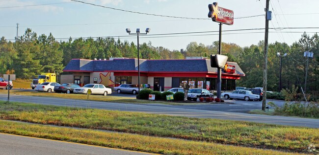
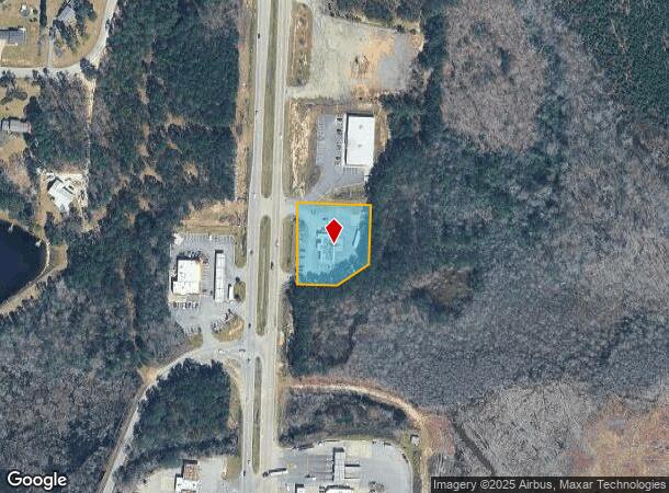
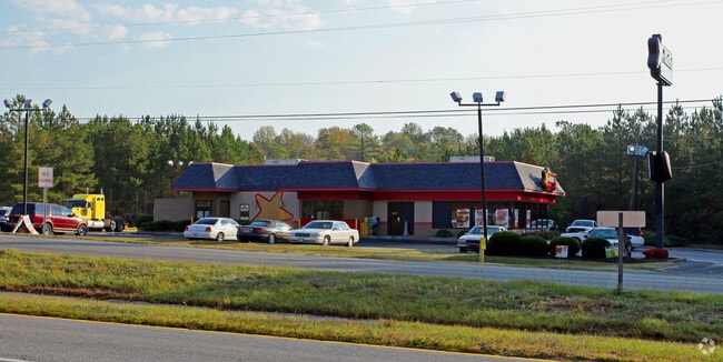
Property Record
486 Highway 601 S, Lugoff, SC 29078
NEARBY LISTINGS FOR SALE OR LEASE
Property Detail
486 Highway 601 S
324-00-00-042
350-270 US HWY NO 601
Restaurantdrivein
Kershaw
X
South Carolina
45055C0435F
0.96 AC
2025
Kershaw County
2025
Columbia
970403
Columbia, SC
3,106 SF
DEMOGRAPHICS near 486 Highway 601 S
1 Mile
3 Mile
5 Mile
2024 Total Population
439
6,572
16,221
2029 Population
471
7,084
17,555
Pop Growth 2024-2029
+ 7.29%
+ 7.79%
+ 8.22%
Average Age
41
41
40
2024 Total Households
172
2,569
6,226
HH Growth 2024-2029
+ 6.98%
+ 7.63%
+ 8.11%
Median Household Inc
$48,472
$46,400
$47,518
Avg Household Size
2.60
2.50
2.60
2024 Avg HH Vehicles
2.00
2.00
2.00
Median Home Value
$160,256
$158,941
$164,381
Median Year Built
1990
1991
1996
Nearby Places
Map Layers
Map Styles
 Street
 Aerial
- Restaurants
- Banks
- Shops
- Fitness
- Groceries
PUBLIC TRANSPORTATION
COMMUTER RAIL
Camden Amtrak Station (Silver Star - Amtrak)
DRIVE
WALK
Distance
Camden Amtrak Station (Silver Star - Amtrak)
11 min
6.2 mi
Freight Ports
North Charleston Terminal
DRIVE
WALK
Distance
North Charleston Terminal
149 min
130.4 mi
Nearby Properties
Address
Land Use
TOTAL SIZE
Lot Size
Zoning
Address
Land Use
TOTAL SIZE
Lot Size
Zoning
539,600 SF
20.47 AC
I1
Address
Land Use
TOTAL SIZE
Lot Size
Zoning
390,425 SF
24.06 AC
I1
Address
Land Use
TOTAL SIZE
Lot Size
Zoning
72,502 SF
12 AC
GD
Address
Land Use
TOTAL SIZE
Lot Size
Zoning
41,160 SF
3.37 AC
Address
Land Use
TOTAL SIZE
Lot Size
Zoning
164,000 SF
25 AC
I1
Address
Land Use
TOTAL SIZE
Lot Size
Zoning
56,876 SF
67.13 AC
Address
Land Use
TOTAL SIZE
Lot Size
Zoning
31,087 SF
9.63 AC
GD
Address
Land Use
TOTAL SIZE
Lot Size
Zoning
3.93 AC
B2
Address
Land Use
TOTAL SIZE
Lot Size
Zoning
87,548 SF
10 AC
GD
Address
Land Use
TOTAL SIZE
Lot Size
Zoning
82,820 SF
8.67 AC
I1
Address
Land Use
TOTAL SIZE
Lot Size
Zoning
64,714 SF
5.93 AC
B2
Address
Land Use
TOTAL SIZE
Lot Size
Zoning
20,359 SF
5.39 AC
RD2
Address
Land Use
TOTAL SIZE
Lot Size
Zoning
35,700 SF
2.03 AC
B2
Address
Land Use
TOTAL SIZE
Lot Size
Zoning
25,953 SF
5.63 AC
B2
Address
Land Use
TOTAL SIZE
Lot Size
Zoning
76,800 SF
5.45 AC
I1
Address
Land Use
TOTAL SIZE
Lot Size
Zoning
15,040 SF
2.52 AC
B2
Address
Land Use
TOTAL SIZE
Lot Size
Zoning
31,700 SF
17.76 AC
GD
Address
Land Use
TOTAL SIZE
Lot Size
Zoning
14,556 SF
4.05 AC
GD
Address
Land Use
TOTAL SIZE
Lot Size
Zoning
61,212 SF
18.36 AC
GD
Address
Land Use
TOTAL SIZE
Lot Size
Zoning
55,125 SF
14.31 AC
I1
Address
Land Use
TOTAL SIZE
Lot Size
Zoning
40,100 SF
5.19 AC
B2
Address
Land Use
TOTAL SIZE
Lot Size
Zoning
46,624 SF
26.64 AC
I1
Address
Land Use
TOTAL SIZE
Lot Size
Zoning
11,076 SF
2.10 AC
Address
Land Use
TOTAL SIZE
Lot Size
Zoning
7,260 SF
1.90 AC
GD
Address
Land Use
TOTAL SIZE
Lot Size
Zoning
66,790 SF
6.43 AC
GD
Address
Land Use
TOTAL SIZE
Lot Size
Zoning
12.77 AC
GD
Address
Land Use
TOTAL SIZE
Lot Size
Zoning
6,597 SF
5.53 AC
GD
Address
Land Use
TOTAL SIZE
Lot Size
Zoning
33,500 SF
2.69 AC
GD
Address
Land Use
TOTAL SIZE
Lot Size
Zoning
36.33 AC
Address
Land Use
TOTAL SIZE
Lot Size
Zoning
1,992 SF
3.43 AC
GD
The World's #1 Commercial Real Estate Marketplace
Connect with us
© 2025 CoStar Group
The information above has been obtained from sources believed reliable. While we do not doubt its accuracy we have not verified it and make no guarantee, warranty or representation about it. It is your responsibility to independently confirm its accuracy and completeness. Any projections, opinions, assumptions, or estimates used are for example only and do not represent the current or future performance of the property. The value of this transaction to you depends on tax and other factors which should be evaluated by your tax, financial, and legal advisors. You and your advisors should conduct a careful, independent investigation of the property to determine to your satisfaction the suitability of the property for your needs.