Property Record
4860 Route 430, Bemus Point, NY 14712
NEARBY LISTINGS FOR SALE OR LEASE
-
-
View all Bemus Point listings for sale on LoopNet.com
Property Detail
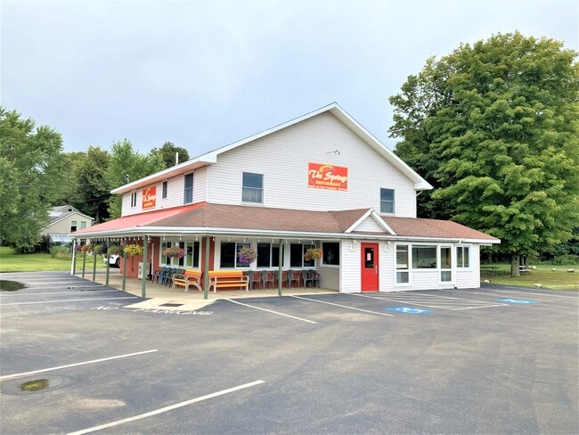
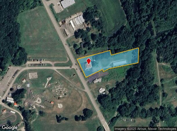
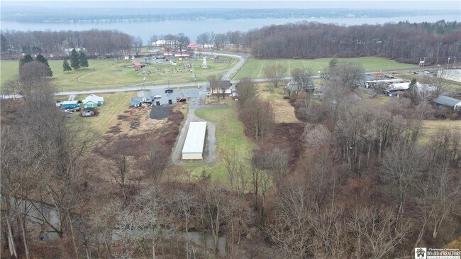
4860 Route 430
Jamestown-Dunkirk-Fredonia, NY
THE SPRINGS; OLD APN: 063689 9-1-6.2.1
063689-298-000-0001-021-000
Chautauqua
Restaurantbuilding
New York
2025
21.000
2024
2.30 AC
036901
New York West Area
3,648 SF
Other Market Areas
DEMOGRAPHICS near 4860 Route 430
1 Mile
3 Mile
5 Mile
2024 Total Population
458
3,254
6,988
2029 Population
474
3,486
7,273
Pop Growth 2024-2029
+ 3.49%
+ 7.13%
+ 4.08%
Average Age
48
50
48
2024 Total Households
206
1,510
3,164
HH Growth 2024-2029
+ 3.40%
+ 7.35%
+ 4.27%
Median Household Inc
$62,935
$46,892
$52,524
Avg Household Size
2.20
2.10
2.20
2024 Avg HH Vehicles
2.00
1.00
2.00
Median Home Value
$176,153
$284,166
$190,013
Median Year Built
1960
1968
1967
Nearby Places
Map Layers
Map Styles
 Street
 Aerial
- Restaurants
- Banks
- Shops
- Fitness
- Groceries
SALE & LEASE HISTORY
LISTING DATE
SALE/LEASE

Apr 23, 2024
For Sale
Nearby Properties
Address
Land Use
TOTAL SIZE
Lot Size
Zoning
Address
Land Use
TOTAL SIZE
Lot Size
Zoning
48,404 SF
2.20 AC
07 - MIXED
Address
Land Use
TOTAL SIZE
Lot Size
Zoning
2,128 SF
301 AC
02 - SINGL
Address
Land Use
TOTAL SIZE
Lot Size
Zoning
5,204 SF
3.70 AC
07 - MIXED
Address
Land Use
TOTAL SIZE
Lot Size
Zoning
10,660 SF
9.60 AC
07 - MIXED
Address
Land Use
TOTAL SIZE
Lot Size
Zoning
46,074 SF
17.40 AC
03 - MULTI
Address
Land Use
TOTAL SIZE
Lot Size
Zoning
6,108 SF
24.90 AC
03 - MULTI
Address
Land Use
TOTAL SIZE
Lot Size
Zoning
4,944 SF
0.44 AC
07 - MIXED
Address
Land Use
TOTAL SIZE
Lot Size
Zoning
48,217 SF
2 AC
04 - FARM
Address
Land Use
TOTAL SIZE
Lot Size
Zoning
29,157 SF
2.30 AC
07 - MIXED
Address
Land Use
TOTAL SIZE
Lot Size
Zoning
71,182 SF
1.46 AC
07 - MIXED
Address
Land Use
TOTAL SIZE
Lot Size
Zoning
46,452 SF
2.50 AC
07 - MIXED
Address
Land Use
TOTAL SIZE
Lot Size
Zoning
4,428 SF
1.80 AC
07 - MIXED
Address
Land Use
TOTAL SIZE
Lot Size
Zoning
7,788 SF
30.20 AC
02 - SINGL
Address
Land Use
TOTAL SIZE
Lot Size
Zoning
1,944 SF
1.13 AC
07 - MIXED
Address
Land Use
TOTAL SIZE
Lot Size
Zoning
156 SF
4.50 AC
07
Address
Land Use
TOTAL SIZE
Lot Size
Zoning
3,240 SF
0.92 AC
07 - MIXED
Address
Land Use
TOTAL SIZE
Lot Size
Zoning
4,311 SF
0.07 AC
07 - MIXED
Address
Land Use
TOTAL SIZE
Lot Size
Zoning
1,152 SF
4.80 AC
07 - MIXED
Address
Land Use
TOTAL SIZE
Lot Size
Zoning
9,948 SF
42.60 AC
03 - MULTI
Address
Land Use
TOTAL SIZE
Lot Size
Zoning
18,168 SF
3.80 AC
07 - MIXED
Address
Land Use
TOTAL SIZE
Lot Size
Zoning
5,000 SF
21.60 AC
05 - COMME
Address
Land Use
TOTAL SIZE
Lot Size
Zoning
4,640 SF
0.78 AC
07 - MIXED
Address
Land Use
TOTAL SIZE
Lot Size
Zoning
4,550 SF
3.90 AC
07 - MIXED
Address
Land Use
TOTAL SIZE
Lot Size
Zoning
5,668 SF
2.80 AC
07 - MIXED
Address
Land Use
TOTAL SIZE
Lot Size
Zoning
4,106 SF
123 AC
04 - FARM
Address
Land Use
TOTAL SIZE
Lot Size
Zoning
10,527 SF
1.70 AC
07 - MIXED
Address
Land Use
TOTAL SIZE
Lot Size
Zoning
8,619 SF
0.33 AC
07 - MIXED
Address
Land Use
TOTAL SIZE
Lot Size
Zoning
6,354 SF
67.50 AC
05 - COMME
Address
Land Use
TOTAL SIZE
Lot Size
Zoning
21,875 SF
14.40 AC
05 - COMME
Address
Land Use
TOTAL SIZE
Lot Size
Zoning
6,944 SF
0.94 AC
07 - MIXED
The World's #1 Commercial Real Estate Marketplace
Connect with us
© 2026 CoStar Group
The information above has been obtained from sources believed reliable. While we do not doubt its accuracy we have not verified it and make no guarantee, warranty or representation about it. It is your responsibility to independently confirm its accuracy and completeness. Any projections, opinions, assumptions, or estimates used are for example only and do not represent the current or future performance of the property. The value of this transaction to you depends on tax and other factors which should be evaluated by your tax, financial, and legal advisors. You and your advisors should conduct a careful, independent investigation of the property to determine to your satisfaction the suitability of the property for your needs.