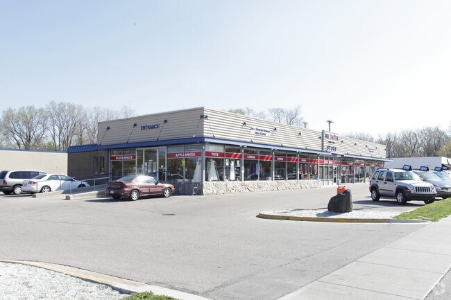
Property Record
555 28Th St Se, Grand Rapids, MI 49548
NEARBY LISTINGS FOR SALE OR LEASE
Property Detail
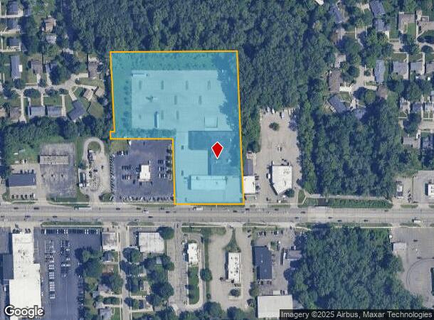
555 28Th St Se
41-18-07-453-050
411807453050 PART OF SE 1/4 COM 787.0 FT S 88D 52M 32S E ALONG S SEC LINE & 50.08 FT N 2D 08M 03S W & 250.0 FT S 88D 52M 32S
Officebuilding
Kent
X
Michigan
26081C0417D
5.80 AC
2024
S Grand Rapids/Kentwood
2025
West Michigan
004100
Grand Rapids-Wyoming, MI
32,251 SF
DEMOGRAPHICS near 555 28Th St Se
1 Mile
3 Mile
5 Mile
2024 Total Population
12,176
133,090
285,590
2029 Population
12,217
133,725
287,228
Pop Growth 2024-2029
+ 0.34%
+ 0.48%
+ 0.57%
Average Age
36
36
36
2024 Total Households
4,577
48,149
110,966
HH Growth 2024-2029
+ 0.39%
+ 0.51%
+ 0.64%
Median Household Inc
$70,906
$60,007
$61,121
Avg Household Size
2.60
2.70
2.40
2024 Avg HH Vehicles
2.00
2.00
2.00
Median Home Value
$185,436
$180,852
$199,906
Median Year Built
1950
1956
1963
Nearby Places
Map Layers
Map Styles
 Street
 Aerial
- Restaurants
- Banks
- Shops
- Fitness
- Groceries
PUBLIC TRANSPORTATION
COMMUTER RAIL
DRIVE
WALK
Distance
8 min
4.8 mi
AIRPORT
Gerald R Ford International
DRIVE
WALK
Distance
Gerald R Ford International
18 min
9.2 mi
SALE & LEASE HISTORY
LISTING DATE
SALE/LEASE

Sep 24, 2016
For Sale
Nearby Properties
Address
Land Use
TOTAL SIZE
Lot Size
Zoning
Address
Land Use
TOTAL SIZE
Lot Size
Zoning
649,177 SF
55.67 AC
SD-IT
Address
Land Use
TOTAL SIZE
Lot Size
Zoning
941,968 SF
38.56 AC
SD-IT
Address
Land Use
TOTAL SIZE
Lot Size
Zoning
194,153 SF
15.84 AC
MCN-C
Address
Land Use
TOTAL SIZE
Lot Size
Zoning
27.25 AC
SD-PRD
Address
Land Use
TOTAL SIZE
Lot Size
Zoning
1,426,319 SF
54.81 AC
SD-IT
Address
Land Use
TOTAL SIZE
Lot Size
Zoning
87.39 AC
I2
Address
Land Use
TOTAL SIZE
Lot Size
Zoning
264,739 SF
26.56 AC
I2
Address
Land Use
TOTAL SIZE
Lot Size
Zoning
13.71 AC
MCN-LDR
Address
Land Use
TOTAL SIZE
Lot Size
Zoning
146,732 SF
21.16 AC
R4
Address
Land Use
TOTAL SIZE
Lot Size
Zoning
153,571 SF
12.28 AC
SD-PRD
Address
Land Use
TOTAL SIZE
Lot Size
Zoning
536,296 SF
26.16 AC
SD-IT
Address
Land Use
TOTAL SIZE
Lot Size
Zoning
179,436 SF
24.94 AC
I2
Address
Land Use
TOTAL SIZE
Lot Size
Zoning
348,367 SF
12.15 AC
SD-IT
Address
Land Use
TOTAL SIZE
Lot Size
Zoning
29.13 AC
Address
Land Use
TOTAL SIZE
Lot Size
Zoning
162,228 SF
14.31 AC
R4
Address
Land Use
TOTAL SIZE
Lot Size
Zoning
136,112 SF
17.63 AC
MON-C
Address
Land Use
TOTAL SIZE
Lot Size
Zoning
349,885 SF
8.92 AC
I1
Address
Land Use
TOTAL SIZE
Lot Size
Zoning
174,256 SF
10.83 AC
SD-IT
Address
Land Use
TOTAL SIZE
Lot Size
Zoning
248,360 SF
7.03 AC
SD-IT
Address
Land Use
TOTAL SIZE
Lot Size
Zoning
123,517 SF
15.71 AC
MON-C
Address
Land Use
TOTAL SIZE
Lot Size
Zoning
157,386 SF
13.11 AC
R4
Address
Land Use
TOTAL SIZE
Lot Size
Zoning
442,193 SF
17.90 AC
I1
Address
Land Use
TOTAL SIZE
Lot Size
Zoning
151,032 SF
14.41 AC
MON-MDR
Address
Land Use
TOTAL SIZE
Lot Size
Zoning
260,000 SF
10.49 AC
SD-IT
Address
Land Use
TOTAL SIZE
Lot Size
Zoning
6.37 AC
MCN-MDR
Address
Land Use
TOTAL SIZE
Lot Size
Zoning
810,900 SF
44.70 AC
I2
Address
Land Use
TOTAL SIZE
Lot Size
Zoning
192,852 SF
4.27 AC
MON-MDR
Address
Land Use
TOTAL SIZE
Lot Size
Zoning
137,114 SF
12.50 AC
R4
Address
Land Use
TOTAL SIZE
Lot Size
Zoning
58,067 SF
4.15 AC
TN-LDR
Address
Land Use
TOTAL SIZE
Lot Size
Zoning
143,447 SF
10.72 AC
R4
The World's #1 Commercial Real Estate Marketplace
Connect with us
© 2025 CoStar Group
The information above has been obtained from sources believed reliable. While we do not doubt its accuracy we have not verified it and make no guarantee, warranty or representation about it. It is your responsibility to independently confirm its accuracy and completeness. Any projections, opinions, assumptions, or estimates used are for example only and do not represent the current or future performance of the property. The value of this transaction to you depends on tax and other factors which should be evaluated by your tax, financial, and legal advisors. You and your advisors should conduct a careful, independent investigation of the property to determine to your satisfaction the suitability of the property for your needs.