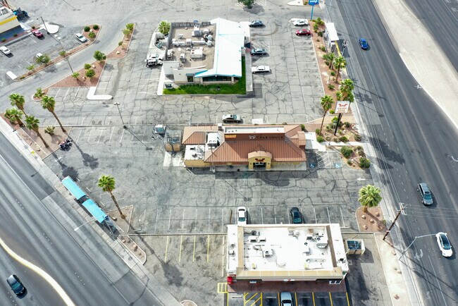
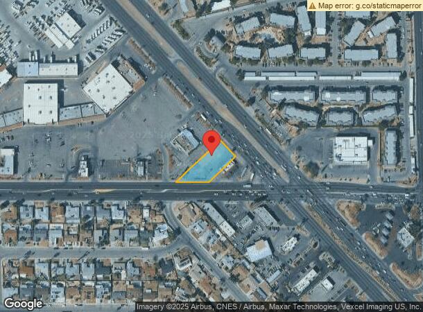
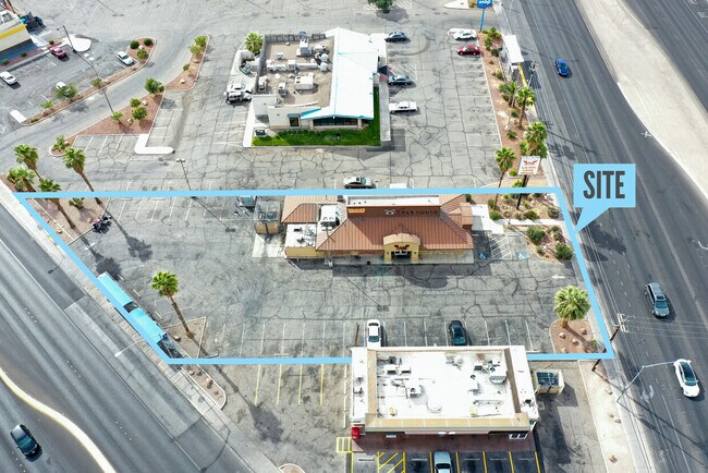
Property Record
4870 Boulder Hwy, Las Vegas, NV 89121
NEARBY LISTINGS FOR SALE OR LEASE
Property Detail
4870 Boulder Hwy
161-17-804-001
PT SE4 SE4 SEC 17-21-62
Commercialnec
Clark
X
Nevada
32003C2580F
0.52 AC
2025
East Las Vegas
2025
Las Vegas
001710
Las Vegas-Henderson-Paradise, NV
2,164 SF
DEMOGRAPHICS near 4870 Boulder Hwy
1 Mile
3 Mile
5 Mile
2024 Total Population
22,545
183,627
437,621
2029 Population
23,800
196,056
467,647
Pop Growth 2024-2029
+ 5.57%
+ 6.77%
+ 6.86%
Average Age
40
39
38
2024 Total Households
8,260
67,668
164,404
HH Growth 2024-2029
+ 5.45%
+ 6.73%
+ 6.83%
Median Household Inc
$41,924
$48,521
$46,011
Avg Household Size
2.60
2.60
2.60
2024 Avg HH Vehicles
2.00
2.00
2.00
Median Home Value
$230,874
$264,774
$284,056
Median Year Built
1978
1987
1986
Nearby Places
- Restaurants
- Banks
- Shops
- Fitness
- Groceries
PUBLIC TRANSPORTATION
AIRPORT
Harry Reid International
DRIVE
WALK
Distance
Harry Reid International
14 min
7.0 mi
Boulder City Municipal
DRIVE
WALK
Distance
Boulder City Municipal
28 min
19.3 mi
SALE & LEASE HISTORY
LISTING DATE
SALE/LEASE

May 07, 2025
For Sale
May 07, 2025
For Lease
Jan 18, 2019
For Lease
Nearby Properties
Address
Land Use
TOTAL SIZE
Lot Size
Zoning
Address
Land Use
TOTAL SIZE
Lot Size
Zoning
265,609 SF
47.36 AC
H1
Address
Land Use
TOTAL SIZE
Lot Size
Zoning
3,356 SF
336.99 AC
RE
Address
Land Use
TOTAL SIZE
Lot Size
Zoning
345,133 SF
27.01 AC
H1
Address
Land Use
TOTAL SIZE
Lot Size
Zoning
20,727 SF
319.86 AC
PF
Address
Land Use
TOTAL SIZE
Lot Size
Zoning
280 AC
PF
Address
Land Use
TOTAL SIZE
Lot Size
Zoning
410,084 SF
16.74 AC
RH24
Address
Land Use
TOTAL SIZE
Lot Size
Zoning
404,030 SF
20.17 AC
RE
Address
Land Use
TOTAL SIZE
Lot Size
Zoning
513,085 SF
53.27 AC
C2
Address
Land Use
TOTAL SIZE
Lot Size
Zoning
100.25 AC
RS1
Address
Land Use
TOTAL SIZE
Lot Size
Zoning
8,891 SF
11.59 AC
Address
Land Use
TOTAL SIZE
Lot Size
Zoning
198.15 AC
PF
Address
Land Use
TOTAL SIZE
Lot Size
Zoning
35.95 AC
PF
Address
Land Use
TOTAL SIZE
Lot Size
Zoning
38,764 SF
12.66 AC
H1
Address
Land Use
TOTAL SIZE
Lot Size
Zoning
137.65 AC
Address
Land Use
TOTAL SIZE
Lot Size
Zoning
38.36 AC
Address
Land Use
TOTAL SIZE
Lot Size
Zoning
4,460 SF
27.52 AC
Address
Land Use
TOTAL SIZE
Lot Size
Zoning
15.95 AC
PF
Address
Land Use
TOTAL SIZE
Lot Size
Zoning
35.42 AC
PS
Address
Land Use
TOTAL SIZE
Lot Size
Zoning
4.93 AC
Address
Land Use
TOTAL SIZE
Lot Size
Zoning
43.37 AC
RS1
Address
Land Use
TOTAL SIZE
Lot Size
Zoning
6,659 SF
6.05 AC
H1
Address
Land Use
TOTAL SIZE
Lot Size
Zoning
7,908 SF
24.13 AC
R4
Address
Land Use
TOTAL SIZE
Lot Size
Zoning
4.18 AC
PF
Address
Land Use
TOTAL SIZE
Lot Size
Zoning
82,405 SF
5.49 AC
PS
Address
Land Use
TOTAL SIZE
Lot Size
Zoning
7,304 SF
12.58 AC
R4
Address
Land Use
TOTAL SIZE
Lot Size
Zoning
3,424 SF
14.53 AC
R3
Address
Land Use
TOTAL SIZE
Lot Size
Zoning
6,117 SF
14.90 AC
PF
Address
Land Use
TOTAL SIZE
Lot Size
Zoning
40.07 AC
PF
Address
Land Use
TOTAL SIZE
Lot Size
Zoning
3,865 SF
13 AC
R3
Address
Land Use
TOTAL SIZE
Lot Size
Zoning
3,596 SF
8.50 AC
The World's #1 Commercial Real Estate Marketplace
Connect with us
© 2025 CoStar Group
The information above has been obtained from sources believed reliable. While we do not doubt its accuracy we have not verified it and make no guarantee, warranty or representation about it. It is your responsibility to independently confirm its accuracy and completeness. Any projections, opinions, assumptions, or estimates used are for example only and do not represent the current or future performance of the property. The value of this transaction to you depends on tax and other factors which should be evaluated by your tax, financial, and legal advisors. You and your advisors should conduct a careful, independent investigation of the property to determine to your satisfaction the suitability of the property for your needs.