Property Record
4871 Petaluma Blvd S, Petaluma, CA 94952
NEARBY LISTINGS FOR SALE OR LEASE
-
-
View all Petaluma listings for sale on LoopNet.com
Property Detail
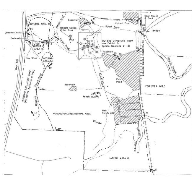
4871 Petaluma Blvd S
019-340-001
C/E OR 97034017
Dairyfarm
Sonoma
AE
California
06041C0154E
394.74 AC
2024
Petaluma/Cotati/Rohnert
2025
North Bay/Santa Rosa
151000
Santa Rosa, CA
18,422 SF
DEMOGRAPHICS near 4871 Petaluma Blvd S
1 Mile
3 Mile
5 Mile
2024 Total Population
86
28,902
61,006
2029 Population
86
28,523
60,195
Pop Growth 2024-2029
0.00%
(1.31%)
(1.33%)
Average Age
43
43
43
2024 Total Households
34
11,020
23,731
HH Growth 2024-2029
0.00%
(1.32%)
(1.32%)
Median Household Inc
$145,833
$112,626
$110,110
Avg Household Size
2.50
2.60
2.50
2024 Avg HH Vehicles
2.00
2.00
2.00
Median Home Value
$1,027,273
$786,409
$781,744
Median Year Built
1997
1975
1979
Nearby Places
Map Layers
Map Styles
 Street
 Aerial
- Restaurants
- Banks
- Shops
- Fitness
- Groceries
PUBLIC TRANSPORTATION
COMMUTER RAIL
Petaluma Downtown Smart (Main Line - Sonoma Marin Area Rail Transit)
DRIVE
WALK
Distance
Petaluma Downtown Smart (Main Line - Sonoma Marin Area Rail Transit)
5 min
3.8 mi
Smart Petaluma North (Main Line - Sonoma Marin Area Rail Transit)
DRIVE
WALK
Distance
Smart Petaluma North (Main Line - Sonoma Marin Area Rail Transit)
9 min
5.9 mi
AIRPORT
Charles M Schulz - Sonoma County
DRIVE
WALK
Distance
Charles M Schulz - Sonoma County
33 min
26.9 mi
Freight Ports
Port of Richmond
DRIVE
WALK
Distance
Port of Richmond
44 min
32.1 mi
Nearby Properties
Address
Land Use
TOTAL SIZE
Lot Size
Zoning
Address
Land Use
TOTAL SIZE
Lot Size
Zoning
458,444 SF
32.23 AC
CITYPE
Address
Land Use
TOTAL SIZE
Lot Size
Zoning
0.76 AC
ML
Address
Land Use
TOTAL SIZE
Lot Size
Zoning
5.03 AC
CITYPE
Address
Land Use
TOTAL SIZE
Lot Size
Zoning
40,925 SF
11.06 AC
CITYPE
Address
Land Use
TOTAL SIZE
Lot Size
Zoning
134,732 SF
2.05 AC
Address
Land Use
TOTAL SIZE
Lot Size
Zoning
5.89 AC
PCD
Address
Land Use
TOTAL SIZE
Lot Size
Zoning
98,382 SF
6.83 AC
SP
Address
Land Use
TOTAL SIZE
Lot Size
Zoning
120,480 SF
6.87 AC
CITYPE
Address
Land Use
TOTAL SIZE
Lot Size
Zoning
145,152 SF
8.39 AC
Address
Land Use
TOTAL SIZE
Lot Size
Zoning
109,993 SF
2.31 AC
Address
Land Use
TOTAL SIZE
Lot Size
Zoning
165,000 SF
9.99 AC
Address
Land Use
TOTAL SIZE
Lot Size
Zoning
0.96 AC
MG
Address
Land Use
TOTAL SIZE
Lot Size
Zoning
10,000 SF
16.50 AC
Address
Land Use
TOTAL SIZE
Lot Size
Zoning
94,000 SF
4.87 AC
Address
Land Use
TOTAL SIZE
Lot Size
Zoning
15,722 SF
193.04 AC
Address
Land Use
TOTAL SIZE
Lot Size
Zoning
185,841 SF
11.05 AC
ML
Address
Land Use
TOTAL SIZE
Lot Size
Zoning
135,105 SF
7.54 AC
Address
Land Use
TOTAL SIZE
Lot Size
Zoning
42,102 SF
136.77 AC
Address
Land Use
TOTAL SIZE
Lot Size
Zoning
80,000 SF
3.73 AC
Address
Land Use
TOTAL SIZE
Lot Size
Zoning
49,549 SF
4.02 AC
CITYPE
Address
Land Use
TOTAL SIZE
Lot Size
Zoning
62,565 SF
4.55 AC
Address
Land Use
TOTAL SIZE
Lot Size
Zoning
85,354 SF
3.61 AC
Address
Land Use
TOTAL SIZE
Lot Size
Zoning
98,997 SF
1.90 AC
M1B8FRZN
Address
Land Use
TOTAL SIZE
Lot Size
Zoning
123,503 SF
5.72 AC
Address
Land Use
TOTAL SIZE
Lot Size
Zoning
5.78 AC
CITYPE
Address
Land Use
TOTAL SIZE
Lot Size
Zoning
71,808 SF
1.56 AC
Address
Land Use
TOTAL SIZE
Lot Size
Zoning
75,773 SF
4.47 AC
Address
Land Use
TOTAL SIZE
Lot Size
Zoning
67,462 SF
5.32 AC
Address
Land Use
TOTAL SIZE
Lot Size
Zoning
22,724 SF
3.12 AC
ML
Address
Land Use
TOTAL SIZE
Lot Size
Zoning
75,245 SF
4.74 AC
PCD
The World's #1 Commercial Real Estate Marketplace
Connect with us
© 2025 CoStar Group
The information above has been obtained from sources believed reliable. While we do not doubt its accuracy we have not verified it and make no guarantee, warranty or representation about it. It is your responsibility to independently confirm its accuracy and completeness. Any projections, opinions, assumptions, or estimates used are for example only and do not represent the current or future performance of the property. The value of this transaction to you depends on tax and other factors which should be evaluated by your tax, financial, and legal advisors. You and your advisors should conduct a careful, independent investigation of the property to determine to your satisfaction the suitability of the property for your needs.