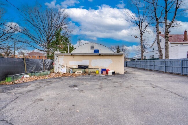
Property Record
4873 Broadview Rd, Cleveland, OH 44109


NEARBY LISTINGS FOR SALE OR LEASE
-
-
-
-
-
No Photo
-
-
-
View all Cleveland listings for sale on LoopNet.com
Property Detail
4873 Broadview Rd
Cleveland-Elyria, OH
Cooksub
010-10-003
78 COOKSUB 0003 ALL
Commercialnec
Cuyahoga
X
Ohio
39035C0187E
3
2024
0.18 AC
2024
South
106900
Cleveland
1,967 SF
DEMOGRAPHICS near 4873 Broadview Rd
1 mile
3 mile
5 mile
2024 Total Population
17,717
103,681
277,923
2029 Population
17,115
100,042
269,009
Pop Growth 2024-2029
(3.40%)
(3.51%)
(3.21%)
Average Age
41
40
40
2024 Total Households
7,915
44,740
119,917
HH Growth 2024-2029
(3.64%)
(3.73%)
(3.35%)
Median Household Inc
$52,759
$51,901
$47,835
Avg Household Size
2.10
2.20
2.20
2024 Avg HH Vehicles
2.00
2.00
2.00
Median Home Value
$123,728
$129,696
$131,823
Median Year Built
1949
1951
1951
Nearby Places
Map Layers
Map Styles
 Street
 Aerial
Transit
 Traffic
 Biking
Places
Listings with unknown addresses are not visible on the map
- Restaurants
- Banks
- Shops
- Fitness
- Groceries
PUBLIC TRANSPORTATION
COMMUTER RAIL
Drive
Walk
Distance
11 min
5.4 mi
Drive
Walk
Distance
14 min
7.1 mi
AIRPORT
Cleveland-Hopkins International
Drive
Walk
Distance
Cleveland-Hopkins International
18 min
9.5 mi
SALE & LEASE HISTORY
LISTING DATE
SALE/LEASE

Mar 20, 2025
For Sale
Nearby Properties
Address
Land Use
TOTAL SIZE
Lot Size
Zoning
Address
Land Use
TOTAL SIZE
Lot Size
Zoning
3,491,901 SF
34.32 AC
Address
Land Use
TOTAL SIZE
Lot Size
Zoning
162,711 SF
192.04 AC
IG
Address
Land Use
TOTAL SIZE
Lot Size
Zoning
257,857 SF
8.03 AC
GR
Address
Land Use
TOTAL SIZE
Lot Size
Zoning
436,164 SF
20.01 AC
U-5
Address
Land Use
TOTAL SIZE
Lot Size
Zoning
384,714 SF
4.75 AC
U-5-HR
Address
Land Use
TOTAL SIZE
Lot Size
Zoning
194,257 SF
94.46 AC
IG
Address
Land Use
TOTAL SIZE
Lot Size
Zoning
102,219 SF
14.01 AC
RB
Address
Land Use
TOTAL SIZE
Lot Size
Zoning
228,134 SF
40.65 AC
UI
Address
Land Use
TOTAL SIZE
Lot Size
Zoning
475,286 SF
5.81 AC
U-5-HR
Address
Land Use
TOTAL SIZE
Lot Size
Zoning
46,250 SF
16.36 AC
U-5
Address
Land Use
TOTAL SIZE
Lot Size
Zoning
239,000 SF
6.29 AC
U-6A
Address
Land Use
TOTAL SIZE
Lot Size
Zoning
372,486 SF
3.98 AC
GR
Address
Land Use
TOTAL SIZE
Lot Size
Zoning
361,287 SF
86.50 AC
2F
Address
Land Use
TOTAL SIZE
Lot Size
Zoning
225,593 SF
4.79 AC
U-6A
Address
Land Use
TOTAL SIZE
Lot Size
Zoning
78,622 SF
11.78 AC
CB
Address
Land Use
TOTAL SIZE
Lot Size
Zoning
389,067 SF
12.05 AC
A-H
Address
Land Use
TOTAL SIZE
Lot Size
Zoning
168,322 SF
14.44 AC
Address
Land Use
TOTAL SIZE
Lot Size
Zoning
500,398 SF
24.49 AC
IG
Address
Land Use
TOTAL SIZE
Lot Size
Zoning
137,178 SF
8.62 AC
Address
Land Use
TOTAL SIZE
Lot Size
Zoning
440,765 SF
44.35 AC
2F
Address
Land Use
TOTAL SIZE
Lot Size
Zoning
180,175 SF
111.96 AC
IG
Address
Land Use
TOTAL SIZE
Lot Size
Zoning
209,068 SF
23.10 AC
IG
Address
Land Use
TOTAL SIZE
Lot Size
Zoning
277,049 SF
24.15 AC
2F
Address
Land Use
TOTAL SIZE
Lot Size
Zoning
19.48 AC
U5-A
Address
Land Use
TOTAL SIZE
Lot Size
Zoning
87,489 SF
8.01 AC
Address
Land Use
TOTAL SIZE
Lot Size
Zoning
372,022 SF
7.54 AC
Address
Land Use
TOTAL SIZE
Lot Size
Zoning
16,023 SF
18.41 AC
SF-DH
Address
Land Use
TOTAL SIZE
Lot Size
Zoning
239,222 SF
22.87 AC
G-B
Address
Land Use
TOTAL SIZE
Lot Size
Zoning
208,675 SF
17.33 AC
G-B
Address
Land Use
TOTAL SIZE
Lot Size
Zoning
116,373 SF
13.28 AC
U-3
The World's #1 Commercial Real Estate Marketplace
Connect with us
© 2026 CoStar Group
The information above has been obtained from sources believed reliable. While we do not doubt its accuracy we have not verified it and make no guarantee, warranty or representation about it. It is your responsibility to independently confirm its accuracy and completeness. Any projections, opinions, assumptions, or estimates used are for example only and do not represent the current or future performance of the property. The value of this transaction to you depends on tax and other factors which should be evaluated by your tax, financial, and legal advisors. You and your advisors should conduct a careful, independent investigation of the property to determine to your satisfaction the suitability of the property for your needs.