Property Record
4873 State Route 5, Vernon, NY 13476


NEARBY LISTINGS FOR SALE OR LEASE
-
-
View all Vernon listings for sale on LoopNet.com
Property Detail
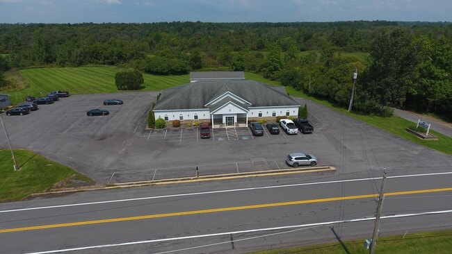
4873 State Route 5
306089 323.000-1-13.1
Oneida
Professionalbldglegalinsurancerealestateetc
New York
X
13.001
36065C0679F
2.98 AC
2025
Outlying Oneida County
2024
Utica/Rome
024900
Utica-Rome, NY
6,000 SF
DEMOGRAPHICS near 4873 State Route 5
1 Mile
3 Mile
5 Mile
2024 Total Population
293
6,116
18,468
2029 Population
277
5,908
17,899
Pop Growth 2024-2029
(5.46%)
(3.40%)
(3.08%)
Average Age
43
44
43
2024 Total Households
123
2,635
7,949
HH Growth 2024-2029
(5.69%)
(3.57%)
(3.25%)
Median Household Inc
$77,174
$76,765
$63,116
Avg Household Size
2.40
2.30
2.30
2024 Avg HH Vehicles
2.00
2.00
2.00
Median Home Value
$151,249
$171,789
$159,667
Median Year Built
1952
1951
1953
Nearby Places
Map Layers
Map Styles
 Street
 Aerial
- Restaurants
- Banks
- Shops
- Fitness
- Groceries
PUBLIC TRANSPORTATION
AIRPORT
Syracuse Hancock International
DRIVE
WALK
Distance
Syracuse Hancock International
52 min
36.9 mi
Freight Ports
Albany, NY Port
DRIVE
WALK
Distance
Albany, NY Port
141 min
116.1 mi
SALE & LEASE HISTORY
LISTING DATE
SALE/LEASE

Aug 28, 2024
For Sale
Nearby Properties
Address
Land Use
TOTAL SIZE
Lot Size
Zoning
Address
Land Use
TOTAL SIZE
Lot Size
Zoning
179,325 SF
131.08 AC
01 - NOT Z
Address
Land Use
TOTAL SIZE
Lot Size
Zoning
6,000 SF
123.32 AC
Address
Land Use
TOTAL SIZE
Lot Size
Zoning
1.24 AC
01
Address
Land Use
TOTAL SIZE
Lot Size
Zoning
133,580 SF
01 - NOT Z
Address
Land Use
TOTAL SIZE
Lot Size
Zoning
21,150 SF
3.74 AC
Address
Land Use
TOTAL SIZE
Lot Size
Zoning
32,956 SF
23.95 AC
01 - NOT Z
Address
Land Use
TOTAL SIZE
Lot Size
Zoning
159.97 AC
Address
Land Use
TOTAL SIZE
Lot Size
Zoning
42,454 SF
12.07 AC
01 - NOT Z
Address
Land Use
TOTAL SIZE
Lot Size
Zoning
205,242 SF
34.07 AC
Address
Land Use
TOTAL SIZE
Lot Size
Zoning
205,242 SF
46.75 AC
Address
Land Use
TOTAL SIZE
Lot Size
Zoning
205,242 SF
46.75 AC
Address
Land Use
TOTAL SIZE
Lot Size
Zoning
53.30 AC
Address
Land Use
TOTAL SIZE
Lot Size
Zoning
33,675 SF
6.50 AC
01 - NOT Z
Address
Land Use
TOTAL SIZE
Lot Size
Zoning
33,675 SF
6.50 AC
01 - NOT Z
Address
Land Use
TOTAL SIZE
Lot Size
Zoning
48.42 AC
Address
Land Use
TOTAL SIZE
Lot Size
Zoning
246,600 SF
48.42 AC
01 - NOT Z
Address
Land Use
TOTAL SIZE
Lot Size
Zoning
31,877 SF
1.56 AC
01 - NOT Z
Address
Land Use
TOTAL SIZE
Lot Size
Zoning
15,752 SF
9.12 AC
Address
Land Use
TOTAL SIZE
Lot Size
Zoning
15,752 SF
9.12 AC
Address
Land Use
TOTAL SIZE
Lot Size
Zoning
6,000 SF
1.94 AC
01 - NOT Z
Address
Land Use
TOTAL SIZE
Lot Size
Zoning
6,000 SF
1.94 AC
Address
Land Use
TOTAL SIZE
Lot Size
Zoning
38.70 AC
01 - NOT Z
Address
Land Use
TOTAL SIZE
Lot Size
Zoning
21,150 SF
3.74 AC
Address
Land Use
TOTAL SIZE
Lot Size
Zoning
31,850 SF
3.40 AC
01 - NOT Z
Address
Land Use
TOTAL SIZE
Lot Size
Zoning
31,850 SF
3.40 AC
01 - NOT Z
Address
Land Use
TOTAL SIZE
Lot Size
Zoning
31,850 SF
3.40 AC
01 - NOT Z
Address
Land Use
TOTAL SIZE
Lot Size
Zoning
81,228 SF
19.48 AC
01 - NOT Z
Address
Land Use
TOTAL SIZE
Lot Size
Zoning
40,312 SF
1 AC
01 - NOT Z
Address
Land Use
TOTAL SIZE
Lot Size
Zoning
64,216 SF
8.05 AC
R1
Address
Land Use
TOTAL SIZE
Lot Size
Zoning
5,024 SF
2.65 AC
01 - NOT Z
The World's #1 Commercial Real Estate Marketplace
Connect with us
© 2025 CoStar Group
The information above has been obtained from sources believed reliable. While we do not doubt its accuracy we have not verified it and make no guarantee, warranty or representation about it. It is your responsibility to independently confirm its accuracy and completeness. Any projections, opinions, assumptions, or estimates used are for example only and do not represent the current or future performance of the property. The value of this transaction to you depends on tax and other factors which should be evaluated by your tax, financial, and legal advisors. You and your advisors should conduct a careful, independent investigation of the property to determine to your satisfaction the suitability of the property for your needs.