Property Record
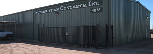
4878 S Delaware Dr, Apache Junction, AZ 85120


Property Detail
4878 S Delaware Dr
104-63-008X
COMM @ CNTR 1/4 COR OF SEC 6-1S-8E TH S-489.88 TH W-40 TO POB TH S-170.80 TH W-290.10 TH N-170.22 TH E-290.10 TO POB 1.13 AC
Warehouse
Pinal
CI2
Arizona
B and X Area of moderate flood hazard, usually the area between the limits of the 100-year and 500-year floods.
1.13 AC
2024
Pinal County
2025
Phoenix
000319
Phoenix-Mesa-Chandler, AZ
7,674 SF
NEARBY LISTINGS FOR SALE OR LEASE
DEMOGRAPHICS near 4878 S Delaware Dr
1 mile
3 mile
5 mile
2025 Total Population
3,113
62,740
177,183
2030 Population
3,553
68,384
193,028
Pop Growth 2025-2030
+ 14.13%
+ 9.00%
+ 8.94%
Average Age
62
44
43
2025 Total Households
1,577
23,962
68,893
HH Growth 2025-2030
+ 13.76%
+ 9.84%
+ 9.60%
Median Household Inc
$68,039
$84,378
$79,690
Avg Household Size
2.00
2.50
2.50
2025 Avg HH Vehicles
1.00
2.00
2.00
Median Home Value
$399,249
$413,523
$391,417
Median Year Built
2001
2001
2000
Nearby Places
Map Layers
Map Styles
 Street
 Aerial
Transit
 Traffic
 Biking
Places
Listings with unknown addresses are not visible on the map
- Restaurants
- Banks
- Shops
- Fitness
- Groceries
PUBLIC TRANSPORTATION
AIRPORT
Phoenix-Mesa Gateway
Drive
Walk
Distance
Phoenix-Mesa Gateway
26 min
12.9 mi
Phoenix Sky Harbor International
Drive
Walk
Distance
Phoenix Sky Harbor International
44 min
31.7 mi
Nearby Properties
Address
Land Use
TOTAL SIZE
Lot Size
Zoning
Address
Land Use
TOTAL SIZE
Lot Size
Zoning
493,357 SF
46.94 AC
C-N
Address
Land Use
TOTAL SIZE
Lot Size
Zoning
108,297 SF
102.46 AC
PS
Address
Land Use
TOTAL SIZE
Lot Size
Zoning
Address
Land Use
TOTAL SIZE
Lot Size
Zoning
128,905 SF
7.14 AC
UNDESIGNAT
Address
Land Use
TOTAL SIZE
Lot Size
Zoning
Address
Land Use
TOTAL SIZE
Lot Size
Zoning
Address
Land Use
TOTAL SIZE
Lot Size
Zoning
209,737 SF
21.98 AC
UNDESIGNAT
Address
Land Use
TOTAL SIZE
Lot Size
Zoning
1,355,382 SF
83.17 AC
PAD
Address
Land Use
TOTAL SIZE
Lot Size
Zoning
467,727 SF
104.86 AC
AG
Address
Land Use
TOTAL SIZE
Lot Size
Zoning
454,704 SF
101.68 AC
AG
Address
Land Use
TOTAL SIZE
Lot Size
Zoning
126,549 SF
9.75 AC
Address
Land Use
TOTAL SIZE
Lot Size
Zoning
52,961 SF
7.94 AC
Address
Land Use
TOTAL SIZE
Lot Size
Zoning
54,706 SF
16.20 AC
UNDESIGNAT
Address
Land Use
TOTAL SIZE
Lot Size
Zoning
779,546 SF
53.20 AC
LI
Address
Land Use
TOTAL SIZE
Lot Size
Zoning
422,427 SF
18.21 AC
C-C
Address
Land Use
TOTAL SIZE
Lot Size
Zoning
Address
Land Use
TOTAL SIZE
Lot Size
Zoning
173,840 SF
6 AC
UNDESIGNAT
Address
Land Use
TOTAL SIZE
Lot Size
Zoning
965,386 SF
60.57 AC
Address
Land Use
TOTAL SIZE
Lot Size
Zoning
38,353 SF
5 AC
Address
Land Use
TOTAL SIZE
Lot Size
Zoning
4.77 AC
LC
Address
Land Use
TOTAL SIZE
Lot Size
Zoning
30,775 SF
7.60 AC
UNDESIGNAT
Address
Land Use
TOTAL SIZE
Lot Size
Zoning
345,968 SF
14.65 AC
RM4
Address
Land Use
TOTAL SIZE
Lot Size
Zoning
102,430 SF
5 AC
UNDESIGNAT
Address
Land Use
TOTAL SIZE
Lot Size
Zoning
27,121 SF
4.05 AC
Address
Land Use
TOTAL SIZE
Lot Size
Zoning
196,400 SF
15.67 AC
Address
Land Use
TOTAL SIZE
Lot Size
Zoning
961,432 SF
63.41 AC
Address
Land Use
TOTAL SIZE
Lot Size
Zoning
13.52 AC
Address
Land Use
TOTAL SIZE
Lot Size
Zoning
62,758 SF
5 AC
UNDESIGNAT
Address
Land Use
TOTAL SIZE
Lot Size
Zoning
4,000 SF
20 AC
CI2
The World's #1 Commercial Real Estate Marketplace
Connect with us
© 2026 CoStar Group
The information above has been obtained from sources believed reliable. While we do not doubt its accuracy we have not verified it and make no guarantee, warranty or representation about it. It is your responsibility to independently confirm its accuracy and completeness. Any projections, opinions, assumptions, or estimates used are for example only and do not represent the current or future performance of the property. The value of this transaction to you depends on tax and other factors which should be evaluated by your tax, financial, and legal advisors. You and your advisors should conduct a careful, independent investigation of the property to determine to your satisfaction the suitability of the property for your needs.