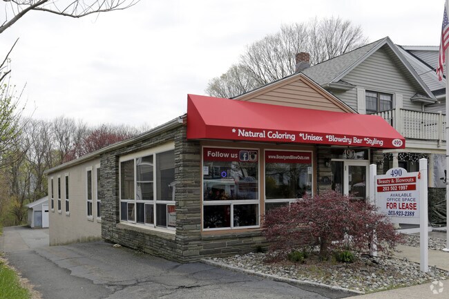
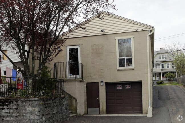
Property Record
491 Huntington Rd, Stratford, CT 06614

NEARBY LISTINGS FOR SALE OR LEASE
Property Detail
491 Huntington Rd
Bridgeport-Stamford-Norwalk, CT
Fairfield
STRA-004013-000024-000008
Connecticut
Triplex
0.13 AC
X
Stratford
09001C0434G
Westchester/So Connecticut
2,740 SF
DEMOGRAPHICS near 491 Huntington Rd
1 Mile
3 Mile
5 Mile
2024 Total Population
15,247
105,582
242,709
2029 Population
15,215
105,696
243,123
Pop Growth 2024-2029
(0.21%)
+ 0.11%
+ 0.17%
Average Age
41
41
40
2024 Total Households
5,575
40,440
91,238
HH Growth 2024-2029
(0.32%)
+ 0.17%
+ 0.18%
Median Household Inc
$104,920
$72,702
$68,423
Avg Household Size
2.70
2.50
2.50
2024 Avg HH Vehicles
2.00
2.00
2.00
Median Home Value
$289,209
$273,917
$288,125
Median Year Built
1952
1954
1956
Nearby Places
Map Layers
Map Styles
 Street
 Aerial
- Restaurants
- Banks
- Shops
- Fitness
- Groceries
PUBLIC TRANSPORTATION
COMMUTER RAIL
Stratford Station (New Haven Line - Metro-North Commuter Railroad Company (Metro-North))
DRIVE
WALK
Distance
Stratford Station (New Haven Line - Metro-North Commuter Railroad Company (Metro-North))
3 min
1.4 mi
Milford Station (New Haven Line - Metro-North Commuter Railroad Company (Metro-North))
DRIVE
WALK
Distance
Milford Station (New Haven Line - Metro-North Commuter Railroad Company (Metro-North))
10 min
5.7 mi
AIRPORT
Tweed/New Haven
DRIVE
WALK
Distance
Tweed/New Haven
32 min
19.7 mi
Long Island MacArthur
DRIVE
WALK
Distance
Long Island MacArthur
117 min
39.7 mi
Westchester County
DRIVE
WALK
Distance
Westchester County
58 min
40.3 mi
SALE & LEASE HISTORY
LISTING DATE
SALE/LEASE

May 09, 2017
For Lease
Nearby Properties
Address
Land Use
TOTAL SIZE
Lot Size
Zoning
Address
Land Use
TOTAL SIZE
Lot Size
Zoning
8.24 AC
Address
Land Use
TOTAL SIZE
Lot Size
Zoning
145,000 SF
15.70 AC
ILI
Address
Land Use
TOTAL SIZE
Lot Size
Zoning
4.14 AC
MUEM
Address
Land Use
TOTAL SIZE
Lot Size
Zoning
28.30 AC
HDD
Address
Land Use
TOTAL SIZE
Lot Size
Zoning
23 AC
RC
Address
Land Use
TOTAL SIZE
Lot Size
Zoning
23.70 AC
RB
Address
Land Use
TOTAL SIZE
Lot Size
Zoning
104,284 SF
13.36 AC
CDD5
Address
Land Use
TOTAL SIZE
Lot Size
Zoning
31.70 AC
R30
Address
Land Use
TOTAL SIZE
Lot Size
Zoning
177,799 SF
27.55 AC
RS-3
Address
Land Use
TOTAL SIZE
Lot Size
Zoning
110,506 SF
0.06 AC
RBB
Address
Land Use
TOTAL SIZE
Lot Size
Zoning
745,516 SF
32.74 AC
HDD
Address
Land Use
TOTAL SIZE
Lot Size
Zoning
56,762 SF
13.34 AC
BZZ
Address
Land Use
TOTAL SIZE
Lot Size
Zoning
722 SF
47.10 AC
RM-1
Address
Land Use
TOTAL SIZE
Lot Size
Zoning
630 SF
107.70 AC
RA
Address
Land Use
TOTAL SIZE
Lot Size
Zoning
265,059 SF
47.61 AC
F-17
Address
Land Use
TOTAL SIZE
Lot Size
Zoning
90 AC
RA
Address
Land Use
TOTAL SIZE
Lot Size
Zoning
8.27 AC
C
Address
Land Use
TOTAL SIZE
Lot Size
Zoning
160,957 SF
26.40 AC
R12.
Address
Land Use
TOTAL SIZE
Lot Size
Zoning
226,848 SF
14.23 AC
BC
Address
Land Use
TOTAL SIZE
Lot Size
Zoning
2,966 SF
12.27 AC
E-6
Address
Land Use
TOTAL SIZE
Lot Size
Zoning
89,760 SF
18.58 AC
RM-1
Address
Land Use
TOTAL SIZE
Lot Size
Zoning
128,236 SF
2.88 AC
E-13
Address
Land Use
TOTAL SIZE
Lot Size
Zoning
33.57 AC
RC
Address
Land Use
TOTAL SIZE
Lot Size
Zoning
121,332 SF
19.59 AC
F-12
Address
Land Use
TOTAL SIZE
Lot Size
Zoning
7.30 AC
R-1
Address
Land Use
TOTAL SIZE
Lot Size
Zoning
13.90 AC
IL2
Address
Land Use
TOTAL SIZE
Lot Size
Zoning
9.12 AC
R12.
Address
Land Use
TOTAL SIZE
Lot Size
Zoning
178,466 SF
5.90 AC
RS-4
Address
Land Use
TOTAL SIZE
Lot Size
Zoning
12.09 AC
RC
Address
Land Use
TOTAL SIZE
Lot Size
Zoning
176,748 SF
44.64 AC
E-8
The World's #1 Commercial Real Estate Marketplace
Connect with us
© 2026 CoStar Group
The information above has been obtained from sources believed reliable. While we do not doubt its accuracy we have not verified it and make no guarantee, warranty or representation about it. It is your responsibility to independently confirm its accuracy and completeness. Any projections, opinions, assumptions, or estimates used are for example only and do not represent the current or future performance of the property. The value of this transaction to you depends on tax and other factors which should be evaluated by your tax, financial, and legal advisors. You and your advisors should conduct a careful, independent investigation of the property to determine to your satisfaction the suitability of the property for your needs.