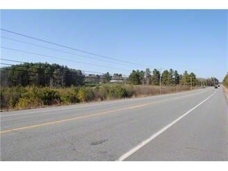
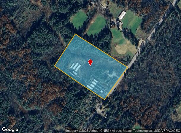
Property Record
488 Narragansett Trl, Buxton, ME 04093
NEARBY LISTINGS FOR SALE OR LEASE
Property Detail
488 Narragansett Trl
Commercialnec
York
X
Maine
23031C0282G
10.77 AC
2024
York County
2024
Portland/South Portland
020001
Portland-South Portland, ME
896 SF
BUXT-000006-000000-000044A
DEMOGRAPHICS near 488 Narragansett Trl
1 Mile
3 Mile
5 Mile
2024 Total Population
545
5,011
14,373
2029 Population
560
5,181
14,868
Pop Growth 2024-2029
+ 2.75%
+ 3.39%
+ 3.44%
Average Age
45
43
42
2024 Total Households
218
1,944
5,340
HH Growth 2024-2029
+ 2.75%
+ 3.24%
+ 3.33%
Median Household Inc
$73,772
$83,035
$89,404
Avg Household Size
2.40
2.50
2.60
2024 Avg HH Vehicles
2.00
2.00
2.00
Median Home Value
$321,014
$320,414
$333,202
Median Year Built
1977
1980
1984
Nearby Places
Map Layers
Map Styles
 Street
 Aerial
- Restaurants
- Banks
- Shops
- Fitness
- Groceries
PUBLIC TRANSPORTATION
AIRPORT
Portland International Jetport
DRIVE
WALK
Distance
Portland International Jetport
24 min
12.0 mi
Freight Ports
Portland, ME
DRIVE
WALK
Distance
Portland, ME
29 min
15.7 mi
Nearby Properties
Address
Land Use
TOTAL SIZE
Lot Size
Zoning
Address
Land Use
TOTAL SIZE
Lot Size
Zoning
9,152 SF
39.96 AC
BUXTON
Address
Land Use
TOTAL SIZE
Lot Size
Zoning
35,441 SF
12 AC
BUXTON
Address
Land Use
TOTAL SIZE
Lot Size
Zoning
10,704 SF
196 AC
BUXTON
Address
Land Use
TOTAL SIZE
Lot Size
Zoning
15,930 SF
8.26 AC
BUXTON
Address
Land Use
TOTAL SIZE
Lot Size
Zoning
8,800 SF
2.97 AC
BUXTON
Address
Land Use
TOTAL SIZE
Lot Size
Zoning
3,640 SF
14.21 AC
16
Address
Land Use
TOTAL SIZE
Lot Size
Zoning
1,200 SF
2.20 AC
BUXTON
Address
Land Use
TOTAL SIZE
Lot Size
Zoning
2,400 SF
2.60 AC
BUXTON
Address
Land Use
TOTAL SIZE
Lot Size
Zoning
4,216 SF
3.13 AC
BUXTON
Address
Land Use
TOTAL SIZE
Lot Size
Zoning
5,250 SF
1.84 AC
BUXTON
Address
Land Use
TOTAL SIZE
Lot Size
Zoning
10,000 SF
1.60 AC
BUXTON
Address
Land Use
TOTAL SIZE
Lot Size
Zoning
64.99 AC
RR3
Address
Land Use
TOTAL SIZE
Lot Size
Zoning
2,470 SF
10.69 AC
BUXTON
Address
Land Use
TOTAL SIZE
Lot Size
Zoning
3,200 SF
5.30 AC
BUXTON
Address
Land Use
TOTAL SIZE
Lot Size
Zoning
1,680 SF
3.25 AC
BUXTON
Address
Land Use
TOTAL SIZE
Lot Size
Zoning
3,780 SF
0.89 AC
BUXTON
Address
Land Use
TOTAL SIZE
Lot Size
Zoning
6.68 AC
RR3 ED
Address
Land Use
TOTAL SIZE
Lot Size
Zoning
12,350 SF
2.44 AC
BUXTON
Address
Land Use
TOTAL SIZE
Lot Size
Zoning
600 SF
4.62 AC
BUXTON
Address
Land Use
TOTAL SIZE
Lot Size
Zoning
1,080 SF
3.10 AC
BUXTON
Address
Land Use
TOTAL SIZE
Lot Size
Zoning
560 SF
2.35 AC
BUXTON
Address
Land Use
TOTAL SIZE
Lot Size
Zoning
2,264 SF
32.10 AC
16
Address
Land Use
TOTAL SIZE
Lot Size
Zoning
1,600 SF
5 AC
BUXTON
Address
Land Use
TOTAL SIZE
Lot Size
Zoning
3,264 SF
32 AC
BUXTON
Address
Land Use
TOTAL SIZE
Lot Size
Zoning
4,818 SF
2 AC
BUXTON
Address
Land Use
TOTAL SIZE
Lot Size
Zoning
3,356 SF
2 AC
BUXTON
Address
Land Use
TOTAL SIZE
Lot Size
Zoning
63.50 AC
BUXTON
Address
Land Use
TOTAL SIZE
Lot Size
Zoning
4,064 SF
2.90 AC
BUXTON
Address
Land Use
TOTAL SIZE
Lot Size
Zoning
540 SF
1.88 AC
C-1
The World's #1 Commercial Real Estate Marketplace
Connect with us
© 2026 CoStar Group
The information above has been obtained from sources believed reliable. While we do not doubt its accuracy we have not verified it and make no guarantee, warranty or representation about it. It is your responsibility to independently confirm its accuracy and completeness. Any projections, opinions, assumptions, or estimates used are for example only and do not represent the current or future performance of the property. The value of this transaction to you depends on tax and other factors which should be evaluated by your tax, financial, and legal advisors. You and your advisors should conduct a careful, independent investigation of the property to determine to your satisfaction the suitability of the property for your needs.