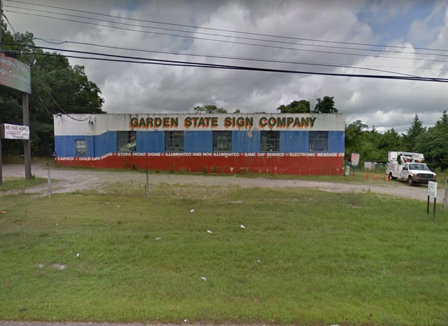
Property Record
4880 Us Highway 9, Howell, NJ 07731
NEARBY LISTINGS FOR SALE OR LEASE
Property Detail
4880 Us Highway 9
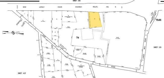
21-00074-0000-00008
Monmouth
Warehouse
New Jersey
X
8
34025C0313F
1.32 AC
2024
Western Monmouth
2025
Northern New Jersey
811304
New York-Jersey City-White Plains, NY-NJ
4,000 SF
DEMOGRAPHICS near 4880 Us Highway 9
1 Mile
3 Mile
5 Mile
2024 Total Population
4,866
80,351
171,866
2029 Population
4,761
81,880
176,075
Pop Growth 2024-2029
(2.16%)
+ 1.90%
+ 2.45%
Average Age
41
30
30
2024 Total Households
1,656
20,209
43,591
HH Growth 2024-2029
(2.60%)
+ 0.86%
+ 1.46%
Median Household Inc
$122,979
$85,675
$83,662
Avg Household Size
2.80
3.60
3.60
2024 Avg HH Vehicles
2.00
2.00
2.00
Median Home Value
$371,309
$399,729
$399,486
Median Year Built
1980
1981
1986
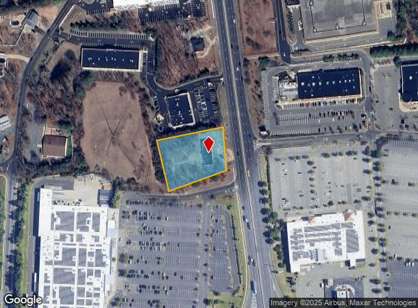
Nearby Places
Map Layers
Map Styles
 Street
 Aerial
- Restaurants
- Banks
- Shops
- Fitness
- Groceries
SALE & LEASE HISTORY
LISTING DATE
SALE/LEASE

Mar 06, 2019
For Sale
Feb 11, 2020
For Sale
Nearby Properties
Address
Land Use
TOTAL SIZE
Lot Size
Zoning
Address
Land Use
TOTAL SIZE
Lot Size
Zoning
113.02 AC
R12
Address
Land Use
TOTAL SIZE
Lot Size
Zoning
24.15 AC
MF
Address
Land Use
TOTAL SIZE
Lot Size
Zoning
36,678 SF
38.75 AC
MFAH
Address
Land Use
TOTAL SIZE
Lot Size
Zoning
105.04 AC
SED
Address
Land Use
TOTAL SIZE
Lot Size
Zoning
161,340 SF
35.35 AC
HD-1
Address
Land Use
TOTAL SIZE
Lot Size
Zoning
237,479 SF
21 AC
LC
Address
Land Use
TOTAL SIZE
Lot Size
Zoning
21,876 SF
22.26 AC
B3
Address
Land Use
TOTAL SIZE
Lot Size
Zoning
14.90 AC
PFE
Address
Land Use
TOTAL SIZE
Lot Size
Zoning
1,032 SF
12.50 AC
HC
Address
Land Use
TOTAL SIZE
Lot Size
Zoning
36.25 AC
R12
Address
Land Use
TOTAL SIZE
Lot Size
Zoning
87,347 SF
10.18 AC
HC
Address
Land Use
TOTAL SIZE
Lot Size
Zoning
18.34 AC
HC
Address
Land Use
TOTAL SIZE
Lot Size
Zoning
28.99 AC
HD-1
Address
Land Use
TOTAL SIZE
Lot Size
Zoning
14.73 AC
R-5
Address
Land Use
TOTAL SIZE
Lot Size
Zoning
37,202 SF
14.79 AC
B3
Address
Land Use
TOTAL SIZE
Lot Size
Zoning
8,784 SF
16.16 AC
R-LM
Address
Land Use
TOTAL SIZE
Lot Size
Zoning
1,825 SF
49.38 AC
OSP
Address
Land Use
TOTAL SIZE
Lot Size
Zoning
8.43 AC
MF
Address
Land Use
TOTAL SIZE
Lot Size
Zoning
17.08 AC
R15
Address
Land Use
TOTAL SIZE
Lot Size
Zoning
1,270 SF
3.65 AC
R12
Address
Land Use
TOTAL SIZE
Lot Size
Zoning
360,400 SF
35.98 AC
SED
Address
Land Use
TOTAL SIZE
Lot Size
Zoning
112 SF
20.47 AC
HCMF
Address
Land Use
TOTAL SIZE
Lot Size
Zoning
127,932 SF
2.41 AC
R-OP
Address
Land Use
TOTAL SIZE
Lot Size
Zoning
3.64 AC
R10
Address
Land Use
TOTAL SIZE
Lot Size
Zoning
96,503 SF
2.26 AC
R-OP
Address
Land Use
TOTAL SIZE
Lot Size
Zoning
26,473 SF
0.72 AC
R-OP
Address
Land Use
TOTAL SIZE
Lot Size
Zoning
98,731 SF
13.65 AC
HD
Address
Land Use
TOTAL SIZE
Lot Size
Zoning
3.39 AC
HC
Address
Land Use
TOTAL SIZE
Lot Size
Zoning
6,210 SF
5 AC
HC
Address
Land Use
TOTAL SIZE
Lot Size
Zoning
83,396 SF
9.51 AC
R15
The World's #1 Commercial Real Estate Marketplace
Connect with us
© 2025 CoStar Group
The information above has been obtained from sources believed reliable. While we do not doubt its accuracy we have not verified it and make no guarantee, warranty or representation about it. It is your responsibility to independently confirm its accuracy and completeness. Any projections, opinions, assumptions, or estimates used are for example only and do not represent the current or future performance of the property. The value of this transaction to you depends on tax and other factors which should be evaluated by your tax, financial, and legal advisors. You and your advisors should conduct a careful, independent investigation of the property to determine to your satisfaction the suitability of the property for your needs.