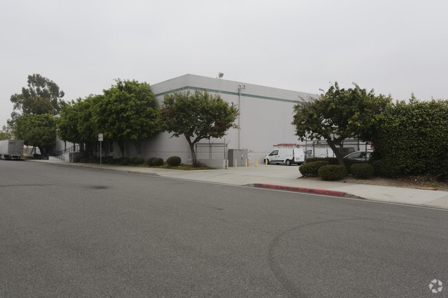
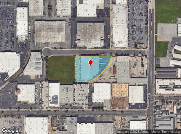
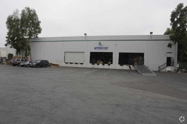
Property Record
4882 W 145Th St, Hawthorne, CA 90250

Current Lease Availabilities
NEARBY LISTINGS FOR SALE OR LEASE
Property Detail
4882 W 145Th St
Los Angeles-Long Beach-Glendale, CA
Redondo Land Co
4149-001-095
*TR=PARCEL MAP AS PER BK 78 PG 20 OF P M LOT 6
Warehouse
Los Angeles
X
California
06037C1790F
6
2024
2.01 AC
2025
Gardena/Hawthorne
602301
Los Angeles
46,813 SF
DEMOGRAPHICS near 4882 W 145Th St
1 Mile
3 Mile
5 Mile
2024 Total Population
27,188
283,467
583,159
2029 Population
26,203
275,166
566,345
Pop Growth 2024-2029
(3.62%)
(2.93%)
(2.88%)
Average Age
39
39
40
2024 Total Households
8,926
98,332
207,851
HH Growth 2024-2029
(3.92%)
(3.11%)
(3.04%)
Median Household Inc
$90,712
$90,982
$86,276
Avg Household Size
3.00
2.80
2.70
2024 Avg HH Vehicles
2.00
2.00
2.00
Median Home Value
$767,238
$912,558
$861,765
Median Year Built
1959
1964
1963
Nearby Places
- Restaurants
- Banks
- Shops
- Fitness
- Groceries
PUBLIC TRANSPORTATION
TRANSIT/SUBWAY
Marine/Redondo Station (Green Line - Los Angeles County Metropolitan Transportation Authority (Metro))
DRIVE
WALK
Distance
Marine/Redondo Station (Green Line - Los Angeles County Metropolitan Transportation Authority (Metro))
2 min
18 min
0.9 mi
AIRPORT
Los Angeles International
DRIVE
WALK
Distance
Los Angeles International
12 min
6.3 mi
Long Beach (Daugherty Field)
DRIVE
WALK
Distance
Long Beach (Daugherty Field)
21 min
14.8 mi
Bob Hope
DRIVE
WALK
Distance
Bob Hope
41 min
30.0 mi
Freight Ports
Port of Long Beach
DRIVE
WALK
Distance
Port of Long Beach
24 min
16.7 mi
Nearby Properties
Address
Land Use
TOTAL SIZE
Lot Size
Zoning
Address
Land Use
TOTAL SIZE
Lot Size
Zoning
1,807,845 SF
7.28 AC
ESC3
Address
Land Use
TOTAL SIZE
Lot Size
Zoning
584,746 SF
20.38 AC
MNIP
Address
Land Use
TOTAL SIZE
Lot Size
Zoning
1,315,931 SF
3.36 AC
ESC3
Address
Land Use
TOTAL SIZE
Lot Size
Zoning
565,264 SF
5.95 AC
Address
Land Use
TOTAL SIZE
Lot Size
Zoning
337,106 SF
9.56 AC
ESCM*
Address
Land Use
TOTAL SIZE
Lot Size
Zoning
944,791 SF
22.53 AC
ESCM*
Address
Land Use
TOTAL SIZE
Lot Size
Zoning
421,934 SF
8.24 AC
ESCM
Address
Land Use
TOTAL SIZE
Lot Size
Zoning
459,058 SF
8.84 AC
ESC3*
Address
Land Use
TOTAL SIZE
Lot Size
Zoning
553,161 SF
21.61 AC
ESM2*
Address
Land Use
TOTAL SIZE
Lot Size
Zoning
718,086 SF
41.24 AC
RBI-1A
Address
Land Use
TOTAL SIZE
Lot Size
Zoning
418,131 SF
3.03 AC
LCC1
Address
Land Use
TOTAL SIZE
Lot Size
Zoning
793,455 SF
31.88 AC
ESM2*
Address
Land Use
TOTAL SIZE
Lot Size
Zoning
848,217 SF
36.09 AC
RBI-1A
Address
Land Use
TOTAL SIZE
Lot Size
Zoning
1,410,144 SF
6.35 AC
ESM2*
Address
Land Use
TOTAL SIZE
Lot Size
Zoning
189,244 SF
3.64 AC
ESCM*
Address
Land Use
TOTAL SIZE
Lot Size
Zoning
319,589 SF
5.13 AC
MNPD
Address
Land Use
TOTAL SIZE
Lot Size
Zoning
876,121 SF
9.03 AC
ESC3
Address
Land Use
TOTAL SIZE
Lot Size
Zoning
1,972,924 SF
ESCM*
Address
Land Use
TOTAL SIZE
Lot Size
Zoning
448,818 SF
2.69 AC
ESC3*
Address
Land Use
TOTAL SIZE
Lot Size
Zoning
120,484 SF
11.63 AC
ESM2*
Address
Land Use
TOTAL SIZE
Lot Size
Zoning
307,559 SF
5.96 AC
ESC3
Address
Land Use
TOTAL SIZE
Lot Size
Zoning
195,493 SF
2.91 AC
ESC3*
Address
Land Use
TOTAL SIZE
Lot Size
Zoning
279,694 SF
3.19 AC
LCR1*
Address
Land Use
TOTAL SIZE
Lot Size
Zoning
1,504,661 SF
RBCR
Address
Land Use
TOTAL SIZE
Lot Size
Zoning
543,897 SF
4.26 AC
ESC3*
Address
Land Use
TOTAL SIZE
Lot Size
Zoning
1,009,919 SF
8.80 AC
ESM1*
Address
Land Use
TOTAL SIZE
Lot Size
Zoning
354,673 SF
4.99 AC
ESCM*
Address
Land Use
TOTAL SIZE
Lot Size
Zoning
561,479 SF
4.44 AC
ESC3*
Address
Land Use
TOTAL SIZE
Lot Size
Zoning
362,343 SF
9.16 AC
ESM2*
The World's #1 Commercial Real Estate Marketplace
Connect with us
© 2025 CoStar Group
The information above has been obtained from sources believed reliable. While we do not doubt its accuracy we have not verified it and make no guarantee, warranty or representation about it. It is your responsibility to independently confirm its accuracy and completeness. Any projections, opinions, assumptions, or estimates used are for example only and do not represent the current or future performance of the property. The value of this transaction to you depends on tax and other factors which should be evaluated by your tax, financial, and legal advisors. You and your advisors should conduct a careful, independent investigation of the property to determine to your satisfaction the suitability of the property for your needs.