Property Record
4885 E 86Th St N, Sperry, OK 74073

Save to a Folder
{{folder.Name}}
{{folder.ListingIds.length}} Properties
{{folder.ListingIds.length}} Property
Create a New Folder
Property Detail
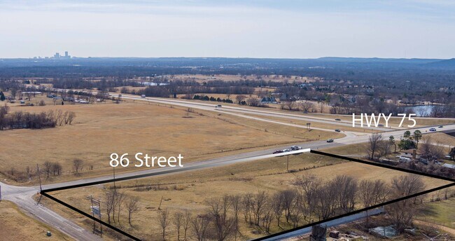
4885 E 86Th St N
91321-13-21-63770
TR IN E/2 SE BEG 50N SECR SE TH WLY138.67 NWLY305.94 WLY199.05 N239.10 E640.87 S283.73 POB SEC 21 21 13 3.817ACS
Publicstorage
TULSA
CS
Oklahoma
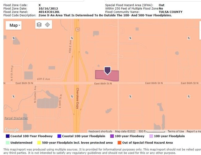
B and X Area of moderate flood hazard, usually the area between the limits of the 100-year and 500-year floods.
3.71 AC
2025
Northeast
2025
Tulsa
005808
Tulsa, OK
8,000 SF
NEARBY LISTINGS FOR SALE OR LEASE
DEMOGRAPHICS near 4885 E 86Th St N
1 mile
3 mile
5 mile
2025 Total Population
429
5,822
39,900
2030 Population
457
6,148
41,552
Pop Growth 2025-2030
+ 6.53%
+ 5.60%
+ 4.14%
Average Age
41
40
38
2025 Total Households
153
2,112
14,862
HH Growth 2025-2030
+ 6.54%
+ 5.68%
+ 4.14%
Median Household Inc
$110,625
$101,550
$66,556
Avg Household Size
2.70
2.70
2.60
2025 Avg HH Vehicles
2.00
2.00
2.00
Median Home Value
$433,928
$382,133
$235,446
Median Year Built
2010
2009
1988
Nearby Places
Map Layers
Map Styles
 Street
 Aerial
Layers
 Traffic
 Biking
Places
Listings with unknown addresses are not visible on the map
- Restaurants
- Banks
- Shops
- Fitness
- Groceries
PUBLIC TRANSPORTATION
AIRPORT
Tulsa International
Drive
Walk
Distance
Tulsa International
16 min
9.7 mi
SALE & LEASE HISTORY
LISTING DATE
SALE/LEASE

Jul 19, 2022
For Sale
Nearby Properties
Address
Land Use
TOTAL SIZE
Lot Size
Zoning
Address
Land Use
TOTAL SIZE
Lot Size
Zoning
3,235,512 SF
71.56 AC
IM
Address
Land Use
TOTAL SIZE
Lot Size
Zoning
873,896 SF
50 AC
IM
Address
Land Use
TOTAL SIZE
Lot Size
Zoning
209,620 SF
19.59 AC
IM
Address
Land Use
TOTAL SIZE
Lot Size
Zoning
429,912 SF
59.57 AC
IM
Address
Land Use
TOTAL SIZE
Lot Size
Zoning
65,354 SF
41.54 AC
AG
Address
Land Use
TOTAL SIZE
Lot Size
Zoning
63,108 SF
33.82 AC
AG
Address
Land Use
TOTAL SIZE
Lot Size
Zoning
457,823 SF
25.72 AC
IM
Address
Land Use
TOTAL SIZE
Lot Size
Zoning
67,909 SF
48.73 AC
IM
Address
Land Use
TOTAL SIZE
Lot Size
Zoning
16,196 SF
9.73 AC
IL
Address
Land Use
TOTAL SIZE
Lot Size
Zoning
266,778 SF
12.26 AC
CN
Address
Land Use
TOTAL SIZE
Lot Size
Zoning
859,108 SF
86.24 AC
IM
Address
Land Use
TOTAL SIZE
Lot Size
Zoning
27,314 SF
12.29 AC
AG
Address
Land Use
TOTAL SIZE
Lot Size
Zoning
229,485 SF
16.77 AC
IM
Address
Land Use
TOTAL SIZE
Lot Size
Zoning
32,300 SF
20.88 AC
NCU
Address
Land Use
TOTAL SIZE
Lot Size
Zoning
133,467 SF
11.37 AC
CS
Address
Land Use
TOTAL SIZE
Lot Size
Zoning
473,599 SF
56.42 AC
IM
Address
Land Use
TOTAL SIZE
Lot Size
Zoning
419,821 SF
38.38 AC
IM
Address
Land Use
TOTAL SIZE
Lot Size
Zoning
113.74 AC
AG
Address
Land Use
TOTAL SIZE
Lot Size
Zoning
9,566 SF
8.26 AC
IL
Address
Land Use
TOTAL SIZE
Lot Size
Zoning
137,320 SF
40.12 AC
IM
Address
Land Use
TOTAL SIZE
Lot Size
Zoning
83,000 SF
10.51 AC
IM
Address
Land Use
TOTAL SIZE
Lot Size
Zoning
175,614 SF
33.58 AC
IM
Address
Land Use
TOTAL SIZE
Lot Size
Zoning
14,836 SF
9.39 AC
AGR
Address
Land Use
TOTAL SIZE
Lot Size
Zoning
85,489 SF
17.99 AC
IM
Address
Land Use
TOTAL SIZE
Lot Size
Zoning
13.64 AC
O
Address
Land Use
TOTAL SIZE
Lot Size
Zoning
1,200 SF
38.79 AC
AG
Address
Land Use
TOTAL SIZE
Lot Size
Zoning
136,660 SF
29.88 AC
IM
Address
Land Use
TOTAL SIZE
Lot Size
Zoning
108,900 SF
9.84 AC
IM
Address
Land Use
TOTAL SIZE
Lot Size
Zoning
7,129 SF
4.15 AC
IM
Address
Land Use
TOTAL SIZE
Lot Size
Zoning
80,894 SF
5.19 AC
IM
The World's #1 Commercial Real Estate Marketplace
Connect with us
© 2026 CoStar Group
The information above has been obtained from sources believed reliable. While we do not doubt its accuracy we have not verified it and make no guarantee, warranty or representation about it. It is your responsibility to independently confirm its accuracy and completeness. Any projections, opinions, assumptions, or estimates used are for example only and do not represent the current or future performance of the property. The value of this transaction to you depends on tax and other factors which should be evaluated by your tax, financial, and legal advisors. You and your advisors should conduct a careful, independent investigation of the property to determine to your satisfaction the suitability of the property for your needs.