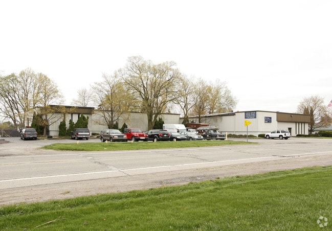
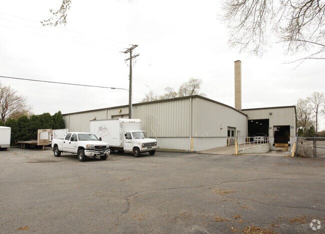
Property Record
489 E Huron River Dr, Belleville, MI 48111
NEARBY LISTINGS FOR SALE OR LEASE
Property Detail
489 E Huron River Dr
Detroit-Warren-Dearborn, MI
Huron Park No 1
31-087-01-0375-000
22A375 TO 378 LOTS 375 TO 378 INCL HURON PARK NO. 1 SUB T3S R8E L56 P14 WCR
Warehouse
Wayne
X
Michigan
26163C0353E
375-378
2025
0.35 AC
2025
Airport District
587000
Detroit
18,658 SF
DEMOGRAPHICS near 489 E Huron River Dr
1 Mile
3 Mile
5 Mile
2024 Total Population
5,210
27,755
63,220
2029 Population
5,032
26,585
61,586
Pop Growth 2024-2029
(3.42%)
(4.22%)
(2.58%)
Average Age
43
41
41
2024 Total Households
2,353
12,199
26,814
HH Growth 2024-2029
(3.36%)
(4.21%)
(2.64%)
Median Household Inc
$61,716
$67,335
$67,727
Avg Household Size
2.20
2.20
2.30
2024 Avg HH Vehicles
2.00
2.00
2.00
Median Home Value
$238,820
$233,237
$213,944
Median Year Built
1976
1978
1981
Nearby Places
Map Layers
Map Styles
 Street
 Aerial
- Restaurants
- Banks
- Shops
- Fitness
- Groceries
PUBLIC TRANSPORTATION
AIRPORT
Detroit Metro Wayne County
DRIVE
WALK
Distance
Detroit Metro Wayne County
16 min
8.9 mi
Windsor International
DRIVE
WALK
Distance
Windsor International
57 min
37.5 mi
Freight Ports
Port of Toledo
DRIVE
WALK
Distance
Port of Toledo
66 min
51.8 mi
Nearby Properties
Address
Land Use
TOTAL SIZE
Lot Size
Zoning
Address
Land Use
TOTAL SIZE
Lot Size
Zoning
461,566 SF
50.13 AC
RM MULT
Address
Land Use
TOTAL SIZE
Lot Size
Zoning
495,062 SF
52.40 AC
M1 LIG
Address
Land Use
TOTAL SIZE
Lot Size
Zoning
357,286 SF
36.79 AC
RM MULT
Address
Land Use
TOTAL SIZE
Lot Size
Zoning
432.42 AC
M2 GEN
Address
Land Use
TOTAL SIZE
Lot Size
Zoning
1,071,200 SF
85.27 AC
M1 LIG
Address
Land Use
TOTAL SIZE
Lot Size
Zoning
206,958 SF
8.33 AC
AP
Address
Land Use
TOTAL SIZE
Lot Size
Zoning
198,549 SF
13.43 AC
RM MULT
Address
Land Use
TOTAL SIZE
Lot Size
Zoning
630,828 SF
62.51 AC
R1B
Address
Land Use
TOTAL SIZE
Lot Size
Zoning
196,044 SF
18.67 AC
RM MULT
Address
Land Use
TOTAL SIZE
Lot Size
Zoning
437,836 SF
28.75 AC
M1 LIG
Address
Land Use
TOTAL SIZE
Lot Size
Zoning
161,794 SF
17.73 AC
RM MULT
Address
Land Use
TOTAL SIZE
Lot Size
Zoning
132,528 SF
5.91 AC
C2 EXT
Address
Land Use
TOTAL SIZE
Lot Size
Zoning
25,002 SF
7.91 AC
C1 GEN
Address
Land Use
TOTAL SIZE
Lot Size
Zoning
199,776 SF
39.34 AC
C2 EXT
Address
Land Use
TOTAL SIZE
Lot Size
Zoning
137,893 SF
16.21 AC
C2 EXT
Address
Land Use
TOTAL SIZE
Lot Size
Zoning
191,446 SF
22.76 AC
C2 EXT
Address
Land Use
TOTAL SIZE
Lot Size
Zoning
198,304 SF
23.96 AC
C2 EXT
Address
Land Use
TOTAL SIZE
Lot Size
Zoning
3,184 SF
41.02 AC
Address
Land Use
TOTAL SIZE
Lot Size
Zoning
76,763 SF
9.63 AC
M1 LIG
Address
Land Use
TOTAL SIZE
Lot Size
Zoning
119,319 SF
10.23 AC
RM MULT
Address
Land Use
TOTAL SIZE
Lot Size
Zoning
62,633 SF
6.39 AC
C LOC
Address
Land Use
TOTAL SIZE
Lot Size
Zoning
69,415 SF
11.32 AC
C2 EXT
Address
Land Use
TOTAL SIZE
Lot Size
Zoning
282,628 SF
22.93 AC
M1 LIG
Address
Land Use
TOTAL SIZE
Lot Size
Zoning
102,395 SF
11 AC
RM MULT
Address
Land Use
TOTAL SIZE
Lot Size
Zoning
140,677 SF
11.19 AC
RM MULT
Address
Land Use
TOTAL SIZE
Lot Size
Zoning
158,744 SF
10.17 AC
RM MULT
Address
Land Use
TOTAL SIZE
Lot Size
Zoning
500 SF
37.70 AC
Address
Land Use
TOTAL SIZE
Lot Size
Zoning
86,611 SF
15.38 AC
C2 EXT
Address
Land Use
TOTAL SIZE
Lot Size
Zoning
62,729 SF
20.01 AC
C2 EXT
Address
Land Use
TOTAL SIZE
Lot Size
Zoning
174,163 SF
17.87 AC
M1 LIG
The World's #1 Commercial Real Estate Marketplace
Connect with us
© 2026 CoStar Group
The information above has been obtained from sources believed reliable. While we do not doubt its accuracy we have not verified it and make no guarantee, warranty or representation about it. It is your responsibility to independently confirm its accuracy and completeness. Any projections, opinions, assumptions, or estimates used are for example only and do not represent the current or future performance of the property. The value of this transaction to you depends on tax and other factors which should be evaluated by your tax, financial, and legal advisors. You and your advisors should conduct a careful, independent investigation of the property to determine to your satisfaction the suitability of the property for your needs.