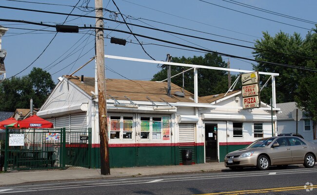
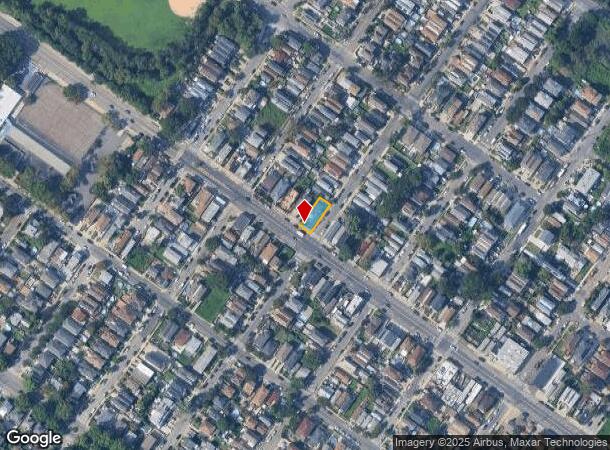
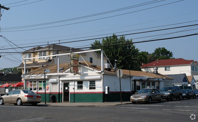
Property Record
489 Midland Ave, Staten Island, NY 10306
NEARBY LISTINGS FOR SALE OR LEASE
Property Detail
489 Midland Ave
03735-0001
Staten Island
Storebuilding
New York
AE
1
3604970328F
0.09 AC
2024
Staten Island
2025
Long Island (New York)
011203
New York-Jersey City-White Plains, NY-NJ
2,395 SF
DEMOGRAPHICS near 489 Midland Ave
1 Mile
3 Mile
5 Mile
2024 Total Population
30,112
160,815
450,076
2029 Population
29,860
159,314
441,649
Pop Growth 2024-2029
(0.84%)
(0.93%)
(1.87%)
Average Age
42
42
41
2024 Total Households
10,573
55,904
161,105
HH Growth 2024-2029
(0.92%)
(1.00%)
(2.03%)
Median Household Inc
$83,796
$84,732
$86,748
Avg Household Size
2.80
2.80
2.70
2024 Avg HH Vehicles
1.00
1.00
1.00
Median Home Value
$650,692
$674,283
$661,676
Median Year Built
1969
1971
1967
Nearby Places
- Restaurants
- Banks
- Shops
- Fitness
- Groceries
PUBLIC TRANSPORTATION
TRANSIT/SUBWAY
Grant City (Staten Island Railway - New York MTA Subway (The Subway))
DRIVE
WALK
Distance
Grant City (Staten Island Railway - New York MTA Subway (The Subway))
4 min
17 min
0.9 mi
Jefferson Avenue (Staten Island Railway - New York MTA Subway (The Subway))
DRIVE
WALK
Distance
Jefferson Avenue (Staten Island Railway - New York MTA Subway (The Subway))
4 min
20 min
1.0 mi
COMMUTER RAIL
Grant City (Staten Island Railway - New York MTA Subway (The Subway))
DRIVE
WALK
Distance
Grant City (Staten Island Railway - New York MTA Subway (The Subway))
3 min
17 min
0.9 mi
Jefferson Avenue (Staten Island Railway - New York MTA Subway (The Subway))
DRIVE
WALK
Distance
Jefferson Avenue (Staten Island Railway - New York MTA Subway (The Subway))
4 min
20 min
1.0 mi
AIRPORT
Newark Liberty International
DRIVE
WALK
Distance
Newark Liberty International
32 min
19.0 mi
LaGuardia
DRIVE
WALK
Distance
LaGuardia
40 min
22.8 mi
John F Kennedy International
DRIVE
WALK
Distance
John F Kennedy International
39 min
25.5 mi
Freight Ports
New York Container Terminal
DRIVE
WALK
Distance
New York Container Terminal
18 min
9.8 mi
Nearby Properties
Address
Land Use
TOTAL SIZE
Lot Size
Zoning
Address
Land Use
TOTAL SIZE
Lot Size
Zoning
3,600 SF
731.18 AC
PARK
Address
Land Use
TOTAL SIZE
Lot Size
Zoning
686,130 SF
189.62 AC
R3-2
Address
Land Use
TOTAL SIZE
Lot Size
Zoning
640,077 SF
19.34 AC
R3-1
Address
Land Use
TOTAL SIZE
Lot Size
Zoning
566,000 SF
103.31 AC
R3-2
Address
Land Use
TOTAL SIZE
Lot Size
Zoning
135,000 SF
117.71 AC
PARK
Address
Land Use
TOTAL SIZE
Lot Size
Zoning
236,591 SF
207.66 AC
R3-2
Address
Land Use
TOTAL SIZE
Lot Size
Zoning
310,560 SF
15.90 AC
C4-1
Address
Land Use
TOTAL SIZE
Lot Size
Zoning
494,840 SF
34.77 AC
R3-2
Address
Land Use
TOTAL SIZE
Lot Size
Zoning
521,405 SF
52.79 AC
R3-1
Address
Land Use
TOTAL SIZE
Lot Size
Zoning
421,275 SF
18.95 AC
R3-2
Address
Land Use
TOTAL SIZE
Lot Size
Zoning
111,000 SF
186.03 AC
PARK
Address
Land Use
TOTAL SIZE
Lot Size
Zoning
294,320 SF
15 AC
R3-2
Address
Land Use
TOTAL SIZE
Lot Size
Zoning
240 SF
47.41 AC
R3-2
Address
Land Use
TOTAL SIZE
Lot Size
Zoning
476,145 SF
50.97 AC
R3-1
Address
Land Use
TOTAL SIZE
Lot Size
Zoning
48,500 SF
61.98 AC
R3-2
Address
Land Use
TOTAL SIZE
Lot Size
Zoning
77,502 SF
1.29 AC
R3-1
Address
Land Use
TOTAL SIZE
Lot Size
Zoning
900 SF
50 AC
R1-1
Address
Land Use
TOTAL SIZE
Lot Size
Zoning
151,637 SF
7.41 AC
C4-1
Address
Land Use
TOTAL SIZE
Lot Size
Zoning
45,570 SF
206.38 AC
PARKUS
Address
Land Use
TOTAL SIZE
Lot Size
Zoning
26.45 AC
PARK
Address
Land Use
TOTAL SIZE
Lot Size
Zoning
7,410 SF
44.60 AC
R1-1
Address
Land Use
TOTAL SIZE
Lot Size
Zoning
151,080 SF
17.59 AC
R1-2
Address
Land Use
TOTAL SIZE
Lot Size
Zoning
37.30 AC
PARK
Address
Land Use
TOTAL SIZE
Lot Size
Zoning
180,000 SF
2.28 AC
R2
Address
Land Use
TOTAL SIZE
Lot Size
Zoning
146,568 SF
26.40 AC
R3-1
Address
Land Use
TOTAL SIZE
Lot Size
Zoning
12,400 SF
47.97 AC
R3-2
Address
Land Use
TOTAL SIZE
Lot Size
Zoning
3,000 SF
40 AC
R3-2
Address
Land Use
TOTAL SIZE
Lot Size
Zoning
15,110 SF
245.56 AC
PARK
Address
Land Use
TOTAL SIZE
Lot Size
Zoning
2,750 SF
53.95 AC
R3-2
Address
Land Use
TOTAL SIZE
Lot Size
Zoning
142,888 SF
3.12 AC
R3-1
The World's #1 Commercial Real Estate Marketplace
Connect with us
© 2025 CoStar Group
The information above has been obtained from sources believed reliable. While we do not doubt its accuracy we have not verified it and make no guarantee, warranty or representation about it. It is your responsibility to independently confirm its accuracy and completeness. Any projections, opinions, assumptions, or estimates used are for example only and do not represent the current or future performance of the property. The value of this transaction to you depends on tax and other factors which should be evaluated by your tax, financial, and legal advisors. You and your advisors should conduct a careful, independent investigation of the property to determine to your satisfaction the suitability of the property for your needs.