Property Record
489 Old Ithaca Rd, Horseheads, NY 14845
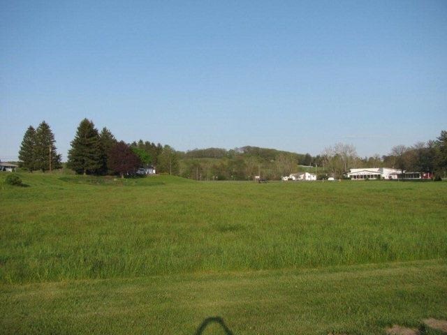
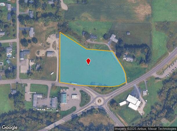
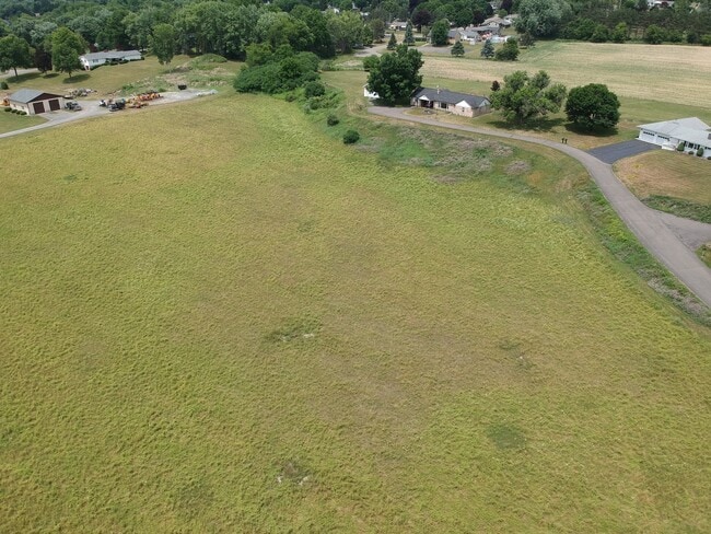
This Property Is For Sale
NEARBY LISTINGS FOR SALE OR LEASE
-
-
View all Horseheads listings for sale on LoopNet.com
Property Detail
489 Old Ithaca Rd
Elmira, NY
Chemung
073489-049-002-0004-024-000-0000
New York
Commercialacreage
24.000
2025
5.43 AC
2024
Ithaca/Elmira
010400
Other Market Areas
DEMOGRAPHICS near 489 Old Ithaca Rd
1 Mile
3 Mile
5 Mile
2024 Total Population
1,925
11,045
23,297
2029 Population
1,865
10,687
22,500
Pop Growth 2024-2029
(3.12%)
(3.24%)
(3.42%)
Average Age
43
44
44
2024 Total Households
795
4,918
10,158
HH Growth 2024-2029
(3.14%)
(3.25%)
(3.47%)
Median Household Inc
$68,896
$61,946
$64,240
Avg Household Size
2.40
2.20
2.20
2024 Avg HH Vehicles
2.00
2.00
2.00
Median Home Value
$176,729
$152,684
$155,832
Median Year Built
1972
1966
1964
Nearby Places
Map Layers
Map Styles
 Street
 Aerial
- Restaurants
- Banks
- Shops
- Fitness
- Groceries
PUBLIC TRANSPORTATION
AIRPORT
Elmira/Corning Regional
DRIVE
WALK
Distance
Elmira/Corning Regional
14 min
9.7 mi
Ithaca Tompkins International
DRIVE
WALK
Distance
Ithaca Tompkins International
43 min
30.5 mi
Freight Ports
Albany, NY Port
DRIVE
WALK
Distance
Albany, NY Port
240 min
200.9 mi
Nearby Properties
Address
Land Use
TOTAL SIZE
Lot Size
Zoning
Address
Land Use
TOTAL SIZE
Lot Size
Zoning
2,199 SF
89.38 AC
02 - SINGL
Address
Land Use
TOTAL SIZE
Lot Size
Zoning
464,844 SF
180.98 AC
VH08
Address
Land Use
TOTAL SIZE
Lot Size
Zoning
150,280 SF
14.32 AC
VH08
Address
Land Use
TOTAL SIZE
Lot Size
Zoning
9,600 SF
87 AC
VH08
Address
Land Use
TOTAL SIZE
Lot Size
Zoning
55,376 SF
32.80 AC
VH02
Address
Land Use
TOTAL SIZE
Lot Size
Zoning
9,072 SF
7.13 AC
VH04
Address
Land Use
TOTAL SIZE
Lot Size
Zoning
248,126 SF
20.60 AC
VH05
Address
Land Use
TOTAL SIZE
Lot Size
Zoning
66,514 SF
10.90 AC
VH10
Address
Land Use
TOTAL SIZE
Lot Size
Zoning
7,632 SF
0.71 AC
02
Address
Land Use
TOTAL SIZE
Lot Size
Zoning
11,592 SF
23.06 AC
TH08
Address
Land Use
TOTAL SIZE
Lot Size
Zoning
79,728 SF
15 AC
VH02
Address
Land Use
TOTAL SIZE
Lot Size
Zoning
31,600 SF
25.37 AC
TH04
Address
Land Use
TOTAL SIZE
Lot Size
Zoning
2,816 SF
11 AC
VH04
Address
Land Use
TOTAL SIZE
Lot Size
Zoning
1,120 SF
9.63 AC
TH02
Address
Land Use
TOTAL SIZE
Lot Size
Zoning
14,495 SF
1.30 AC
VH07
Address
Land Use
TOTAL SIZE
Lot Size
Zoning
7,062 SF
7.10 AC
VH04
Address
Land Use
TOTAL SIZE
Lot Size
Zoning
37,241 SF
11.50 AC
VH02
Address
Land Use
TOTAL SIZE
Lot Size
Zoning
55,560 SF
8.80 AC
VH07
Address
Land Use
TOTAL SIZE
Lot Size
Zoning
32,296 SF
17.24 AC
TH08
Address
Land Use
TOTAL SIZE
Lot Size
Zoning
311,210 SF
12.80 AC
VH08
Address
Land Use
TOTAL SIZE
Lot Size
Zoning
24.90 AC
02 - SINGL
Address
Land Use
TOTAL SIZE
Lot Size
Zoning
49,565 SF
15.30 AC
VH02
Address
Land Use
TOTAL SIZE
Lot Size
Zoning
9,675 SF
45.93 AC
VH08
Address
Land Use
TOTAL SIZE
Lot Size
Zoning
3,432 SF
0.79 AC
VH07
Address
Land Use
TOTAL SIZE
Lot Size
Zoning
26,000 SF
0.01 AC
03 - MULTI
Address
Land Use
TOTAL SIZE
Lot Size
Zoning
1,034 SF
6.21 AC
VH10
Address
Land Use
TOTAL SIZE
Lot Size
Zoning
24,330 SF
5.70 AC
VH02
Address
Land Use
TOTAL SIZE
Lot Size
Zoning
5,380 SF
5.98 AC
TH02
Address
Land Use
TOTAL SIZE
Lot Size
Zoning
11,250 SF
3.79 AC
TH04
Address
Land Use
TOTAL SIZE
Lot Size
Zoning
2,146 SF
1.45 AC
VH06
The World's #1 Commercial Real Estate Marketplace
Connect with us
© 2025 CoStar Group
The information above has been obtained from sources believed reliable. While we do not doubt its accuracy we have not verified it and make no guarantee, warranty or representation about it. It is your responsibility to independently confirm its accuracy and completeness. Any projections, opinions, assumptions, or estimates used are for example only and do not represent the current or future performance of the property. The value of this transaction to you depends on tax and other factors which should be evaluated by your tax, financial, and legal advisors. You and your advisors should conduct a careful, independent investigation of the property to determine to your satisfaction the suitability of the property for your needs.